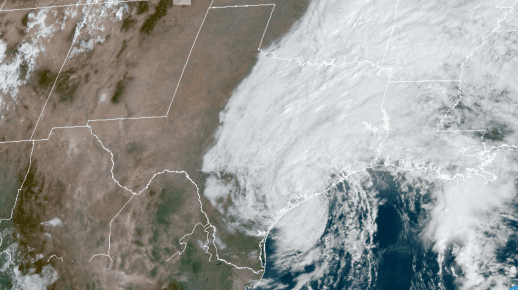
Tropical Storm Beta moved inland near the western end of the Matagorda Peninsula, or about 5 miles south of Port O’Connor, around 10 pm Monday evening. The center of Beta continued moving slowly to the northwest overnight. As of mid-Tuesday morning, Beta was centered about 15 miles northeast of Victoria. Being inland, Beta has weakened to a tropical depression, with maximum sustained winds at 35 mph.
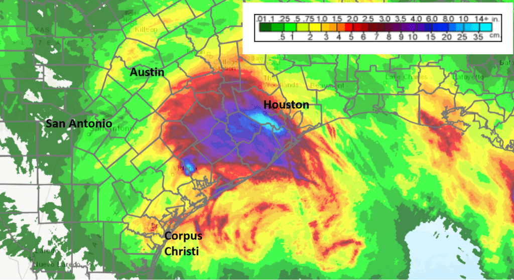
The circulation around Beta produced very heavy rain across parts of the middle and upper Texas coast overnight. Much of eastern Colorado and Wharton Counties saw totals of 4-5 inches, while western Colorado County and much of Fayette County received totals of 2-3 inches. Further inland, the totals were much lighter. The very highest totals overnight occurred further east across southern Harris County, where totals of 10-15 inches were recorded.
NWS Estimate of Rain Falling Between 11 am Sunday and 11 am Tuesday:
The steering currents surrounding Beta remain weak but it appears the storm system has finally made the much anticipated move to the northeast, albeit at only 2 mph. However, water vapor imagery indicates a broad mid-level trough of low pressure pushing east out of western Texas should continue to force Beta east-northeastward at a slightly faster pace this afternoon and tonight, followed by an even faster motion toward the northeast on Wednesday and Thursday. The remnants of Beta are forecast to be over Louisiana and Mississippi on Thursday.
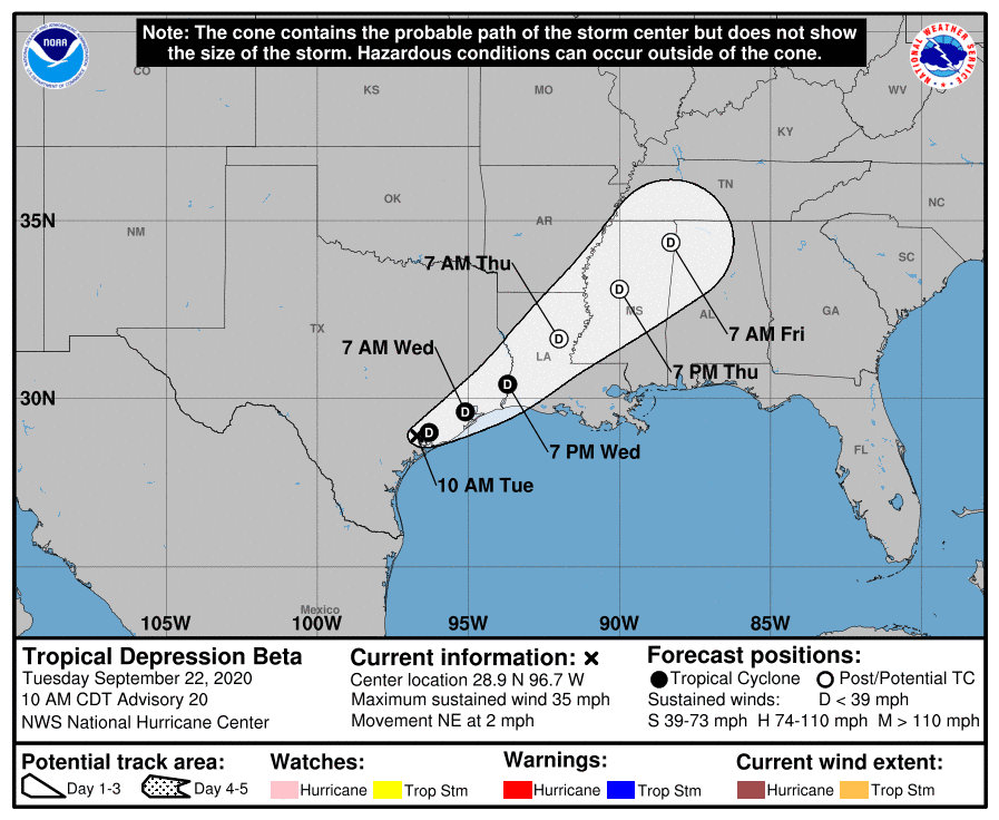
Based on the latest National Hurricane Center forecast track, the center of Beta should move east-northeast, somewhat parallel to U.S. Highway 59, this afternoon and tonight, reaching the Houston area early Wednesday morning. Moisture convergence and lift on the eastern side of the low pressure center is expected to bring waves of moderate to heavy rain showers and scattered thunderstorms to the coastal plains region, extending north into the southern counties of Central Texas this afternoon and tonight. Additional rain totals of 1-3 inches are forecast, with isolated totals to near 5 inches possible.
Further inland, mainly light showers are forecast to wrap around the center of Beta and spread north-northwest to the Austin area and the eastern Hill Country this afternoon and evening. The probability for rain will be near 50 percent, with additional rain totals averaging between 0.25 and 0.5 inches. Little to no rain is forecast Tuesday night into Wednesday morning.
NWS Rain Forecast for the Period 7 am Tuesday through 7 am Friday:
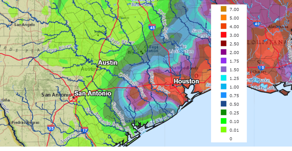
Wednesday’s weather will feature a partly cloudy sky and generally dry conditions across the Hill Country and Central Texas regions. A few scattered rain showers look to continue across the coastal plains region, but rain amounts average less than a quarter inch. Sunny and dry weather is forecast to continue across the region Thursday through Sunday.
Bob
Social Media