The tropical Atlantic continues to be very quiet, with no organized areas of clouds and rain. This has been the story through most of July. One of the main reasons for the lack of activity has been an abundance of Saharan dust across the tropical Atlantic. Strong air currents carrying the dust are generally warm and contain little moisture. This “Saharan Air Layer” containing strong winds, creates an environment that is quite unfavorable for tropical storms and hurricanes to develop.
NOAA’s GOES satellites look at a certain wavelength of light reflected back to the satellite corresponding with the presence of Saharan dust. A satellite image from Tuesday afternoon using this Saharan dust wavelength, showed a large area of dust (the yellow and orange colorings) stretching from the western Caribbean Sea, to the west coast of Africa. The dust was creating an unfavorable environment for storms to develop across a large piece of Atlantic real estate.
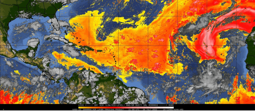
The important question to be answered is how long the dust will persist across the Atlantic? Computer-forecast solutions call for the additional clouds of dust to continue off and on across the tropical Atlantic through at least early August. In most years, wind patterns begin to change across western Africa in early mid-to August, leading to considerably less dust being carried off to the west. So at least from a dust perspective, atmospheric conditions should become a bit more favorable for tropical cyclone development by the middle of the month.
We’ll see if this year’s wind patterns over western Africa will follow the historical trend, and promote a slowdown of Saharan dust in the near future.
Bob
Social Media