The first weekend of autumn featured some outstanding weather. Although afternoon temperatures warmed close to 90 degrees, the nights were cool and humidity levels stayed low. However, low-level Gulf moisture is beginning to make a return and the recent fall-like pattern is quickly fading and will be replaced by one that is warmer and more humid weather for the next couple of days.
Monday’s weather maps showed a trough of low pressure in the upper atmosphere located over southeastern Arizona and a weak ridge of high pressure covering eastern Texas and the Lower Mississippi Valley. The low over Arizona is lifting up to the north-northeast and not expected to have any direct impact on our region’s weather. However, the low will pull scattered clouds inland from the Gulf and Pacific, resulting in a partly cloudy sky and dry weather this afternoon and tonight. Temperatures will be warm, with highs this afternoon near 90-93 degrees. Lows Tuesday morning will range from the upper 60s across the Hill Country to the low 70s near the coast.
Tuesday’s weather will feature a partly cloudy sky and warm temperatures, with highs in the low 90s. There will be a 30-40 percent chance for scattered afternoon rain showers and thunderstorms as moisture levels increase. The chance for rain and storms will increase to near 60 percent Tuesday evening into Tuesday night as a wave of low pressure tracks east out of West Texas. Forecasts call for a large area of rain and storms to develop across the Concho Valley and the western Hill Country Tuesday evening, with the activity spreading east across Central Texas and the middle Texas coast Tuesday night. Rain amounts Tuesday afternoon through early Wednesday morning are forecast to generally average between a half inch and one inch. Isolated higher totals will be possible. Although severe storms are not anticipated, a couple of the storms may be strong—producing small hail and gusty winds.
After a break from the rain Wednesday morning, additional showers and thunderstorms are forecast to develop Wednesday afternoon into Wednesday night as another broad trough of low pressure begins to organize over northern Mexico and southern Arizona. Small waves of low pressure tracking east around the low and spreading into Texas are expected to cause the development of showers and thunderstorms Wednesday afternoon and Wednesday night. Rain amounts Wednesday through early Thursday are forecast to generally average between a half and one inch, with isolated heavier downpours.
High temperatures Wednesday will be near 90 degrees.
There will be an increased chance for rain showers and thunderstorms Thursday through Saturday as the low over northern Mexico slowly lifts to the northeast and small waves of low pressure rotate east across Texas. Periods of moderate to occasionally heavy rain can be expected, with the probability for rain each day being near 80 percent. Forecasts call for daily rain amounts to be between a half and one inch, along with some isolated heavier downpours. High temperatures each day are forecast to be in the low to mid-80s. Low temperatures are predicted to be in the mid-60s.
The wet pattern is forecast to continue next Sunday and Monday as low over Mexico slowly lifts north into the southern Plains states. The probability for rain both days is forecast to be around 40-50 percent. High temperatures both days are expected to be in the low 80s.
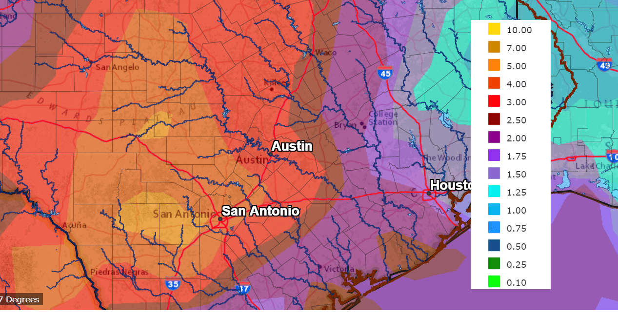
Significant totals of rain are predicted over the next week as the waves of rain and thunderstorms move across Texas. The Weather Prediction Center’s forecast calls of the highest totals to occur across the Hill Country, with slightly lower totals for areas east of Interstate 35. The forecast calls for 7-day totals to range from 4-6 inches across the western Hill Country to around 2-4 inches for the area between Austin and the middle Texas coast.
NWS Rainfall Forecast for the Period 7 pm Monday through 7 pm Next Monday:
The outlook for next week calls for a break in the rain to develop next Tuesday through Friday. High temperatures are predicted to hold in the low to mid-80s, with lows in the 60s.
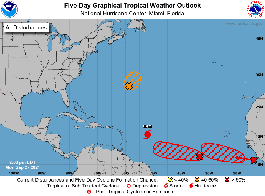
Tropical Weather Update
Weather conditions remain quiet across the Gulf of Mexico and the Caribbean Sea. There are no systems in place which pose a threat for tropical development over the next few days.
Major Hurricane Sam continues to be the focus across the tropical Atlantic at the current time. As of 10 am CDT, Sam was centered over the west central tropical Atlantic, roughly 745 miles east-southeast of the northern Leeward Islands. Sam was moving toward the northwest near 8 mph and this motion is expected to continue for the next few days, with an increase in forward speed beginning on Thursday. A turn to the north is expected on Friday. On the forecast track, Sam is expected to pass well to the northeast of the northern Leeward Islands Wednesday and Thursday. Maximum sustained winds were near 125 mph with higher gusts. Sam is a category 3 hurricane on the Saffir-Simpson Hurricane Wind Scale. Fluctuations in intensity are possible during the next days, although Sam is forecast to remain a major hurricane through at least Thursday night.
National Hurricane Center forecasts call for Sam to track east of Bermuda and remain well east of the U.S. East Coast.
Elsewhere, the National Hurricane Center is keeping a close watch on two systems over the eastern tropical Atlantic.
The first system is a broad area of low pressure located several hundred miles southwest of the Cabo Verde Islands. The low is producing an area of disorganized showers and thunderstorms. Environmental conditions are forecast to be conducive for further development of this disturbance, and a tropical depression is likely to form in a few days while it moves westward to west-northwestward at 5 to 10 mph over the central tropical Atlantic. NHC forecasters are giving this system an 80 percent chance for tropical development over the next 5 days.
The second system is a tropical wave that is currently moving offshore the west coast of Africa and into the far eastern tropical Atlantic. Upper-level winds are forecast to be conducive for gradual development, and a tropical depression is likely to form in a few days while the system moves westward to west-northwestward at 10 to 15 mph over the far eastern tropical Atlantic. NHC forecasters are giving this system an 80 percent chance for tropical development over the next 5 days.
Have a good week.
Bob
Social Media