Breezy and Warm For Easter Sunday. A Chance for Rain Developing Monday Night
March 29, 2024
The month of March will be “going out like a lamb” as weather conditions are expected to remain dry and quiet through Easter weekend. The most noticeable weather changes heading into the weekend will be the warmer temperatures and gusty southerly breezes. Weekend weather conditions are looking great, and it will definitely be feeling a lot like spring.
A strengthening pressure gradient between a developing area of low pressure over the southern Plains states and high pressure over the Gulf of Mexico is expected to cause breezy conditions Friday through Sunday. Forecasts call for sustained southerly winds between 10 and 15 mph, with occasional gusts up to 30/35 mph through the weekend.
The sky looks to be mostly sunny Friday afternoon. Saturday will start off with widespread clouds, but the sky will become mostly sunny by midday. Easter Sunday looks to have a partly to mostly cloudy sky as high-level cirrus clouds spread in the from the west.
Warmer daytime and nighttime temperatures are forecast today through Sunday thanks to the southerly breezes originating off the Gulf of Mexico.
- High temperatures Friday are forecast to be in the upper 70s.
- High temperatures Saturday are predicted to be near 78-80 degrees.
- High temperatures Sunday are forecast to be in the low and mid-80s.
- Low temperatures Saturday and Sunday mornings are predicted to be in the low 60s.
- Low temperatures Monday morning are forecast to be in the upper 60s.
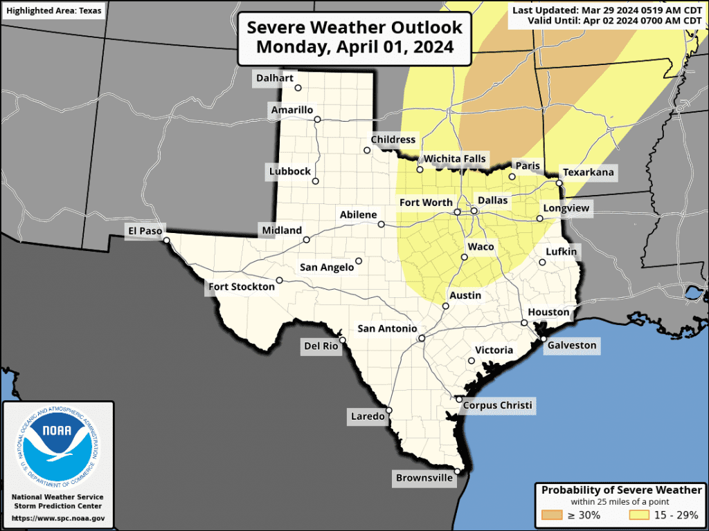
Some changes in our weather are predicted to take place early next week when a large trough of low pressure begins to lift northeast out of the Southwestern U.S. This system is expected to drag a cold front southeast across Texas Monday evening into Monday night. Ahead of the front, mostly cloudy, breezy and warm weather will continue on Monday, with highs in the mid and upper 80s. Monday night, conditions appear favorable for the development of scatted rain showers and thunderstorms ahead of and along the cold front as far south as roughly Intestate 10. The probability for rain will be near 40-50 percent. There are indications some of the storms may become strong to severe across the northern counties of Central Texas. The Storm Prediction Center is highlighting North Texas, extending as far south as about Austin for the potential for severe storms Monday night.
Rain amounts are not forecast to be very high, with most totals averaging less than a quarter inch. Unfortunately, the rain is not expected to make into areas south of Interstate 10.
A dry weather pattern will set up Tuesday and is forecast to continue through late next week. Slightly cooler air will spread into the area behind the cold front Tuesday, and this slightly cooler air should persist through Thursday. Expect daily high temperatures in the mid-70s. Lows will range from the mid and upper 40s across the Hill Country to near 50 degrees across the coastal plains. Forecasts call for dry and slightly warmer weather next Friday, continuing through next weekend.
Early Look at Eclipse Day Sky Forecast
Confidence has increased slightly that an active weather pattern could bring moisture and cloud cover with a chance of rain to our region around the day of the eclipse. The latest forecast model consensus has trended cloudier than what is typical for April 8th, with a roughly 30% chance for favorable viewing conditions across the Hill Country and Central Texas.
But keep in mind, we’re 10 days out from April 8th and there’s still considerable uncertainty in the forecast and with the development of a large trough of low pressure out to our west at that time. Don’t change any plans just yet. The weather forecast for eclipse day will become clearer over the next few days. Stay tuned for additional updates.
Have a Happy Easter and a great weekend!
Bob
Social Media