Some of the hottest temperatures ever recorded in the month of July developed Sunday as an intense heat ridge set up over the region. High temperatures of 105-110 degrees were common across the Hill Country and Central Texas regions. Even the middle Texas coast saw temperatures between 101 and 106 degrees. Sunday’s heat was historic, with readings at several locations approaching not only the hottest July temperatures ever observed, but the hottest temperatures on record.
Monday’s weather maps showed very similar atmospheric conditions to what was observed on Sunday across the state. Although the center of the subtropical ridge, or heat dome, has shifted west to northern Arizona, a bubble of very hot air in lower atmosphere connected with the ridge covers much of the state. This hot sinking air, combined with a strong July sun, very dry soils, and stressed vegetation is once again expected to lead to record heat.
- Monday’s temperature is predicted to warm to a range of 105-110 degrees across the Hill Country and Central Texas regions, and be in a the range of 101 to 106 degrees across the coastal plains.
The National Weather Service has posted an Excessive Heat Warning for the Central Texas region (including the Austin metro area) and the northern Hill Country until 7 pm Tuesday. The warning is for dangerously hot conditions with high temperatures between 105 and 110 degrees and heat index values up to 112 degrees.
The National Weather Service has posted Heat Advisory for the Hill Country and coastal region through 7 pm. The heat advisory is for high temperatures between 103 and 109 degrees, and heat index values up to 110 degrees.
One additional feature to play a role in today’s weather will be a very weak cold front, or wind shift boundary, that has stalled out across Central Texas. Similar to Sunday, the boundary is predicted to be a trigger for the development of isolated to scattered thunderstorms across the region as temperatures warm into the triple digits. The probability for rain at any given location will only be 20 percent. Today’s thunderstorms will be capable of producing strong and gusty winds to around 50 mph. Rain amounts are forecast to generally average around a quarter inch, with isolated totals to near 1 inch possible.
The outlook for Tuesday calls for continued sunny and very hot weather across the region. Temperatures are forecast to decrease roughly 5 degrees as bubble of warm air in the lower atmosphere cools slightly.
- High temperatures Tuesday are forecast to near 103-106 degrees across the Hill Country and Central Texas regions, and be near 99-102 degrees across the coastal plains.
The chance for scattered afternoon thunderstorms looks to decrease Tuesday as the stalled boundary across the region dissipates. A couple of isolated thunderstorms will be possible, but the chance for rain will be well below 20 percent.
Wednesday through the upcoming weekend, expect mostly sunny conditions and slightly lower temperatures as the ridge of high pressure to our west holds in place, but weakens slightly. Generally dry weather is forecast across the Hill Country and Central Texas. However, towards the coast, there will be a slight chance for a few isolated rain showers and thunderstorms each afternoon as the Sea Breeze becomes more active. The rainfall is expected to be quite spotty in nature. Daily high temperatures are predicted to be near 100-102 degrees across the Hill Country and Central Texas regions, and be in the upper 90s across the coastal plains.
The outlook for next week shows few changes. Forecasts call for the broad subtropical ridge to remain over the western and central U.S., while the center of the ridge continues over the Desert Southwest. Mostly sunny, dry and hot weather conditions will continue. However, no extreme temperatures are expected.
- Daily high temperatures are forecast to be around 100-102 degrees across the Hill Country and Central Texas regions, and in the upper 90s across the coastal plains.
Tropical Weather Outlook
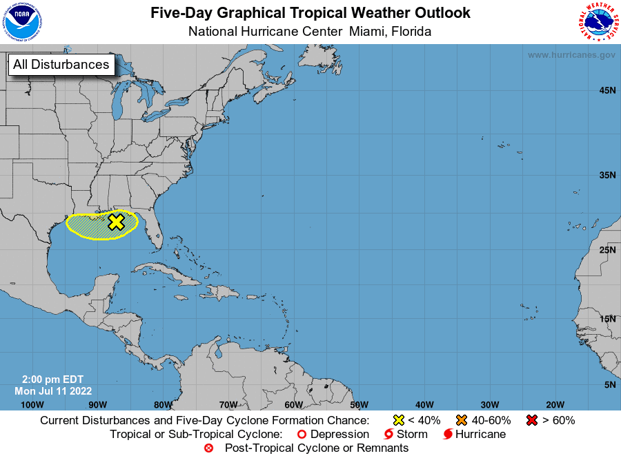
A broad trough of low pressure currently located over the northern Gulf of Mexico is producing a large area of disorganized showers and thunderstorms. Gradual development of this system is possible if it can remain offshore while it meanders near the northern Gulf of Mexico coast through the end of the week.
Tropical cyclone development off the remnants of old fronts are a well-known mechanism for early season development, and though the model guidance has not been terribly consistent, this is definitely a feature that will need to be monitored this week. There is no clear trend yet whether this system will track west towards Texas, or spread toward the southeastern U.S. Stay tuned for additional updates.
NHC forecasters are giving this system a 30 percent chance for tropical development over the next 5 days.
Bob
Social Media