Forecasters are closely monitoring a tropical disturbance located over the western Gulf of Mexico. Afternoon satellite imagery and surface reports suggest a low-level circulation is forming in this region, underneath a mid- to upper-level trough of low pressure. Winds of 30-35 mph were being observed near and east of the center. Shower and thunderstorm activity remains somewhat limited, but any increase in winds or organization could result in the formation of a short-lived tropical depression or tropical storm. The system is forecast to push inland somewhere along the middle Texas coast tonight. NHC forecasters are showing a 60% (medium) chance for tropical development through tonight.
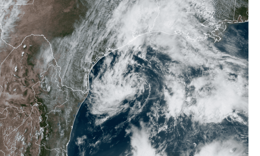
Colorado State University/RAMMB–05/21/2020 3:20 pm CDT
Regardless of development, impacts from this system are predicted to be minimal for the middle Texas coast and across Central Texas. Forecasts call for an increasing chance for rain across the region tonight and through the weekend, but this will primarily be the result of a fetch of deep tropical moisture spreading inland from the central Gulf of Mexico.
Should a low pressure area attempt to organize near the coast later today or tonight, there could be a slight increase in moisture convergence and the potential for cell training on the east side of the feature.
Friday’s weather maps showed a large ridge of high pressure in the upper atmosphere situated over the eastern U.S. while a large trough of low pressure covered the western U.S. Circulation around both features is helping pulling an area of rich, tropical moisture from the Caribbean and Gulf of Mexico into Louisiana and the eastern third of Texas. This feed of moisture, along with the disturbance in the western Gulf, is forecast to cause the development of scattered rain showers and isolated thunderstorms across the middle Texas coast and areas of Central Texas, generally east of Interstate 35 this afternoon. The probability for showers will be near 40-50 percent. The threat for severe storms will be low. For the Hill Country and the Interstate 35 corridor, expect a mostly cloudy sky this afternoon and just a 20 percent chance for scattered rain showers. Today’s temperature is predicted to warm to middle 80s.
Tonight, there will be 30-40 percent chance for scattered rain showers and isolated thunderstorms for most of the region as tropical moisture continues to spread over the area. Lows Saturday morning will be in the upper 60s to low 70s. Rain amounts through early Saturday morning are forecast to average between a quarter and a half inch across the coastal plains, while totaling less than a quarter inch at most other locations.
While not a complete washout, a relatively wet weekend is in store for our region as the deep feed of tropical moisture to our east shifts west into central Texas and the Hill Country. In addition, the disturbance over the western Gulf is forecast to drift inland over South Texas, and will enhance slightly the transport of moisture north from the Gulf. Periodic rounds of showers and embedded thunderstorms are predicted Saturday through Sunday, with the most favorable period for rain occurring in the afternoon and evenings. The probability for rain both days will be near 50-60 percent. Expect a mostly cloudy sky both days, with high temperatures in the low 80s. General totals of 0.25 to 0.50 inches, with isolated totals to 1 inch are forecast both days. Do keep in mind some locally heavy downpours will be possible. The threat for severe storms this weekend appears to be quite low.
The outlook for Monday and Tuesday calls for more periods of showers and isolated thunderstorms across the region, although the rain is predicted to become a bit less widespread. The probability for rain both days is predicted to be near 30-40 percent. Expect high temperatures in the low to mid-80s. Rain amounts are predicted to average around a quarter inch each day.
Wednesday through Friday, expect a partly to mostly cloudy and just a slight chance for mainly afternoon and evening showers and thunderstorms as the flow of tropical moisture decreases. Daily high temperatures are forecast to be in the mid and upper 80s.
An early outlook for Memorial Day weekend calls for a partly sky and a slight chance for scattered afternoon and evening rain showers and thunderstorms as small waves of low pressure track in from the west. Expect high temperatures in the upper 80s.
NEXT WEEK: A LUNAR ECLIPSE! Mark your calendar for early Wednesday morning, May 26th. At that time, the full Moon will pass through the shadow of Earth, producing a total lunar eclipse that will be visible across all of Texas. For 14 and a half minutes, the disk of the Moon will turn orange–the same color as the core of our planet’s shadow. For Texas and the western U.S., this will be a crack-of-dawn viewing event. I’ll pass along more details on the eclipse next week.
Have a good weekend.
Bob
Social Media