There were some hints of fall in the air early Friday morning as temperatures fell into the 50s across the Hill Country and the low to middle 60s across Central Texas. Dry air spreading in behind Wednesday’s cold front allowed temperatures to cool off rather nicely. According to LCRA’s Hydromet, the lowest recorded temperature was 53 degrees, at gauges located near the LBJ Ranch in eastern Gillespie County and also near Pedernales Falls State Park in Blanco County.
Weather conditions remain quiet across our region as we remain under in the influence of a large summertime high pressure ridge which covers most of the western U.S. Interestingly, winds flowing clockwise around the ridge are carrying a moderate amount of smoke from the western wildfires south across the Plains states and into Texas. Although today’s sky will be sunny, the smoke is expected to cause the sky to look somewhat hazy. Afternoon temperatures will be hot, with readings generally climbing to the mid-90s. A few spots along the I-35 corridor could reach the upper 90s. Expect an east wind at 5-10 mph.
A clear sky and pleasant readings are forecast Friday night. Lows Saturday morning will range from the mid and upper 50s across the Hill Country to the low and mid-60s across Central Texas, with mid-60s even across the coastal plains.
Sunny weather will continue Saturday, with afternoon temperatures generally in low to mid-90s. Lows Sunday morning will be a bit warmer, generally in the upper 60s to low 70s.
Some changes in the weather are predicted for Sunday when a large plume of tropical moisture is forecast to begin spreading inland from the western Gulf of Mexico. Expect a mostly to sunny to partly cloudy sky across the Hill Country and Central Texas. Meanwhile towards the coast, the sky is forecast to become mostly cloudy by the afternoon. Here, there will be a 40 percent chance for showers Sunday morning, followed by a 60 percent chance for showers and thunderstorms Sunday afternoon and Sunday night. Some locally heavy downpours will be possible. For locations between Bastrop and La Grange, the chance for rain will be near 40 percent Sunday afternoon and Sunday night. For Austin and the Interstate 35 corridor, the chance for rain Sunday and Sunday night will be 20 percent. High temperatures Sunday will be in the low 90s. Rain amounts between Sunday afternoon and daybreak Monday are forecast to average between 0.5 and 1 inch across the coastal plains. Totals across Central Texas should average around a quarter inch or less.
Closely Watching the Gulf this Weekend and Next Week
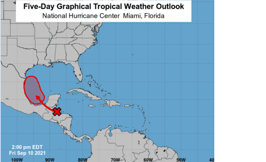
National Hurricane Center forecasters are closely monitoring the western Caribbean Sea, portions of Central America and the Yucatan peninsula where the northern portion of a tropical wave is producing disorganized showers and thunderstorms. This system is forecast to move into the Bay of Campeche and merge with a pre-existing surface trough located over the southwestern Gulf of Mexico by Sunday. Environmental conditions are expected to be conducive to support gradual development, and a tropical depression is likely to form Sunday or Monday before the system moves onshore along the western Gulf of Mexico coast. NHC forecasters are giving this system a medium chance (40 percent chance) for tropical development through Saturday and a high chance (70 percent chance) tropical development over the next 5 days.
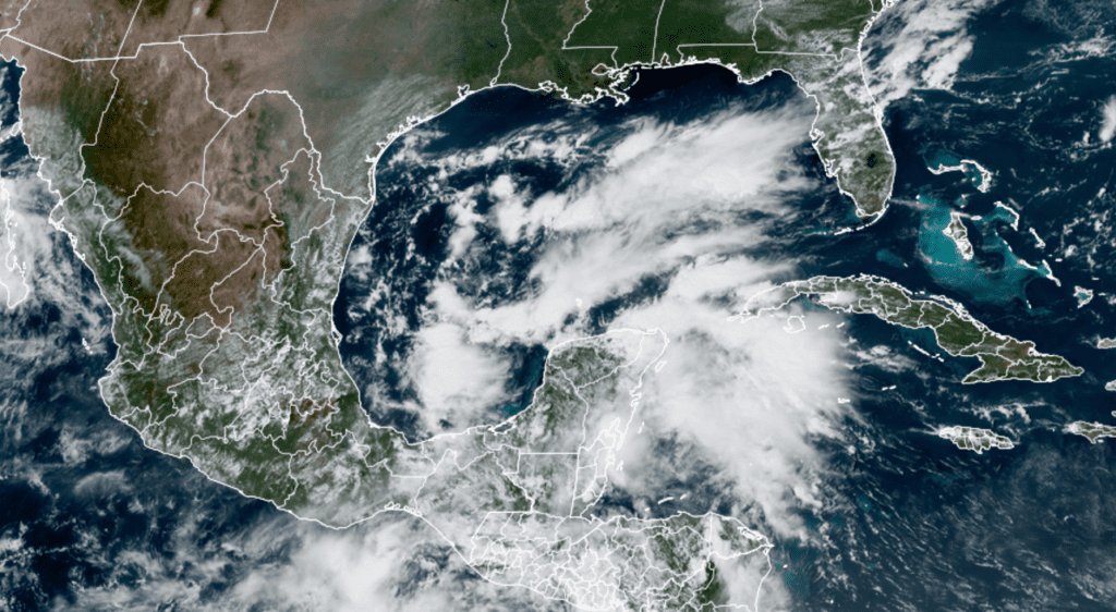
NOAA/Colorado State University/RAMMB 09/10/21 1:40 pm CDT
Most forecast guidance keeps this potential tropical cyclone quite weak. At this point, there is considerable uncertainty as to the eventual track of the system. Some guidance calls for a track north along the Texas coast next week while others advance the system further inland across South Texas. It’s too early to have a good handle on the forecast track just yet.
Forecasts call for considerable tropical moisture to spread inland early next week, unrelated to potential tropical cyclone. Additional waves of rain and thunderstorms are expected to continue mid to late week as the tropical cyclone, or its remnants, come further north. As of now, forecasts call for the heaviest and most widespread rain to be focused across the middle and upper Texas coast plus most of Southeast Texas. Lower rain amounts are forecast across Central Texas, the Interstate 35 corridor and the eastern Hill Country. Should the potential tropical system take a path more into South Texas, rain amounts could increase substantially across Central Texas and parts of the Hill Country.
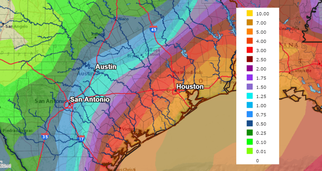
The National Weather Service’s 7-day rainfall forecast, based on the tropical system taking a path up the Texas coast, calls for totals of 5-8 inches across Matagorda and parts of Wharton Counties, 3 to 5 inches across Fayette and Colorado Counties, and 1-3 inches between Bastrop and La Grange. Austin and the I-35 corridor should see totals near 1-1.25 inches. Again, these totals could shift further west or east depending on the eventual path of the tropical system.
NWS Rainfall Forecast for the Period 7pm Friday through 7 pm Next Friday:
The bottom line is next week’s weather is looking wet, and could be quite wet across the coastal plains. High temperatures will generally be in the upper 80s to low 90s.
Forecasts looking out into the week of September 23rd call for high temperatures to hold mostly in the low 90s.
Tropical Weather Outlook
Hurricane Larry was located early Friday afternoon over the northern Atlantic and was quickly approaching southeastern Newfoundland. Highest winds were near 80 mph.
A strong tropical wave is expected to emerge off of the west coast of Africa by Friday night. Environmental conditions are forecast to be conducive for gradual development thereafter, and a tropical depression is likely to form late this weekend or early next week as the system moves west-northwestward over the far eastern Atlantic near the Cabo Verde Islands. NHC forecasters are giving this system a high chance (70 percent chance) for tropical development over the next 5 days.
Have a good weekend.
Bob
Social Media