Here is an update on tropical storms Marco and Laura. Confidence has increased that neither of these two tropical storms will have a direct impact on our region’s weather. Wrap around moisture from both systems may bring scattered rain showers to our region Wednesday and Thursday, but heavy rain and strong wind is not forecast.
Tropical Storm Marco
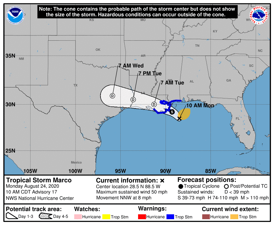
Marco is a very poorly organized tropical storm. Strong southwesterly wind shear is taking its toll, with the edge of the strongest thunderstorms now displaced 50 miles northeast of the exposed circulation center. The shear is not forecast to weaken in the foreseeable future, and Marco could degenerate into a remnant low as early as Tuesday. Based on the latest forecast information, tropical storm conditions are no longer expected over the central Louisiana coast from Marco.
As of 10 am CDT, the center of Tropical Storm Marco was located about 55 miles southeast of the Mouth of the Mississippi River. Marco was moving toward the north-northwest near 8 mph. A turn to the west-northwest is expected to occur by Tuesday, and this motion should continue until the system dissipates in a couple of days. Maximum sustained winds are near 50 mph with higher gusts. Steady weakening is forecast, and Marco is expected to weaken to a tropical depression tonight, and degenerate to a remnant low on Tuesday.
The National Hurricane Center’s forecast track calls for the remnants of Marco to spread into Southeast Texas on Wednesday, then drift southwest towards Laredo and diminish Thursday into Friday. The remnants of Marco may cause some scattered rain showers and thunderstorms across Central Texas and the middle Texas coast Wednesday. However, heavy rain is not forecast, with most totals in the range of 0.25-0.50 inches.
Tropical Storm Laura
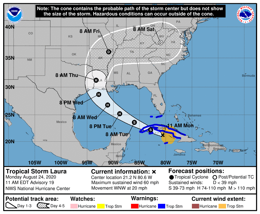
Similar to Marco, Laura is also a fairly disorganized system. Apparently, interaction with the landmass of Cuba, some wind shear and dry air have all altered the structure of the storm. Laura is forecast to pass over the western portion of Cuba this afternoon and emerge over the southeastern Gulf of Mexico late Monday night. Environmental conditions over the Gulf appear to be quite favorable for strengthening and Laura is predicted to reach hurricane intensity by Tuesday evening. Laura is forecast to continue on a west-northwesterly path across the Gulf of Mexico Wednesday, reaching the northwest Gulf Wednesday evening. The tropical storm is forecast to make landfall close to the Texas/Louisiana border late Wednesday night/early Thursday morning then turn to the north and move across western Louisiana on Thursday. There are still a couple of models showing landfall further west towards Galveston, but the National Hurricane Center is leaning toward the model consensus of landfall near Beaumont. Do note the cone of uncertainty at landfall extends as far west as Galveston.
Based on the latest forecast track, Laura is not expected to have a significant impact on Central Texas weather. Some outer rain bands from Laura may spread west to the middle Texas coast and parts of Central Texas on Thursday, but heavy rain is not expected. Most totals should be in the range of 0.25-0.50 inches. Parts of the middle Texas coast could experience gusty winds to near 30-35 mph.
As of 10 am CDT, the center of Tropical Storm Laura was located south of Cuba, about 145 miles east Isle of Youth. Laura was moving toward the west-northwest near 20 mph, and this general motion with some decrease in forward speed is expected over the next day or so. A turn toward the northwest is forecast by Wednesday, and a northwestward to north-northwestward motion should continue through Wednesday night. NOAA and Air Force reconnaissance aircraft indicate that the maximum sustained winds are near 60 mph with higher gusts. Little change in strength is forecast today, but strengthening is expected when the storm moves over the Gulf of Mexico, and Laura is forecast to become a hurricane on Tuesday, with additional strengthening forecast Wednesday. Laura could approach category 2 intensity before landfall.
The outlook for Friday and this weekend calls for the return to typical late summer weather conditions across our region as the ridge of high pressure over the southwestern US spreads across Texas. High temperatures will generally be near 98-100 degrees. There are some indications an area of tropical moisture will spread northwest from the Gulf Sunday into Monday, possibly causing some scattered rain showers and thunderstorms. No significant weather changes are expected next week.
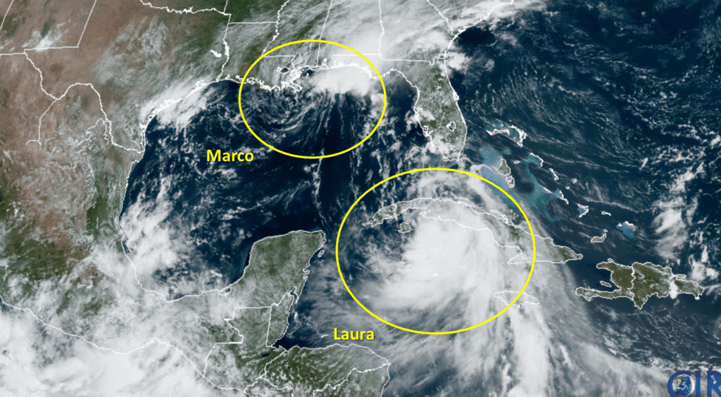
RAMMB-CIRA 08/24/2020 11:40 AM CDT
Bob
Social Media