We’ve been experiencing a generally cloudy and unusually cool stretch of weather since last Friday, with the temperature staying below 60 degrees. The average temperature during this seven-day period has been 9 and 12 degrees below normal! This cold spell is going to be with us for a while yet, with the latest forecasts calling for the cool weather to persist into the middle of next week.
Cloudy and cool weather is in place across the region on this Friday. Widespread low clouds are spreading north from the Gulf in advance of another surge of cold air spreading south out of North Texas. At midday, the leading edge of the cooler air stretched from south of Dallas, to near Brownwood, and west to Fort Stockton. Forecasts call for the colder air to slowly sink south through the Hill Country this evening and overnight, reaching the Austin area before sunrise Saturday, and the coastal plains region by Saturday afternoon. Cloudy and cool weather will continue this afternoon, with high temperatures forecast in the upper 40s across the northern Hill Country, and into the mid and upper 50s at most other locations.
Scattered light rain showers are forecast to develop across the area Friday evening. This will be followed by a more widespread coverage of light rain showers after midnight as an overrunning pattern develops. Lows Saturday morning will include the mid and upper 30s across the Hill Country, the upper 30s to 40 degrees across Central Texas, and the mid-40s across the coastal plains.
Saturday’s weather will be cloudy, damp and chilly as the overrunning pattern continues. Widespread light rain is forecast across the entire region throughout the day, continuing into Saturday evening. Take note that parts of the western and northern Hill Country, between Junction/Rocksprings and Brady/Brownwood, could see a little sleet or freezing rain Saturday morning. No accumulations are forecast. Total rain amounts are not predicted to be very heavy, with most amounts expected to be near or less than a quarter inch. Saturday is going to be a cold day, with little movement in the temperature. Afternoon readings will hold mostly in the low 40s, with mid-40 expected towards the coast.
The chance for rain is predicted to diminish across the region Saturday evening. Under a mostly cloudy sky, lows Sunday morning will include the mid and upper 30s across the Hill Country, be near 38-40 degrees across Central Texas, and in the low to mid-40s across the coastal plains.
Sunday’s weather will feature cloudy and damp conditions as a trough of low pressure begins to push into West Texas out of northern Mexico. Expect a mostly cloudy sky Sunday morning. But by Sunday afternoon, there will be a 30-40 percent chance for rain showers as moisture is drawn north from the Gulf. Sunday’s high temperature are forecast to generally be around 48-50 degrees.
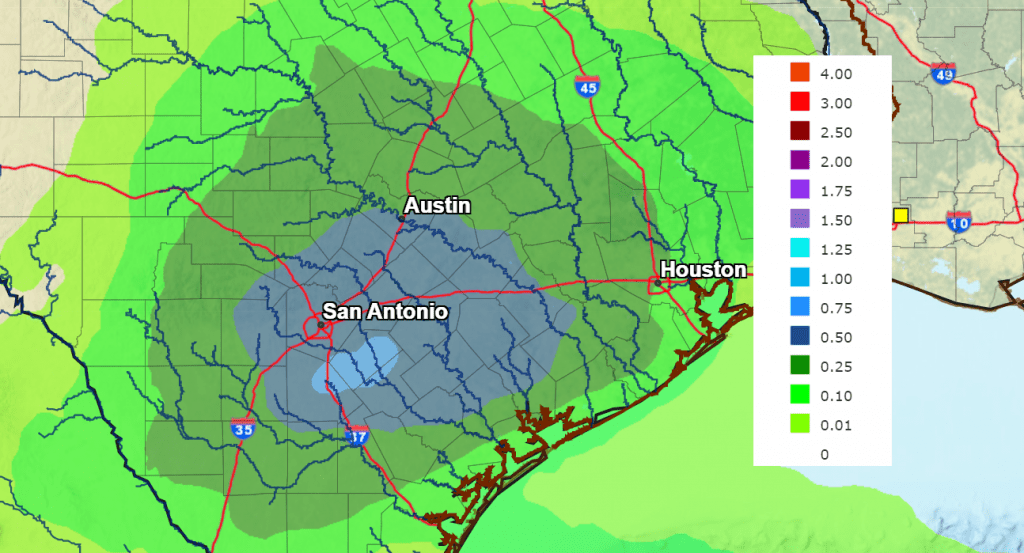
Widespread light rain showers are forecast across the area Sunday night through Monday afternoon as the trough of low pressure slowly moves across Texas. The chance for rain should diminish Monday evening. The rain is predicted to be heavier than what is forecast for Saturday. Totals between Sunday afternoon and Monday evening are forecast to generally average between 0.5 and 1 inch. Lows Monday morning are forecast to be near 38-40 degrees. Highs Monday are predicted to be in the upper 40s.
NWS Rainfall Forecast for the Period 6 pm Monday through 6 pm Tuesday:
A partly to mostly cloudy sky is forecast Tuesday. Lows Tuesday morning will be in the low 40s. Highs on Tuesday are forecast to be in the upper 50s.
The forecast beyond Tuesday, including Thanksgiving Day, is somewhat complicated and a bit uncertain. The various forecast models solutions are struggling with the eventual path and timing of a trough of low pressure that will be tracking east from southern California mid-week. Some solutions take the trough north of our region, resulting in little to no rain across our area Thanksgiving Day. Meanwhile, other solutions call for the trough to take a path more directly across Texas, resulting in more widespread rain. I am leaning on the wetter solution, meaning a chance for rain showers late Wednesday through Thanksgiving Day. Friday and next weekend, the weather is looking generally dry. The National Weather Service is forecasting rain amounts of 0.25 to 0.5 inches across the area for Thanksgiving Day.
There is quite a bit more certainty in the temperature forecast for the second half of next week. Forecast solutions call for the cold pattern to weaken as a ridge of high pressure develops across the Rockies and the western, causing the cold air to moderate. High temperatures Thanksgiving Day, Friday and next weekend are forecast to be in the 60s, with lows in the upper 40s to low 50s.
Tropical Weather Update
Weather conditions are quiet across the tropical Atlantic and there are no systems in place which pose a threat for tropical development for at least the next 5 days.
Have a good weekend.
Bob
Social Media