A brief break in the summer pattern is forecast to take place tonight through Tuesday when an unusual June cold front sinks south out of North Texas. The front is expected to bring scattered rain showers and thunderstorms to much of the region this evening, overnight and Tuesday morning. Drier and slightly cooler air will spread south behind the front and this should keep Tuesday’s temperature in the 80s. This cooldown will be brief as warm and more humid air make a fast return into our area on Wednesday. In fact, mostly sunny, dry and downright hot weather is forecast Thursday and Friday. A chance for rain will return to the weather forecast this weekend when another rare June cold front attempts to push south out the southern Plains.
A moist and slightly unstable air mass is in place across the region ahead of this evening and tonight’s cold front. And with a slightly weaker ridge in place, there will be a slight chance for a few scattered rain showers and thunderstorms across the region this afternoon. The probability for rain will be near 20 percent. Otherwise, expect mostly sunny, hot and very humid weather conditions this afternoon. High temperatures are forecast to generally be in the mid-90s, but factoring into the high humidity levels, peak heat index readings are forecast to reach between 105 and 110 degrees across Central Texas and the middle Texas coast. Because of this, the National Weather Service has posted a heat Advisory for the Austin and Central Texas region until 8 pm.
As of noon, the much anticipated June cold front had moved into Northwest Texas, stretching from just east of Wichita Falls to near Abilene to near Midland. For locations north of the front, temperatures were mostly in the 60s. Forecasts call for the front to make steady progress to the southeast, with the front spreading across the northern Hill Country this afternoon, reaching the Austin area in the early evening. The front is predicted to continue pushing southeast overnight, reaching the I-10 corridor around 3 am and finally pulling up stationary close to I-59/I-69 around daybreak.
Forecasts call for rain showers and scattered thunderstorms to develop along and behind the cold front as it sinks to the south overnight. With a fair amount of atmospheric instability in place, a few of tonight’s storms could be strong to severe, possibly producing damaging winds and large hail. The Storm Prediction Center has placed the entire region under a Marginal Risk (a 1 out of 5 risk) for severe thunderstorms through 7 am Tuesday. Periods of rain showers and thunderstorms are forecast overnight, with the rain ending across the Hill Country and Central Texas shortly after sunrise Tuesday. The chance for rain looks to linger across the coastal plains through about mid-afternoon.
Rain amounts through Tuesday evening are forecast to generally total between a quarter and a half inch across the Hill Country and Central Texas and between 0.5 and 1 inch across the coastal plains. However, isolated totals of 1-2 inches will be possible at a few locations.
High temperatures Tuesday will include the mid-80s across the Hill Country, the upper 80s across Central Texas and be near 90 degrees across the coastal plains. The air will feel noticeably less humid.
Tuesday’s cold front won’t be sticking around for long as it turns around and lifts back north as a warm front Tuesday night. Mostly sunny, dry and hot weather is forecast to resume Wednesday as a ridge of high pressure over northern Mexico strengthens. The center of the ridge is predicted to spread over West Texas Thursday into Saturday. A few isolated showers will be possible across the coastal plains region each afternoon, but other locations should stay dry.
High temperatures are forecast to be in the mid-90s Wednesday and into the upper 90s Thursday through Saturday.
A change in the weather pattern is forecast to take place this weekend when the ridge of high pressure over Texas begins shifting to the west and a large trough of low pressure develops from the Great Lakes region south into northern Texas. Another weak cold front is forecast to sink south and stall across North Texas on Sunday. The combination of the trough, stalled cold front and abundant moisture is expected to cause a slight chance for rain on Saturday, followed a 40-50 percent chance for showers and thunderstorms across the region on Sunday.
The outlook or next week calls for the weather pattern to remain somewhat unsettled as the trough of low pressure remains over Texas and ridges of high pressure set up across the western and southeastern U.S. This ridge/trough/ridge setup is expected to cause a daily chance for rain and thunderstorms across the region throughout the week. High temperatures next week are predicted to generally be in the low to mid-90s.
Tropical Weather Outlook
Tropical Storm Claudette made landfall early Saturday morning southwest of New Orleans. The system pushed inland and moved across the southeastern U.S. Saturday and Sunday. This morning, the center of the system reached the waters of the mid-Atlantic and regained tropical storm strength. As of 10 am CDT, the center of Claudette was located about 90 miles south of Ocean City, Maryland. Claudette was moving toward the east-northeast near 28 mph. An east-northeastward to northeastward motion with some increase in forward speed is expected over the next day or so. On the forecast track, the system will cross into the western Atlantic Ocean later this morning, and pass just south of Nova Scotia on Tuesday.
Maximum sustained winds are near 40 mph with higher gusts. These winds are occurring mostly over water, southeast of Claudette’s center. Some additional slight strengthening is possible over the western Atlantic Ocean today. But Claudette is forecast to become a post-tropical cyclone Tuesday afternoon and dissipate late Tuesday night.
In addition to Claudette, National Hurricane Center forecasters are keeping a close watch on a tropical wave located about 750 miles east-southeast of the Windward Islands. This system is producing disorganized showers and a few thunderstorms. Although shower activity diminished some this
afternoon, recent satellite-derived surface wind data indicate that the wave has become better defined since yesterday. Some additional development of this disturbance will be possible during the next couple of days before upper-level winds become less conducive for further organization by Thursday. The system is expected to move westward to west-northwestward at 15 to 20 mph.
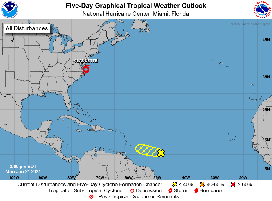
NHC forecasters are giving this system a low chance, a 30 percent chance, for tropical development over the next 5 days.
Elsewhere across the tropical Atlantic, conditions are quiet and tropical cyclone development is not expected for the next 5 days.
Have good week.
Bob
Social Media