A wave of low pressure tracking southwest into Central Texas Thursday afternoon brought widespread rain and thunderstorms to a large part of the Hill Country, with the highest totals occurring from just south of San Saba, to just east of Fredericksburg. According to LCRA’s Hydromet, the highest gauged total was 2.55 inches at a location about 10 miles southeast of Fredericksburg, in Gillespie County. Unfortunately, the rain missed the majority of Central Texas. In Austin, Camp Mabry reported a trace of rain, while Austin-Bergstrom International Airport reported just 0.01 inch.
NWS Estimate of Rain Falling between 7 am Thursday and 7 am Friday:
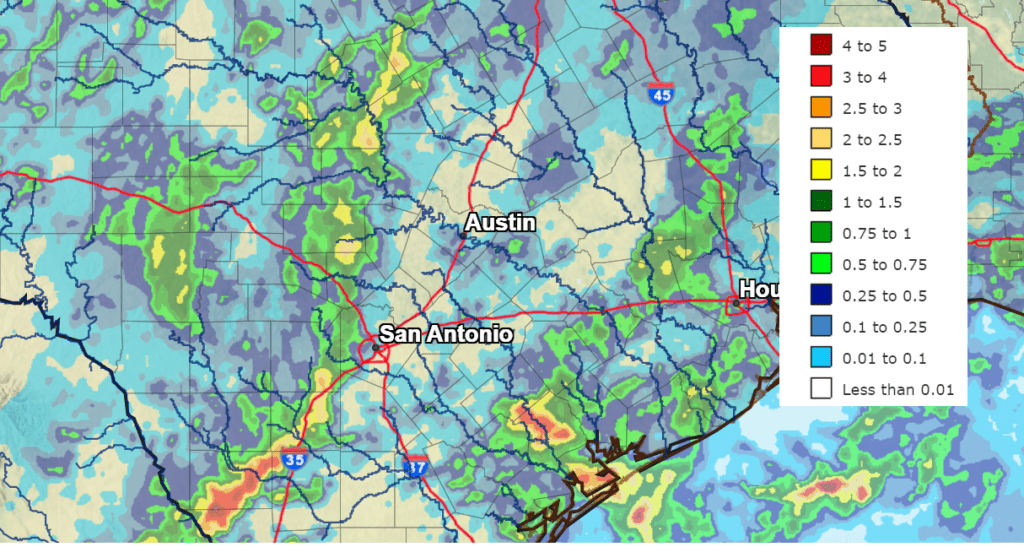
NWS West Gulf River Forecast Center
Some additional scattered showers and thunderstorms are forecast across the region this afternoon, with the highest probability for rain being across the coastal plains. Friday’s weather maps showed a large ridge of high pressure in the upper atmosphere covering the western, central, and southeastern U.S. The ridge is currently centered over southern Colorado and northern New Mexico, meaning the ridge’s dry and hot influence on Central Texas weather is not quite as strong as it was earlier in the week.
One interesting weather feature showing up today is a small, non-tropical area of low pressure located over the Coastal Bend region, between Corpus Christi and Victoria. This low is producing a large area of rain and thunderstorms along and just offshore of the middle Texas coast. The rain is forecast to spread inland Friday afternoon. Some of the rain may be slow-moving and capable of producing large amounts in a short period of time over parts of Matagorda, Wharton, and Colorado counties. Totals through late Friday afternoon are forecast to average between 0.5 and 1 inch, with isolated totals of 2-3 inches possible.
Further inland across Central Texas and the Hill Country, some of this tropical moisture along with leftover moisture from Thursday’s storms will lead to a slight chance for scattered afternoon showers and thunderstorms. The probability for rain will be 20 percent and most totals should stay under a quarter inch.
Friday’s sky will be mostly sunny to partly cloudy and afternoon temperatures are predicted to be less hot. High temperatures are forecast to generally be in the upper 90s across the Hill Country and Central Texas regions, with upper 80s to low 90s expected across the coastal plains.
Sunny, dry and hot weather is forecast over the weekend as moisture levels decrease and the atmosphere becomes more stable. A couple of isolated thunderstorms will still be possible towards the coast, but most other locations look to stay dry.
- High temperatures Saturday are forecast to be near 98-100 degrees across the Hill Country and Central Texas regions, and in the mid-90s across the coastal plains.
- High temperatures Sunday are forecast to be near 100-102 degrees across the Hill Country and Central Texas regions, and in the upper 90s across the coastal plains.
Sunny, dry and very hot weather is forecast next week into next weekend as our region remains under the grips of the large heat dome. Forecasts call for the center of the heat dome to shift from the southern Rockies to the southern Plains states late week into next weekend. This should cause temperatures to trend even hotter the second half of the week.
High temperatures Monday and Tuesday are forecast to be near 101-103 degrees across the Hill Country and Central Texas regions, with upper 90s expected towards the coast.
High temperatures Wednesday through Friday are forecast to be near 102-106 degrees across the Hill Country and Central Texas regions, and near 98-100 degrees across the coastal plains.
Looking out into the week of July 25th, no significant changes in the hot and dry pattern are expected. However, forecasts do call for the center of the heat dome to shift further west to Utah and Nevada, meaning the heat dome should have less influence on our weather at that time. Temperatures should trend down a few degrees and the Sea Breeze might become a bit more active. Stay tuned…
Tropical Weather Outlook
Weather conditions remain quiet across the tropical Atlantic, the Caribbean Sea and the Gulf of Mexico. There are no systems in place which pose a threat for tropical development over the next 5 days.
Have a good weekend and try to stay cool.
Bob
Social Media