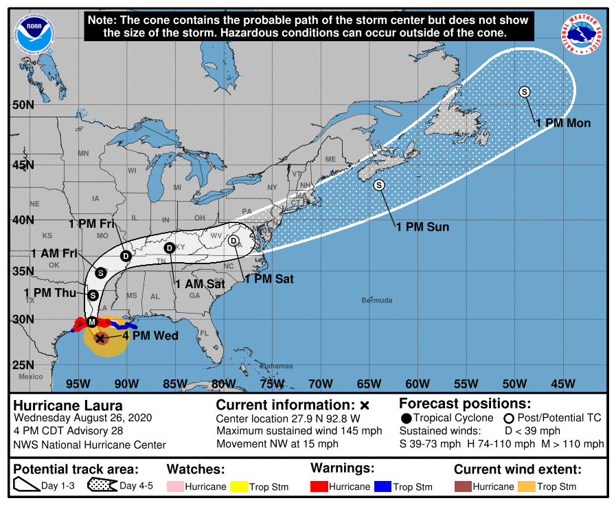
The following is an update on Major Hurricane Laura based on the 4 pm National Hurricane Center Advisory.
…A Hurricane Warning has been posted from San Luis Pass Texas to Intracoastal City Louisiana…
…A Tropical Storm Warning has been posted from Sargent Texas to San Luis Pass…
…A Catastrophic Storm Surge, Extreme Winds and Flash Flooding Expected Along the Northwest Gulf Coast Tonight…
Hurricane Laura rapidly strengthened over the course of the day, with maximum sustained winds as of 4 pm at 145 mph. Laura is an extremely dangerous category 4 hurricane on the Saffir-Simpson Hurricane Wind Scale. Some additional strengthening is still possible this evening and top winds could reach 150 mph before Laura reaches the northwest Gulf coast overnight. Laura’s intensity has increased a phenomenal 55 mph over the past 24 hours!
No significant changes were made to the forecast track in the National Hurricane Center’s 4 pm update. The cone of uncertainty at landfall has narrowed to the area between Port Arthur, Texas and Lake Charles, Louisiana. Laura is currently moving toward the northwest near 15 mph. A turn toward the north-northwest and north is expected tonight, and a northward motion should continue on Thursday. A northeastward to east-northeastward motion is expected Thursday night and Friday. On the forecast track, Laura will approach the extreme Upper Texas and southwest Louisiana coasts this evening and move inland within that area near or just after midnight. The center of Laura is forecast to move over northwestern Louisiana tomorrow afternoon, reaching Arkansas Thursday night, and the mid-Mississippi Valley on Friday.
Laura is a large hurricane, with hurricane-force winds extending outward up to 60 miles from the center and tropical-storm-force winds extending outward up to 205 miles from the center. Afternoon visible satellite imagery reveals a very distinct 25 nautical-mile-wide eye embedded in a symmetric central dense overcast. The upper-level outflow has also become well established in all quadrants.
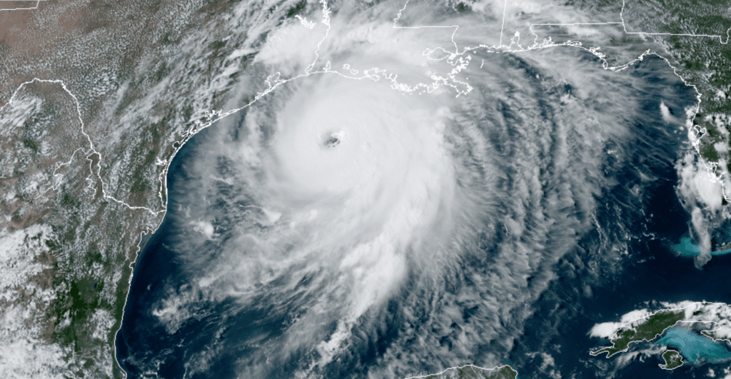
NOAA-RAMMB 08/26/2020 3:20 pm CDT
Updated forecasts continue to call for no direct impacts from Laura on Hill Country, Central Texas or coastal weather tonight into Thursday. Occasional rain bands with light to moderate rain may spread west across the coastal plains to near Interstate 35 tonight into Thursday afternoon. Most rain amounts should average around a quarter inch, with isolated totals to near 1 inch will be possible. Little to no rain is expected across the Hill Country. Some wind gusts to near 30-35 mph will be possible across Wharton and Matagorda counties tonight into Thursday morning.
The chance for rain should decrease Thursday evening as Laura pulls away from Texas.
By the way, NHC forecasters are monitoring a strong tropical wave that is expected to move off of the west coast of Africa tonight and move to the west. Although environmental conditions do not appear to be conducive for development as the wave crosses the eastern Atlantic over the next few days, conditions could become more favorable for slow development of the system as it reaches the central and western tropical Atlantic early next week. Stay tuned for additional updates.
Bob
Social Media