… A long-lived, slow moving system tropical storm or hurricane in the western Gulf of Mexico will impact our region’s weather through at least next Thursday…
…Very heavy rain and coastal flooding will be big concerns for the Texas coast beginning Sunday…
Afternoon satellite imagery indicated the circulation of Tropical Depression 22 became better defined. Satellite wind estimates increased to 35 knots. Based on this and data from a Gulf buoy, the depression was upgraded to a tropical storm and given the name “Beta”, using the second letter from the Greek alphabet.
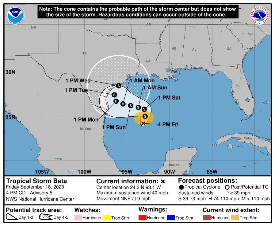
As of 4 pm CDT, the center of Tropical Storm Beta was located in the western Gulf of Mexico, roughly 280 miles east-southeast of the mouth of the Rio Grande River. Beta was moving toward the north-northeast near 9 mph and this general motion is expected through Saturday. Maximum sustained winds have increased to near 40 mph with higher gusts. Additional slow strengthening is expected through the weekend, and Beta could be near hurricane strength by Sunday or Sunday night.
Only minor changes to the forecast track were made on the afternoon update from the National Hurricane Center. Beta is forecast to move slowly to the northeast tonight and Saturday followed by a slow westward motion beginning late Saturday. The storm is forecast to continue moving to the west Sunday through Monday morning. Beta is forecast to reach a position just off the coast of Corpus Christi Tuesday, then begin to recurve to the northeast. Forecasts call for the center of Beta to track northeast near or just off the middle Texas coast Tuesday through Wednesday, before pulling away to the northeast on Thursday.
As mentioned earlier, Beta is forecast to strengthen into a category 1 hurricane by late Sunday night or early Monday morning, but weaken back to being a strong tropical storm Tuesday afternoon into Wednesday when it brushes by the middle Texas coast.
There are still a lot of moving parts to this track forecast—especially for next Tuesday and Wednesday, so don’t get fixated on the center line of the forecast cone of uncertainty.
Rain squalls are predicted to approach the middle Texas coast Sunday as deep tropical moisture begins spreading inland. These rain squalls are expected to increase in frequency and intensity across the coastal plains region Sunday night into Monday while they push further inland. Heavy rain will continue across the coastal region Tuesday through Wednesday, with the rain expected to trend lighter on Thursday. Very windy conditions (tropical storm force winds) will develop Monday night and are predicted to continue through late Wednesday. It is possible some locations could see 24-48 hours of sustained tropical storm force winds due to the slow movement of the system.
Based on the latest forecast track, rain showers and isolated thunderstorms are forecast to spread northwest to the Austin/Interstate 35 corridor Sunday night, with periods of light to moderate rain continuing across the area Monday through Wednesday.
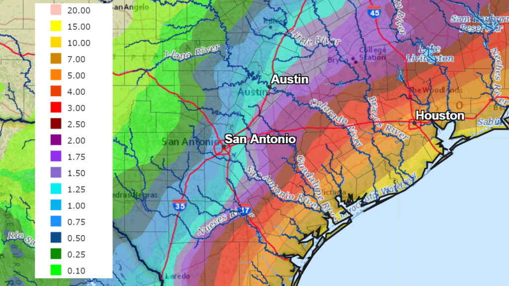
Rainfall forecasts have not changed very much. Very high totals of rain are predicted for the coastal plains regions! Rainfall totals over the next 7 days are forecast to range from around a half inch across the Hill Country, to near 1-2 inches in the Austin area, to around 3-4 inches in the La Grange/Columbus area. Closer to the coast, totals of 5-7 inches are forecast between Columbus and Wharton. South of Wharton, totals of 7 to 15 inches are forecast.
NWS Rainfall Forecast for the Period 7 pm Friday evening through 7 pm next Friday:
Minor to moderate coastal flooding is expected. Minor starting Saturday night. Moderate flooding Sunday night and Monday, with max tides 6 feet or higher possible relative to MLLW, 3 to 4 feet relative to MHHW.
Interests along the western Gulf of Mexico coast should monitor the progress of Beta. Storm Surge and Tropical Storm or Hurricane Watches will likely be required for portions of the western Gulf coast tonight or on Saturday.
Bob
Social Media