Light rain showers developed across the region Thursday afternoon into early Friday morning as a weak trough of low pressure tracked east across northern Texas. According to LCRA’s Hydromet, most rain totals were less than a tenth of an inch. The rain came to an end early Friday morning as the low pressure trough exited to the northeast.
Cool temperatures are in place on this Friday following the passage of a cold front late Wednesday into early Thursday. As of midday Friday, the front was stationary over the coastal plains region — stretching from Houston, to Victoria, to near Cotulla. The front is predicted to remain stalled near the coast this afternoon, then begin retreating back to the north Friday night into Saturday morning. This afternoon’s sky is forecast to remain cloudy to mostly cloudy as considerable moisture spreads northeast into Texas out of the Pacific. High temperatures are forecast to generally be near 60-65 degrees, with lower 70s expected towards the coast.
The sky looks to remain cloudy Friday night. Areas of fog and patchy drizzle are forecast to develop over the area between the Interstate 35 corridor and the coast. Lows Saturday morning will range from the low 50s across the Hill Country to the mid-50s across Central Texas to the mid-60s near the coast.
Saturday’s weather feature will widespread clouds and occasional drizzle through the morning hours, followed by a mostly cloudy sky in the afternoon. There will be a slight chance for a few scattered rain showers along the warm front as it lifts back to the north. Breezy and milder conditions will develop in the afternoon following the passage of the warm front. Expect high temperatures in the mid and upper 70s along with southerly winds at 10-20 mph and occasional gusts to 30 mph. Cloudy, breezy and mild conditions are forecast Saturday night. Lows Sunday morning will generally be in the low 60s, with upper 60s expected towards the coast.
Forecasts call for an increasing chance for rain showers and thunderstorms across the region beginning midday Sunday, continuing through Sunday evening when a Canadian cold front pushes south through the area. The probability for rain will be near 60-70 percent. There are some indications a few of the thunderstorms may be strong—producing strong winds and small hail. Sunday’s temperatures will be mild, ranging from the upper 60s west to the upper 70s near the coast. The cold front is predicted to move off the coast Sunday evening, allowing noticeably cooler air to spread into the area.
Widespread light to occasionally moderate rain showers are forecast across the region Sunday night through Monday night as an area of low pressure over the Desert Southwest slowly lifts northeast across the Texas Panhandle. This low is expected to cause a pattern of overrunning clouds and widespread rain. Forecasts call for occasional light rain continuing Tuesday as one last wave of low pressure moves in from the west. The chance for rain is forecast to end late Tuesday as this last wave exits to the east.
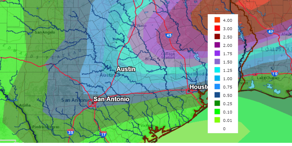
Rainfall between Sunday and late Tuesday is forecast to be significant. Totals through the period are predicted to average between a quarter and a half inch across the western and central Hill Country. Across the eastern Hill Country and most of Central Texas, totals are forecast to average around 1-1.25 inches. Meanwhile towards the coast, totals are forecast to average around a half inch.
NWS Rainfall Forecast for the Period 6 pm Friday through 6 pm Wednesday:
Temperatures will be cooler across the region Monday and Tuesday. High temperatures are forecast to be in the mid-50s Monday, warming to the low 60s Tuesday. Lows Tuesday morning will be in the low and mid-40s.
Forecasts call for sunny, dry and mild weather beginning next Wednesday when a stable ridge of high pressure begins to take shape across the southern Plains and the southern Rockies. The sunny and mild pattern is forecast to continue late next week into next weekend as well. Daily high temperatures are forecast to be in the low 70s, with low temperatures mostly in the upper 40s.
Looking out into the middle of March, there are no signs of freezing temperatures or arctic air.
Have a good weekend.
Bob
Social Media