Thursday’s gusty winds finally diminished by sunset allowing the temperature to fall overnight. According to LCRA’s Hydromet, the temperature fell below freezing early Friday morning across the northern and western Hill Country, with numerous readings dipping into the upper 20s to low 30s. Elsewhere, lows were in the mid to upper 30s across the Hill Country, in the upper 30s to low 40s across Central Texas and in the mid to upper 40s across the coastal plains. It took a while, but I think we can now confidently say fall is finally here.
Pleasant, fall-like weather conditions are in place in the wake of Tuesday’s strong cold front. Friday’s weather maps showed a very stable atmosphere in place across Texas thanks, to a broad ridge of high pressure situated over the south central U.S. This ridge is forecast to remain over our area through the weekend and all of next week, causing more sunny, dry and pleasant weather. Today’s temperature is forecast to warm to 68-70 degrees. Lows Saturday morning will range from the mid and upper 30s across the Hill Country to the mid-40s across the coastal plains. Highs Saturday will be in the low 70s.
There won’t be anything spooky about Halloween night’s weather. The sky will be clear and temperatures will be cool. Readings at 6 pm should be in the low 60s, falling to the mid and low 50s at 9 pm. Expect a light south wind at 5-10 mph. Low Sunday morning will range from the mid-40s across the Hill Country to the low 50s near the coast.
A cold front is forecast to sweep south across the region Sunday morning into Sunday afternoon. This front will mainly reinforce the dry and cool weather already in place. Due to the very dry and stable atmosphere in place, no clouds or rain are expected. Winds will shift out of the north and increase to 10-15 mph behind the cold front Sunday afternoon. High temperatures will be in the upper 60s to low 70s. It will turn quite chilly Sunday night as wind speeds drop off. Lows Monday morning will include the mid and upper 30s across the Hill Country, the low 40s across Central Texas and the mid to upper 40s towards the coast.
- High temperatures next Monday through Wednesday will generally be in the low and mid-70s, rising to near 78-80 degrees Thursday and continuing through next weekend.
- Lows Tuesday morning will range from the upper 30s across the Hill Country to the mid-40s across the coastal plains.
- Lows Wednesday through Saturday morning will be mostly in the 50s.
Long-range forecast solutions call for the current dry and quiet weather pattern to change beginning early the week of November 9th when the ridge of high pressure over Texas weakens and shifts to the east. Forecasts call for a large trough of low pressure to push inland along the West Coast early in the week, with the trough tracking east to the middle of the country by mid-week. As of now, I am expecting there to be an increasing chance for rain across our region through the first half of the week. Temperatures are forecast to remain mild, with highs in the upper 60s to low 70s. Stay tuned for more details on this upcoming pattern change.
Tropical Weather Outlook
This year’s hurricane season is far from over and we may see yet another named storm over the weekend or early next week.
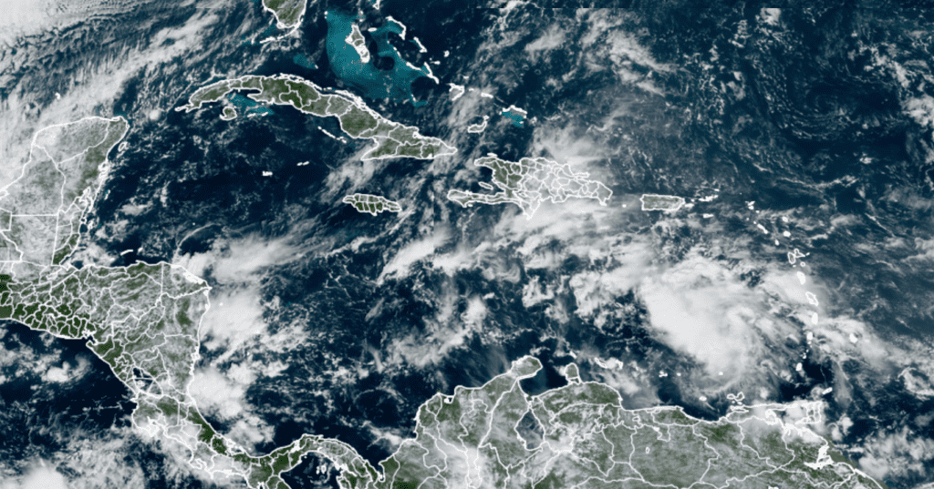
National Hurricane Center forecasters are monitoring an area of clouds and shower activity associated with a tropical wave located over the eastern Caribbean Sea, just to the west of the Windward Islands. Satellite data indicates this this area of disturbed weather continues to getting better organized and conditions are conducive for further development of this system. According to NHC, a tropical depression is likely to form this weekend or early next week as the system moves into the central and western Caribbean Sea. NHC forecasters are giving this system an 80 percent chance for development over the next 5 days.
Forecasts call for this system to track west towards Central America. It poses no threat to Texas.
RAMMB/CIRA/Colorado State University 10/30/2020 11:20 am CDT
The next name on the Atlantic list of storms is the seventh letter in the Greek alphabet, Eta. If Eta does develop, it will tie 2020 with 2005 for the most named storms in an Atlantic hurricane season, with 28. FYI, one of the storms in 2005 was not named because it was discovered in post-season analysis, so this will be the first use of the name “Eta” in any Atlantic season.
Time Change Weekend
A reminder this weekend will be time change weekend as we move back to Central Standard Time. The time change will occur Sunday morning, November 1st, at 2:00 am. At that time we “fall back”, or turn our clocks back one hour. For many of us, it will mean an extra hour of sleep. Don’t forget to check your smoke alarms at the same time.
A Full Moon, A Blue Moon and Mars for Halloween
Don’t miss the rare appearance of a full moon on Halloween, something that hasn’t been seen across the US since 1944. However, as the full moon comes at a time when the moon is at its farthest from Earth, it will also be a “Micro Moon,” the opposite of a “Super Moon,” meaning it looks a little smaller than the usual full moon. And if that still isn’t enough names for you, its status as the second full moon of autumn makes it a “Beaver Moon,” according to NASA.
This is will be the second full Moon in the calendar month of October, thus making it what some call a “blue moon”. (No, the moon will not appear blue)
While checking out the full moon, take note of the bright orange dot shining to the upper right of the moon; this will be the planet Mars. The two bodies will be about three fists at arm’s length apart.
Have a good weekend,
Bob
Social Media