A quiet, early-fall weather pattern continues across Texas. Canadian high pressure ridging south into the state is causing warm days and pleasantly cool nights. Over the weekend, temperatures dipped into the 40s and 50s across the Hill Country and Central Texas regions. These are the coolest readings observed across the area since last April. According to LCRA’s Hydromet, the lowest observed temperature over the past couple of days has been 43 degrees, at a gauge located in southern Llano County, about 10 miles north-northeast of Willow City. In Austin, Camp Mabry’s lowest temperature so far has been 55 degrees. Austin-Bergstrom’s lowest temperature so far has been 48 degrees.
Monday’s analysis showed a very stable weather pattern across Texas, thanks to a broad ridge of high pressure in the middle and upper atmosphere. At the surface, Canadian high pressure is ridging into Texas from the Great Lakes region, bringing in dry and slightly cooler air. The dry air has been responsible for the recent stretch of warm days and cool nights. Forecasts call for few changes in the weather this week as the ridge of high pressure remains over our area. Expect a mostly sunny sky through Friday. Slightly milder overnight low temperatures are forecast Thursday and Friday mornings due to a bit higher relative humidity levels.
- High temperatures this afternoon through Friday are forecast to be in the upper 80s across the Hill Country and coastal regions. Across Central Texas, readings look to climb up to 90 degrees beginning Tuesday.
- Low temperatures Tuesday and Wednesday mornings are predicted to be in mostly in the mid and upper 50s.
- Lows Thursday and Friday mornings will range from the upper 50s west, to the mid-60s near the coast.
A Canadian cold front is forecast to push south across our area Friday night, bringing with it a reinforcing shot of cool, dry air. With limited moisture in place, no rain is expected with the front. Expect a mostly sunny sky and somewhat breezy conditions over the weekend. High temperatures are predicted to be in the mid and upper 80s, while low temperatures will be in the 50s.
Few changes are predicted through the first half of next week. Expect continued sunny weather, with high temperatures around 88-90 degrees.
There are indications a slight chance to a chance for rain will develop across the area late next week when a rough of low pressure moves east out of the Desert Southwest. Increasing moisture off the Gulf may lead to the development of some scattered rain showers across the area. However, significant totals of rain are not expected.
Dry weather and slightly cooler air will follow in the wake of the trough next weekend, with high temperatures falling to the low 80s. Low temperatures will continue in the 50s.
Tropical Weather Update
National Hurricane Center forecasters are monitoring a tropical wave located in the central tropical Atlantic, several hundred miles east of the southern Windward Islands. This system is producing numerous disorganized showers and thunderstorms. However, NHC forecasters do indicate slow tropical development will be possible during the next several days while the wave moves generally westward at 15 to 20 mph. The system is forecast to reach the Windward Islands and the eastern Caribbean Sea by midweek. NHC forecasters are giving this system just a 20 percent chance for development over the next 2 days, and a 30 percent chance for development over the next 5 days.
Over in the far eastern tropical Atlantic, showers and thunderstorms have increased today in association with an area of low pressure located a few hundred miles south-southwest of the Cabo Verde Islands. Environmental conditions appear to be conducive for gradual development, and a tropical depression is likely to form in a day or two. Further development will become less likely late this week due to increasing upper-level winds. The system is forecast to move west-northwestward and then turn northwestward into the eastern tropical Atlantic by midweek. NHC forecasters are giving this system a 70 percent chance for development over the next 5 days.
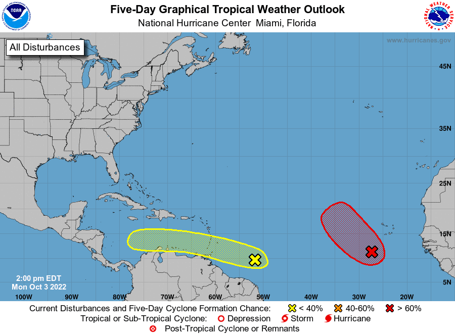
Elsewhere, conditions are quiet and tropical cyclone development is not expected over the next 5 days.
Bob
Social Media