The National Hurricane Center (NHC) continues to closely monitor the strong tropical wave located in the in the southern Caribbean Sea. This system has now been given the official designation of “Invest 99”. There unfortunately isn’t a large amount of new information to report this afternoon as the system has yet to develop any sort of low pressure area. We should begin to get a better handle on the forecast track and intensity of the system over the next couple of days.
In the NHC 1 pm update, forecasters noted a broad area of low pressure is expected to form over the southwestern Caribbean Sea during the next day or so from the tropical wave located north of Colombia. Environmental conditions still look quite favorable for development over the next few days, and a tropical depression or tropical storm is likely to form late this week or over the weekend. The system is expected to move northwestward over the northwestern Caribbean Sea and near or across the Yucatan Peninsula of Mexico on Friday and into the Gulf of Mexico this weekend, where conditions are expected to be favorable for additional development. NHC forecasters have raised their probability for development up to 50 percent over the next two days, and up to 80 percent over the next 5 days. An Air Force Reserve reconnaissance aircraft is scheduled to investigate the system Thursday afternoon, if necessary.
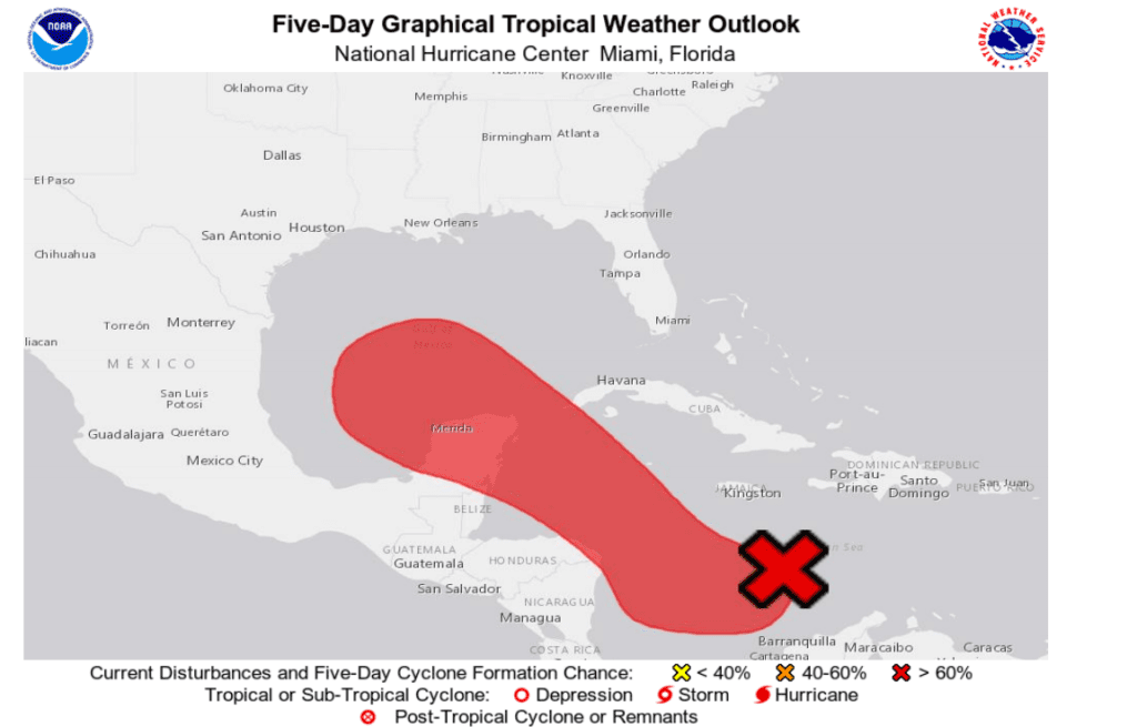
Today’s computer-forecast model solutions continue offer a wide spread of possible tracks inland, ranging from the southern Texas coast, to the central coast of Louisiana. Many of the ensemble solution tracks are pointing toward the upper Texas and southwestern Louisiana coasts, but it’s way too early to put much confidence even in these solutions. Once the system finally gets organized, the modeling should begin to get a much better feel as to where this system will go and how intense it could become. Landfall is expected to occur sometime next Monday or Tuesday. This system will have the potential to strengthen into a strong tropical storm or minimal hurricane.
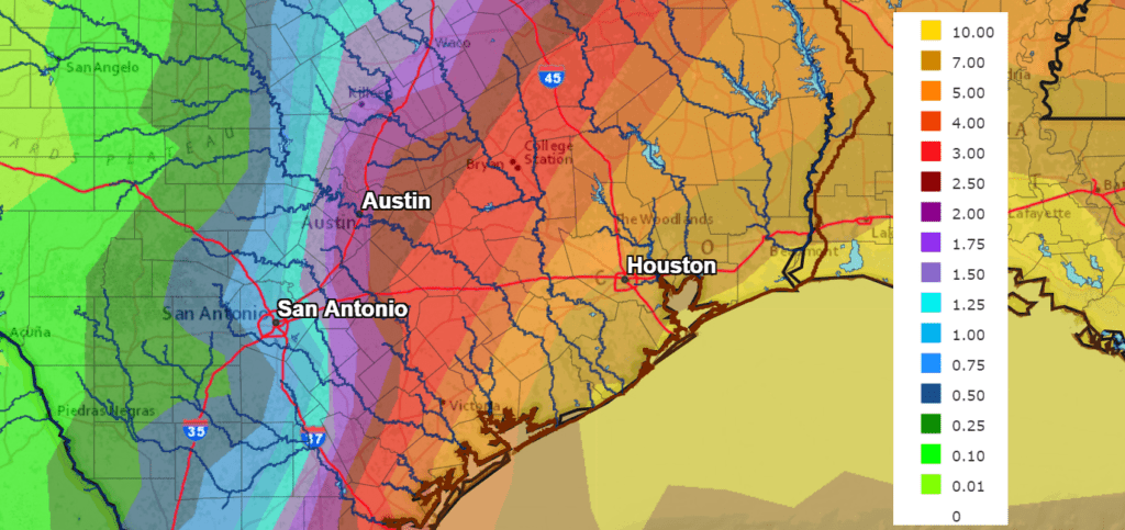
The National Weather Service’s rainfall forecast for the next seven days calls for significant totals of rain to fall over most of Louisiana and Southeast Texas, extending west to the Interstate 35 corridor. Keep in mind, there is considerable uncertainty in this forecast, and the predicted totals of rain will likely shift and change once forecasters get a better handle on the system.
NWS Rainfall Forecast for the Period 7 pm Wednesday through 7 pm next Wednesday:
I’ll pass along another update Thursday.
Bob
Social Media