The weather has been unusually dry across our region and most of Texas this month. For most areas, the last widespread rain occurred back in the middle of August, with only a few spits of rain occurring since that time. The large high pressure ridge which spent most of the summer out west, spread east over Texas in late August and has been across the area ever since. The ridge has kept most storm systems, including Hurricane Nicholas, from bringing rain to our area over the past few weeks.
Tuesday’s strong cold front has helped push the ridge back to the west and forecasts call for the ridge to weaken over the next couple of days. Meanwhile, a trough of low pressure is predicted to dive southeast from the Pacific Northwest, reaching reach the Desert Southwest by the weekend. The trough is forecast to slowly lift northeast and move across West Texas and the Texas Panhandle region the first half of next week. The trough is predicted to draw a fair amount of tropical moisture from the Gulf of Mexico northwest into Central Texas beginning Monday, with additional moisture expected through mid-week.
Forecasts call for a 20-30 percent chance for rain showers and thunderstorms Monday, with the chance for rain increasing to 40-50 percent Tuesday and Wednesday. A slight chance for rain is forecast Thursday.
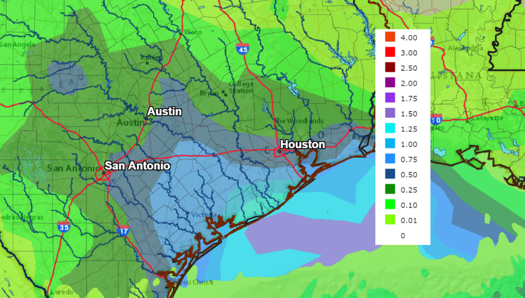
Rainfall forecasts covering the period through next Wednesday evening indicated the most favorable area for rain will be east of Interstate 35, where totals will average between a half inch and 1 inch. For areas along and west of Interstate 35, most totals are predicted to average between a quarter and a half inch. Isolated heavier downpours will be possible.
NWS Rainfall Forecast for the Period 7 pm Wednesday through 7 pm Next Wednesday:
The clouds and scattered rains should keep next week’s high temperatures around 88-90 degrees.
Bob
Social Media