After several weeks of quiet weather, the weather pattern is expected to become more active this week into next week as a series of cold fronts and storm systems move across the area. Of special note, the cold front on Friday looks to bring our region its best shot at widespread rain since early September. While cooler temperatures are on the horizon, no arctic air is expected to make a plunge into Texas over the next two-week period.
The cold front which swept through the area on Sunday has pushed into Deep South Texas and the north central Gulf of Mexico. Southeasterly winds just above the surface helped produce widespread low clouds across the region Monday morning. These clouds will thin this afternoon, allowing for scattered sunshine. Today’s temperatures will be noticeably cooler, with highs ranging from the mid-60s across the Hill Country to the mid-70s across the coastal plains. The sky is expected to become mostly cloudy tonight. Lows Tuesday morning will generally be around 58-60 degrees.
After today’s brief cooldown, temperatures are predicted to rebound Tuesday as Sunday’s cold front returns back to the north. A trough of low pressure over the Desert Southwest is forecast to move to the central Plains states Tuesday night, helping to push another cold front into Texas. Ahead of the front, Tuesday’s weather will be partly to mostly cloudy and quite breezy. Expect southerly winds at 10-20 mph, with occasional gusts to 30 mph Tuesday afternoon. High temperatures will be around 78-80 degrees. The cold front is predicted to reach the northern Hill Country around midnight Tuesday night and spread south across Central Texas and the middle Texas coast before sunrise Wednesday. There will be a 20 percent chance for a few rain showers and isolated thunderstorms along the cold front Tuesday night once it moves past the Interstate 35 corridor. Rain amounts, if any, should total around a tenth inch or less.
Clouds will clear early Wednesday, with the sky becoming sunny. Expect northerly winds at 5-10 mph. High temperatures will range from the low 70s west to the upper 70s near the coast. Low temperatures Thursday morning will be in the low and mid-40s, with low to mid-50s expected across the coastal plains.
Thanksgiving Day weather is shaping up to be partly cloudy and quite pleasant. High temperatures will be near 78-80 degrees. Expect a light southeasterly wind at 5-10 mph.
Significant changes in our weather will begin to take place Friday and will likely continue into the weekend. Forecasts call for a large trough of low pressure to develop south into Desert Southwest Friday, with the trough slowly lifting up to the northeast Friday night into Sunday. In advance of the trough and its associated cold front, considerable moisture will spread north into Texas, resulting in a very moist atmosphere. Increasing atmospheric lift will lead to the development of scattered rain showers and thunderstorms across the region Friday. The probability for rain will be near 50 percent. The most favorable period for rain and thunderstorms is forecast to take place Friday night into early Saturday morning when a cold front pushes south through the area. Some of the thunderstorms may be strong. Periods of overrunning showers look to persist Saturday into Sunday morning, with the rain then tapering off from west to east Sunday morning into Sunday afternoon. High temperatures Saturday will be in the low and mid-60s. Lows Sunday morning will range from the upper 30s across the Hill Country to the mid-40s across the coastal plains.
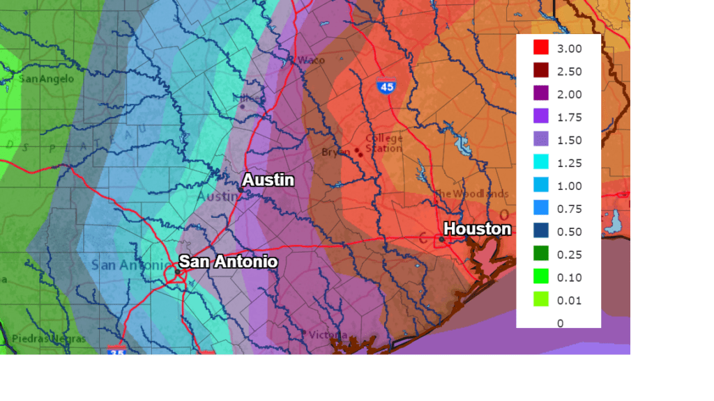
Forecasts call for widespread rain to spread across our region between Friday morning and Sunday afternoon, with the highest totals occurring along and east of Interstate 35. Totals through Tuesday are predicted to average around 1-1.5 inches across the Hill Country, around 1.5-2 inches across Central Texas and between 2 and 3 inches for the coastal plains region.
NWS Rainfall Forecast for the Period 6 pm Tuesday through 6 pm next Tuesday:
Cloudy and cool weather will be in place Sunday. High temperatures will be in the low to mid-60s. Lows Monday morning will range from the upper 30s across the Hill Country to the mid-40s near the coast.
Sunny, dry and cool weather is forecast next Monday and Tuesday. High temperatures look to be in the low to mid-60s while low temperatures will be in the upper 30s to mid-40s.
Long-range forecast call for a chance for rain to develop across our region the second half of next week when another large trough of low pressure sinks into the Southwestern U.S. and then slowly moves to the east, setting up an overrunning pattern. High temperatures will remain on the cool side with highs in the 60s and lows in the 40s.
Tropical Weather Outlook
National Hurricane Center forecasters are monitoring a broad area of low pressure located a few hundred miles northeast of the central Bahamas. This system continues to produce disorganized cloudiness and showers well to the northeast and east of its center. Strong upper-level winds are expected to limit additional development of the system before the low merges with a cold front on Tuesday. Later in the week, the system could become separated from the front and it might develop some subtropical characteristics while it meanders over the central Atlantic. NHC forecasters give this system a 20 percent chance for subtropical development over the next 5 days.
Elsewhere, conditions are quiet and tropical cyclone development is not expected.
Evening Views of the International Space Station Continue this Week
There will be more opportunities to view the International Space station flying overhead Thursday, Friday and Saturday evenings this week. Check out NASA’s “Spot the Station” webpage to view the times for your specific area. https://spotthestation.nasa.gov/home.cfm
Bob
Social Media