The historical outbreak of arctic air which has gripped Texas for more than a week is finally on its way out. The large trough of low pressure over the central US that has enabled bitterly cold air to spread south into Texas for the past week is finally lifting off to the northeast. This will in effect shut the door on any additional surges of arctic air. This weekend, a developing ridge of high pressure over the southern US will cause warmer and more stable weather pattern that looks to continue through the first half of next week.
Outlook
Friday started off quite cold with minimum temperatures in the low and middle teens across the Hill Country, the mid and upper teens across Central Texas and the mid-20s across the coastal plains. Midday satellite images showed a clear sky across all of Texas as stable ridge of high pressure was beginning to take hold of the weather pattern. Under bright sunshine this afternoon, temperatures are predicted to warm above freezing at all locations, finally causing a widespread thaw. Today’s temperature is forecast to peak around 40 degrees across the Hill Country and Central Texas and in the mid-40s towards the coast. Expect a light northeasterly breeze at 5-10 mph. A Pacific cold front is forecast to push across the area late Sunday, bringing just slightly cooler air for Monday. No rain is expected with the cold front. Warmer temperatures will arrive for Tuesday and Wednesday.
We will be looking at one more very cold night Friday night as the sky remains clear and winds are light. Lows Saturday morning are predicted to be around 20 degrees across the Hill Country and Central Texas and in the low to mid-20s across the coastal plains.
Saturday’s weather will be sunny. A southerly breeze at 10-15 mph is forecast to develop by afternoon, causing significantly warmer temperatures. High temperatures Saturday will generally be in the low and mid-50s.
Saturday night, the temperatures is forecast to remain above freezing at all locations! Expect the sky to become mostly cloudy. Lows Sunday morning will generally be in the upper 30s, with low to mid-40s expected towards the coast.
Sunday will start off with widespread low clouds, but the sky is predicted to become mostly sunny in the afternoon. Warmer temperatures are forecast, with highs around 60-62 degrees. Expect a light southwesterly breeze.
For Monday through Wednesday, expect mostly sunny and mild weather. High temperatures will be near 58-60 degrees Monday, warming to the mid-60s Tuesday and into the low 70s on Wednesday! Lows Monday morning are forecast to be around 28-30 degrees across the Hill Country, in the mid-30s across Central Texas and in the low 40s near the coast. Lows Tuesday morning will be in the upper 30s while lows Wednesday morning will be in the upper 40s.
Forecasts call for a chance for rain to develop next Thursday when another Pacific cold front moves across the area. Rain amounts are predicted to only average around a tenth of an inch. Just slightly cooler air will follow the front Thursday into Friday. Expect high temperatures in the low 60 with low temperatures in the 40s.
Long-range forecasts call for continued mild temperatures the week of March 1st, with high temperatures generally in the 60s and lows in the 40s.
Satellite View of this Week’s Snow
With today’s clearing sky, it has given us a good view of this week’s snow cover. The following true-color visible image from 11:50 AM, shows the true extent of the snow cover across Texas (the white color is snow, not clouds).
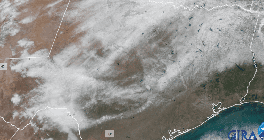
Colorado State University/RAMMB 02/19/21 11:50 am CST
Bob
Social Media