A large complex of thunderstorms which developed along the West Texas dry line Wednesday evening spread south across the Concho Valley and the western Hill Country Wednesday night, producing a large area of heavy rain. Gauge reports and Doppler radar estimates show totals of 2 to 5 inches fell over southeastern Tom Green, western Concho, eastern Schleicher and northern Sutton counties. An LCRA Hydromet gauge located 17 miles east-northeast of Sonora, in Sutton County, recorded a storm total of 4.74 inches! Another gauge located in eastern Schleicher County recorded a storm total of 2.87 inches. The heavy rain didn’t spread very far to the east. Although parts of western Kimble County saw some 1-1.5 inch totals, amounts across the rest of the Hill Country only totaled around a tenth of an inch.
Doppler Radar Estimate of Rain Falling between 10 am Wednesday and 10 am Thursday:
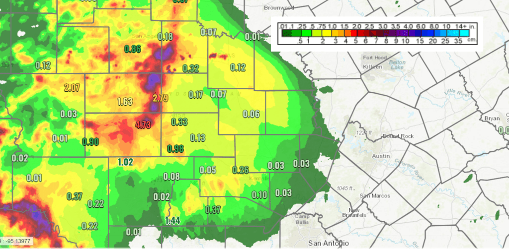
Data courtesy of NOAA/National Weather Service
A typical hot and dry summertime weather pattern set up across our region this week as a stable ridge of high pressure spread over Texas out of the Gulf of Mexico. The ridge is forecast to remain over Texas through the upcoming weekend, causing more hot and dry weather conditions. In fact, with the center of the ridge moving closer to Central Texas, temperatures are predicted to trend even hotter today, continuing through the weekend. The atmospheric conditions responsible for thunderstorm development across West Texas the past few nights have weakened, and as a result, no additional dry line thunderstorm development is expected.
- High temperatures this afternoon are forecast to reach the upper 90s across the Hill Country and Central Texas regions and the low to mid-90s across the coastal plains.
- High temperatures Friday are forecast to reach near 98-100 degrees across the Hill Country and Central Texas regions the mid-90s towards the coast.
- High temperatures Saturday and Sunday are forecast to reach near 100-102 across the Hill Country and Central Texas regions with middle 90s hanging on near the coast.
At the surface, gusty southerly winds over the past couple of days brought a very moist air mass inland, resulting high humidity levels and very uncomfortable conditions. This moist air has also helped to keep morning low temperatures near 78-82 degrees. The pressure gradient responsible for the gusty winds has weakened and as a result, lighter winds of 5-10 mph are forecast Friday and through the weekend. The air is predicted to be just a little less humid and this should allow nighttime temperatures to fall to the mid and upper 70s.
A slight chance for afternoon and evening rain showers and thunderstorms will enter the forecast next Monday through Wednesday as a weak trough of low pressure over the lower Mississippi Valley region backs west to the Texas/Louisiana border. Moisture wrapping around the trough is predicted to spread as far west as the central Hill Country. At the same time, the center of the high pressure ridge currently over Texas is forecast to shift west to the Four Corners region. With a slightly less stable atmosphere in place, a few scattered rain showers and isolated thunderstorms will be possible Monday through Wednesday. The probability for rain each day will only be 20 percent and rain amounts should average less than a quarter inch.
- High temperatures Monday through Wednesday are forecast to be in the upper 90s, with low and mid-90s expected towards the coast. Lows will be in the mid and upper 70s.
A sunny, dry and very hot pattern is predicted to develop the second half of next week, continuing into next weekend as the ridge of high pressure near the Four Corners strengthens and shifts east to the southern Plains states. As sinking air from the ridge increases, high temperatures are forecast to trend even hotter.
High temperatures Thursday and Friday are forecast to rise to near 100 degrees. High temperatures next weekend are predicted to exceed 100 degrees, near 101-103 degrees,. Readings may approach 100 degrees even across the coastal plains.
The outlook for the week of July 13th is showing little change as the high pressure ridge remains parked over the southern Plains states. Dry and very hot weather looks to continue, with high temperatures remaining near 100-102 degrees.
Saharan Dust Update
A second cloud of Saharan dust spread inland along the Texas coast late Wednesday and is forecast to bring moderate to heavy amounts of dust to Central Texas and the Hill Country this afternoon and evening. The daily PM2.5 AQI is forecast to reach the upper end of the “Moderate” range in parts of the Austin, Laredo, San Antonio, Tyler-Longview, and Victoria areas.
The Sharan dust is forecast to continue across the region Friday and the weekend with decreasing intensities.
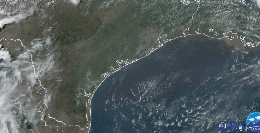
RAMMB/CIRA 07/02/20 2:40 pm CDT
Tropical Weather Outlook
Weather conditions are currently very quiet and there are no systems in place which pose a threat for tropical development over the next 5 days.
Aphelion, Jupiter and Saturn
On Saturday, the Earth will be at aphelion, or its farthest distance from the Sun for the entire year. We’ll be one part in 30 farther from the Sun than at perihelion in January.
The bright planets Jupiter and Saturn (magnitudes –2.7, and +0.2, respectively) now rise in the eastern sky during late twilight. They hang low in the southeast after dark. Jupiter is the brightest, Saturn is to the lower left of Jupiter. Farther to Jupiter’s right, you’ll find the Sagittarius Teapot resting upright. The two giant planets shine at their highest around 1 or 2 a.m. DST.
Have a safe and enjoyable Fourth of July weekend!
Bob
Social Media