Here is an update on Tropical Depression 22. The depression is predicted to be a very slow-moving system and remain over the northwestern Gulf for the next several days. Based on the latest forecast, rain from the system is forecast to spread west into Central Texas early next week. Meanwhile, extremely high totals of rain leading to widespread flooding are forecast for the coastal plains region.
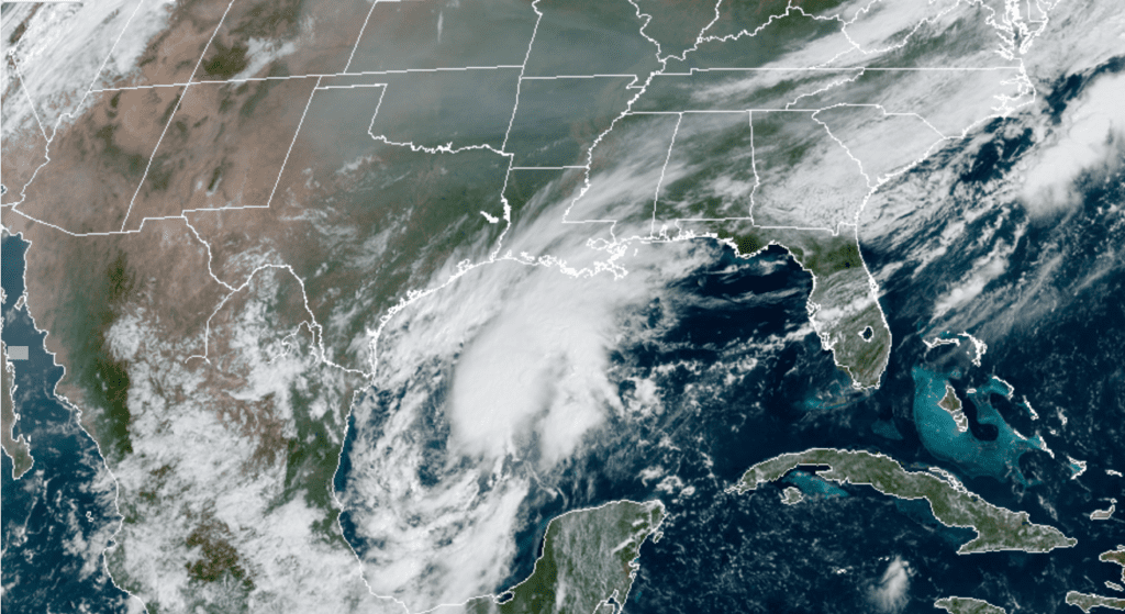
Friday morning’s satellite imagery indicated Tropical Depression Twenty-Two is getting better organized. As of 10 am CDT, the center of the depression was located in the western Gulf of Mexico, about 255 miles southeast of the mouth of the Rio Grande River. The depression was moving toward the north-northeast near 7 mph and this general motion is expected to continue through early Saturday. Maximum sustained winds were near 35 mph with higher gusts. Strengthening is forecast during the next few days, and the depression is expected to become a tropical storm later today. The system could be near or at hurricane strength by Sunday.
NOAA-RAMMB 09/18/2020 10:40 am CDT
For the next 24 hours or so, the cyclone is forecast to slowly move to the north-northeastward over the Gulf as it is steered by a mid-to upper-level trough situated over Texas and northeastern Mexico. This trough is expected to lift out to the northeast this weekend, allowing a ridge of high pressure to strengthen north of the cyclone. This should cause a westward turn at a continued slow forward speed. Forecasts indicate that around Tuesday, a mid-latitude trough over the central U.S. will cause the ridge to weaken and steer the cyclone along a slow northward to northeastward track, very close to the middle Texas coast. This is the general scenario that is forecast through early next week. However quite a few small twists and turns will likely occur along this general path.
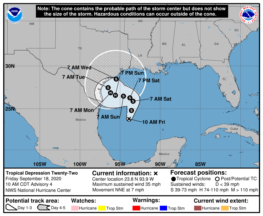
The depression is currently in an environment that is favorable for strengthening. National Hurricane Center forecasters call for the depression to become a tropical storm late today and strengthen to become a category 1 hurricane on Sunday.
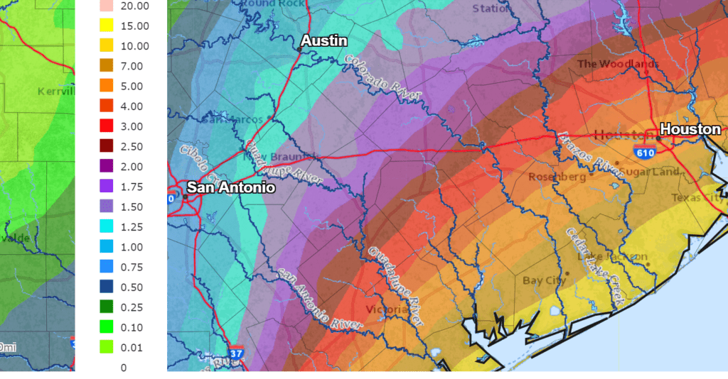
Based on the latest forecast track, bands of rain showers and thunderstorms are predicted to begin spreading inland along the middle Texas coast (Matagorda/Wharton Counties) Sunday afternoon as the cyclone starts moving back to the west. Rain showers and scattered thunderstorms are forecast to spread further inland to Central Texas, the Interstate 35 corridor and possibly the eastern Hill Country Monday, with additional rains continuing across the area Tuesday through Wednesday. The rains should taper off Wednesday into Thursday as the system moves further to the northeast. Totals of 1-2 inches are forecast through Wednesday
But with the center of the tropical cyclone/hurricane approaching and moving very slowly just offshore of the middle Texas coast between Sunday through Wednesday, there will be a potential for very high totals of rain closer to the coast. The latest 7-day Weather Prediction Center forecast calls for totals of 5-10 inches of rain for areas between Columbus and Wharton and totals of 10-15 inches for locations between Wharton and Bay City. Areas south of Bay City could see totals in excess of 15 inches!
NWS Rainfall forecast for the period 7 am Friday through 7 am next Friday:
Another coastal aspect of the tropical cyclone will be unusually high water levels leading to coastal flooding persisting through the middle of next week. A long period east and southeasterly winds off the Gulf of Mexico will cause water to begin piling up along the coast. Water levels are predicted to begin rising along the coast on Saturday and reach into warning level on Sunday. Current forecasts show tide levels reaching at least 4.0-5.0 feet above MLLW (barnacle level). Low lying roadways near the coast will likely flood at times of high tide and some locations could become isolated. Significant beach erosion is likely with elevated tides and large wave action lasting for several days. Coastal infrastructure could be damaged. It is thought the expected tides on Sunday will likely be 1.5-2.5 feet higher than those experienced with Hurricane Laura.
There will be interesting aspect to the potential naming of this system. Tropical Storm Wilfred in the eastern tropical Atlantic was named Friday morning, taking the last name on the list for the 2020 season. Also Friday morning, sub-tropical storm Alpha was named for a system off the coast of Portugal. Therefore, if and when the depression off the Texas coast gets upgraded to a tropical storm, it will likely take on the name of “Beta”, the second letter of the Greek alphabet.
I urge everyone to keep a close watch on further developments as we head into the weekend. I plan to pass along additional updates.
Bob
Social Media