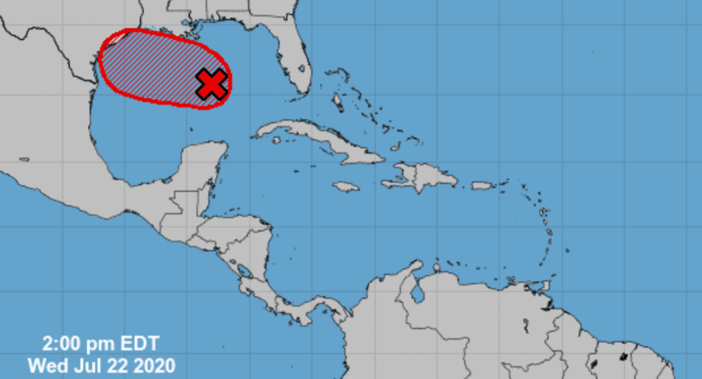
National Hurricane Center forecasters continue to keep a close eye on a strong tropical wave located now over the eastern Gulf of Mexico. Satellite wind data Wednesday afternoon indicated a broad low pressure area has formed in association with the tropical wave over the central Gulf of Mexico. The system is producing a large area of disorganized showers and thunderstorms over the eastern Gulf, central and southern Florida, and western Cuba. Conditions appear conducive for additional development, and a tropical depression is likely to form Thursday or Friday as the system moves west-northwestward at about 10 mph. The disturbance is expected to reach the northwestern Gulf Thursday into Friday. NHC forecasters are giving this system a 80 percent chance for tropical development over the next 5 days.
The global forecast model solutions call for the tropical disturbance to push inland somewhere along the middle Texas coast sometime Saturday. Do note these latest solutions are a bit slower with the overall motion, compared to previous forecasts.
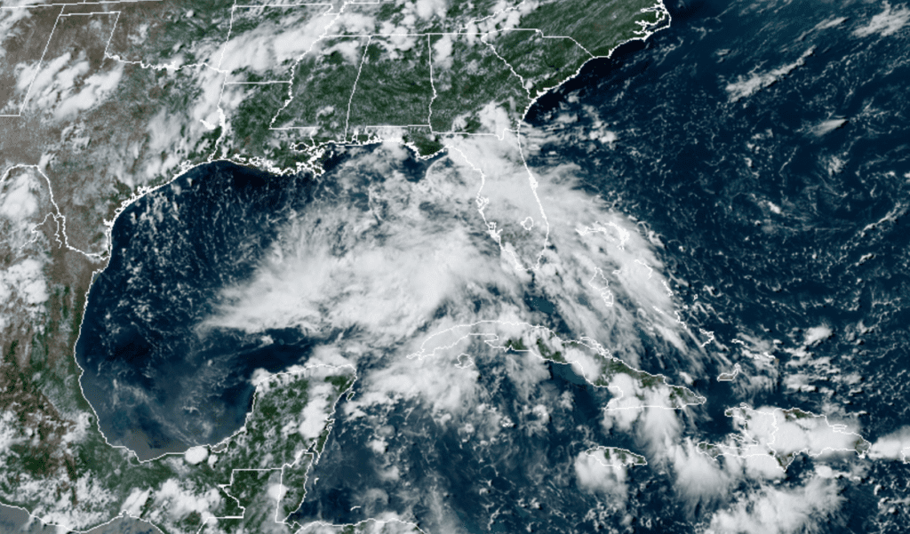
RAMMB-CIRA 3:30 pm 07/22/2020
Based on the latest forecast guidance, a large slug of tropical moisture will begin spreading inland along the middle Texas coast Friday, with the moisture then spreading northwest across Central Texas and Hill Country regions Friday night, continuing through the weekend. Increasing moisture combined with increasing atmospheric lift associated with the wave/disturbance is expected to produce a widespread area of rain showers and scattered thunderstorms reaching the middle Texas coast Friday afternoon and evening, with the rain area gradually spreading into Central Texas and the Hill Country Friday night into Saturday morning.
Forecasts call for a widespread coverage of rain across the entire region Saturday through Sunday as the disturbance tracks to the west. Moderate to heavy rain will be possible—especially for areas from the Interstate 35 corridor, southeast to the coast. A fairly good coverage of rain and thunderstorms looks to continue across the area Monday, with the rain becoming more scattered Tuesday into Wednesday.
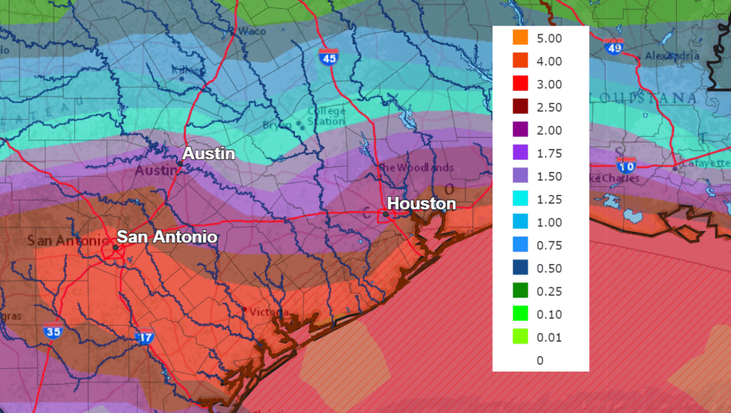
The latest National Weather Service rainfall forecast calls for much of the area to see a good soaking of rain this weekend. Widespread totals of 1-3 inches are forecast for the area between Austin and the coast. Lower totals are forecast across the Hill Country. Near the coast, totals of 3-5 inches are predicted. Keep in mind that due to the tropical nature of this system, there will be the potential for even higher totals.
NWS Rainfall Forecast for the Period 7 pm Wednesday through 7 pm Wednesday:
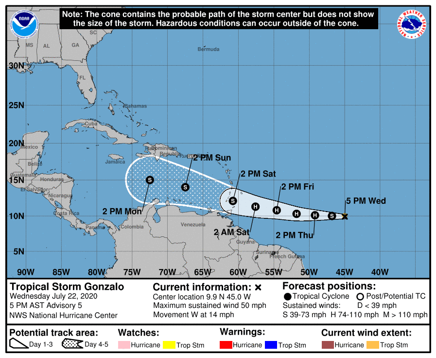
Tropical Storm Gonzalo
The tropical depression which developed over the central Tropical Atlantic Tuesday strengthened and organized Wednesday morning to become Tropical Storm Gonzalo.
As of 4 pm CDT Wednesday, the center of Tropical Storm Gonzalo was located in the central tropical Atlantic, about 1110 miles east of the southernmost Windward Islands. Gonzalo is moving toward the west near 14 mph. A general westward motion at a faster forward speed is expected during the next few days. On the forecast track, the center of Gonzalo will approach the Windward Islands late Friday and Saturday.
Maximum sustained winds are near 50 mph with higher gusts. Strengthening is forecast during the next couple of days, and Gonzalo is expected to become a hurricane by Thursday.
The National Hurricane Center forecast for Gonzalo calls for the storm to track west-northwest through the eastern Caribbean Sea this weekend, reaching a position south of Hispaniola on Monday. It is much too early to tell where the system will go from there. Interestingly, most of Wednesday’s global models call for the system to weaken or dissipate early next week as the storm moves into a very unfavorable environment. However, there are some solutions showing the system surviving the hostile environment.
We will need to keep a close watch on the progress of Gonzalo.
Bob
Social Media