Here is an update on Tropical Storm Hanna and Tropical Storm Gonzalo, based on Friday afternoon’s data. Hanna is predicted to make landfall near or south of Corpus Christi on Saturday. Widespread rains are forecast across Central and South Texas this weekend, with additional scattered rains expected the first half of next week. Tropical Storm Gonzalo is predicted to move across the southern Windward Islands this weekend and move into the eastern Caribbean sea early next week. Forecasts call for Gonzalo to dissipate early next week, not posing a threat to the western Gulf.
Tropical Storm Hanna
…A Hurricane Warning is in effect for Baffin Bay to Mesquite Bay Texas…
…A Tropical Storm Warning is in effect from the Mouth of the Rio Grande to Baffin Bay and from Mesquite Bay to San Luis Pass Texas…
Data from a NOAA reconnaissance aircraft, satellite data and ship reports indicate Hanna continues to organize and strengthen. As of 4 pm CDT, Hanna was centered about 195 miles east of Corpus Christi. Hanna was moving toward the west-northwest near 10 mph, and this motion should continue through Saturday morning. A gradual turn toward the west-southwest is expected Saturday night and that motion should continue through Sunday. Maximum sustained winds are near 50 mph with higher gusts. Steady strengthening is forecast for the next 24 hours, and Hanna is expected to become a hurricane before the cyclone makes landfall. Steady to rapid weakening is expected after Hanna moves inland.
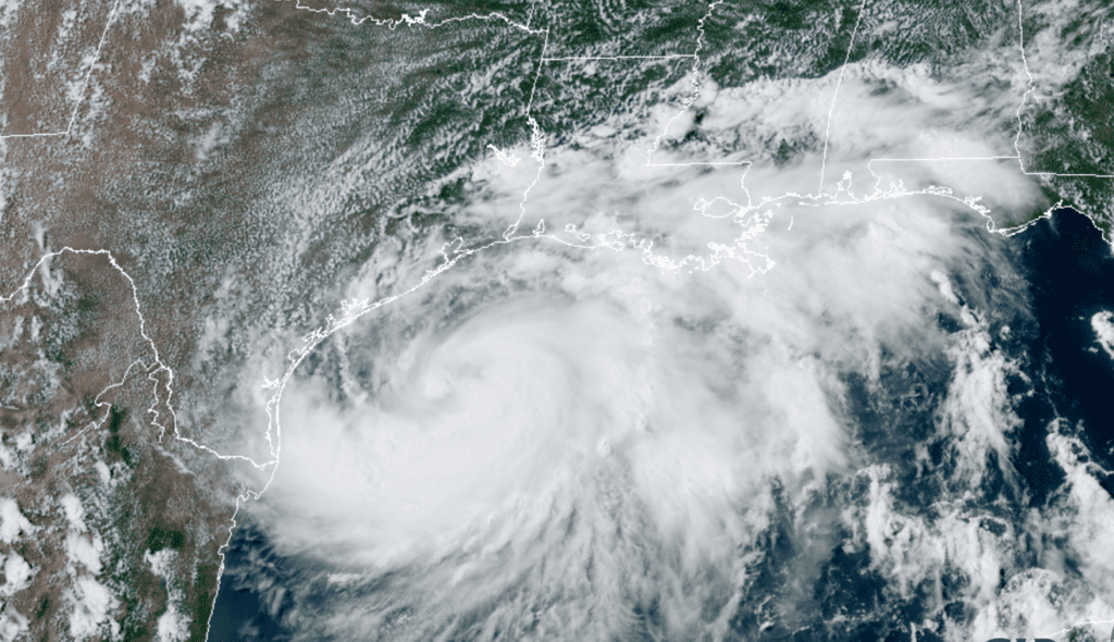
RAMMB-CIRA 07/24/2020 3:20 pm CDT
The National Hurricane Center’s forecast track calls for the center of Hanna to make landfall somewhere along the lower Texas coast Saturday afternoon. The cone of uncertainty stretches from roughly Rockport to Raymondville, with landfall most likely close to Baffin Bay, just south of Corpus Christi. NHC forecasts indicate Hanna could briefly reach hurricane intensity before making landfall. Once inland, the center of Hanna is forecast to track to the west-southwest over South Texas late Saturday into Sunday, then move into northeastern Mexico late Sunday.
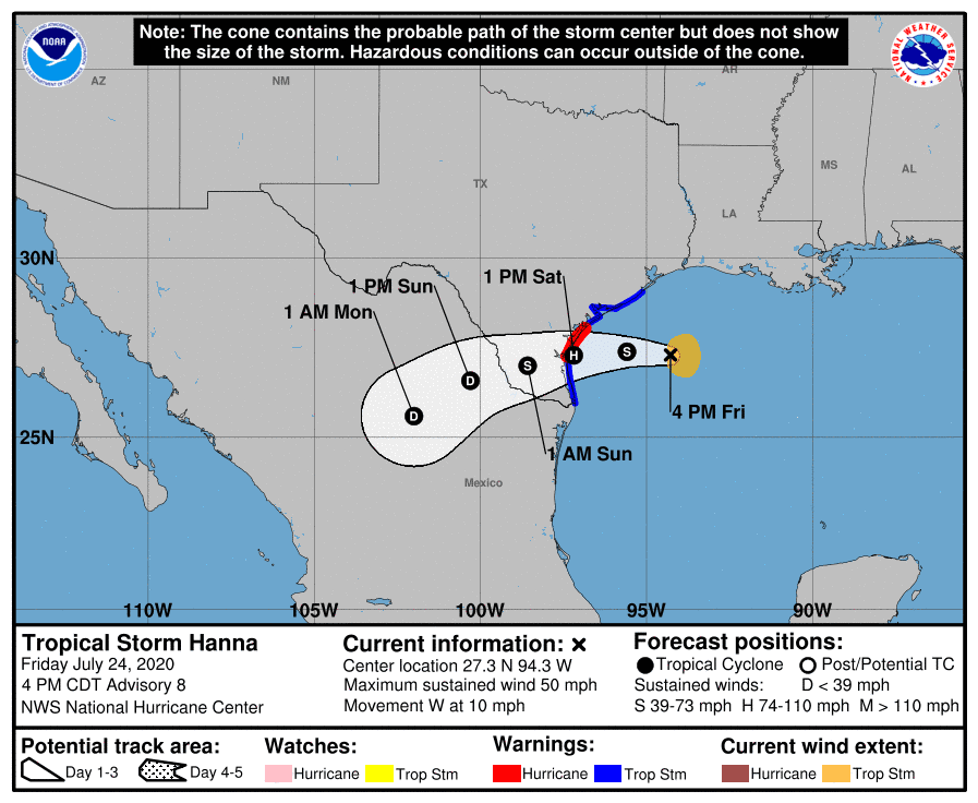
Although Hanna is predicted to track inland along the lower Texas coast, the storm is still expected to impact weather conditions from the middle coast to the Hill Country this weekend and early next week.
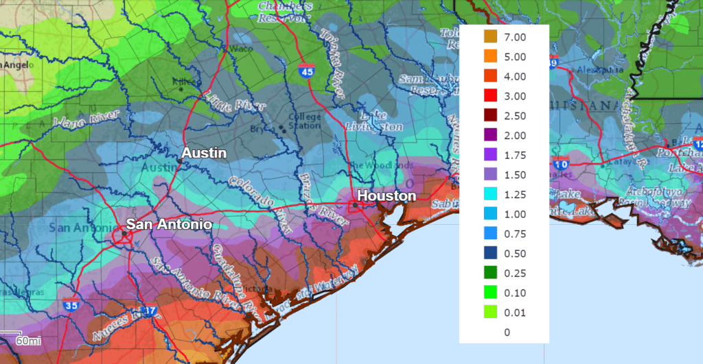
For Wharton and Matagorda Counties: A Flash Flood Watch has been posted through 7 am Sunday morning. Forecasts call for outer rain bands from Hanna to begin spreading inland this afternoon, with additional rain and thunderstorms continuing Friday evening through Friday night. Some of this rain may at times be heavy. Considerable moisture is forecast to continue spreading inland over the weekend, leading to a good chance for rain and thunderstorms Saturday through Sunday. Periods of heavy rain will be possible. Rainfall through Monday morning is forecast to generally total between 4 and 6 inches, with isolated totals to near 8 inches possible. Flooding and flash flooding will be possible.
For the Austin/Central Texas region: There will be 50 percent chance for rain showers and thunderstorms across the La Grange/Columbus Friday night. Closer to Austin, there will be just a 20 percent chance for rain showers and thunderstorms Friday tonight. Periods of rain showers and thunderstorms are forecast across the area Saturday morning through Sunday evening. Some of the rain may be heavy at times. Rainfall through Monday morning is forecast to generally average between 1 and 1.5 inches, with isolated heavier totals. The probability for rain both days will be near 70 percent.
For the Hill Country region: Weather conditions are forecast to remain overnight. Scattered rain showers and thunderstorms are forecast to develop Saturday morning, with periods of rain and thunderstorms continuing through Sunday afternoon. The probability for rain both days will be near 30-40 percent. Rainfall through Monday morning is forecast to generally average 0.5 and 1 inch.
NWS Rainfall Forecast for the Period 7 pm Friday through 7 pm Monday:
The outlook for next week calls for a continued chance for mainly afternoon and evening scattered showers and thunderstorms Monday through Wednesday as considerable tropical moisture continues to spread in from the Gulf. The probability for rain will be near 50 percent Monday, 30 percent Tuesday and 20 percent on Wednesday. Rain amounts Monday through Wednesday are forecast to average around a half inch, with isolated totals of 1-2 inches possible. High temperatures will be in the mid-90s.
There will be just a slight chance for rain late next week and next weekend as moisture levels begin to dry out. A typical summertime pattern looks to return with high temperatures near 98-100 degrees.
Tropical Storm Gonzalo
As of 4 pm CDT, the center of Tropical Storm Gonzalo was located about 390 miles east of the southern Windward Islands. Gonzalo was moving toward the west near 18 mph. A general westward to west-northwestward motion is expected for the next couple of days. On the forecast track, Gonzalo will move across the southern Windward Islands Saturday afternoon or evening and over the eastern Caribbean Sea on Sunday.
Data from an Air Force Reserve Hurricane Hunter aircraft indicated that Gonzalo’s maximum sustained winds had decreased to near 40 mph with higher gusts. Some slight strengthening is possible before Gonzalo reaches the southern Windward Islands. Weakening is expected after Gonzalo moves over the eastern Caribbean Sea and the system is forecast to dissipate early next week.
And Yet Another Tropical Disturbance has Developed
Forecasters are monitoring a strong tropical wave in the far eastern tropical Atlantic, about 300 miles southeast of the Cabo Verde Islands. This system is producing an area of cloudiness and disorganized thunderstorms. The disturbance is expected move westward across the tropical Atlantic during the next several days, and some gradual development of this system is possible by early next week when it reaches the western tropical Atlantic. NHC forecasters are giving this system a 40 percent chance for development over the next 5 days.
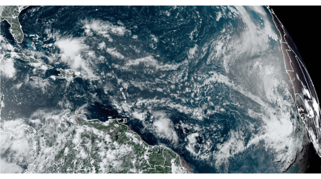
RAMMB-CIRA 12:40 pm CDT
Have a good weekend.
Bob
Social Media