A much colder and wet weather pattern developed over the weekend as a series of cold fronts brought in progressively colder air. An overrunning pattern set up Friday into Saturday night, bringing the first widespread rain in nearly two months to the entire region. Totals were lowest across the western and northern Hill Country where amounts generally averaged around a quarter inch. Across the eastern Hill Country and the Austin area, totals were mostly around a half inch. Between Bastrop and Columbus, totals were generally between 1 and 2 inches. Amounts were much higher south of Interstate 10, where totals averaged between 3 and 5 inches. Even higher totals occurred from just east of Columbus and Wharton, extending east to Houston and Beaumont, where amounts of 8-10 inches were recorded. An LCRA Hydromet gauge located at East Bernard, along the San Bernard River in northeastern Wharton County, recorded a weekend total of 8.38 inches!
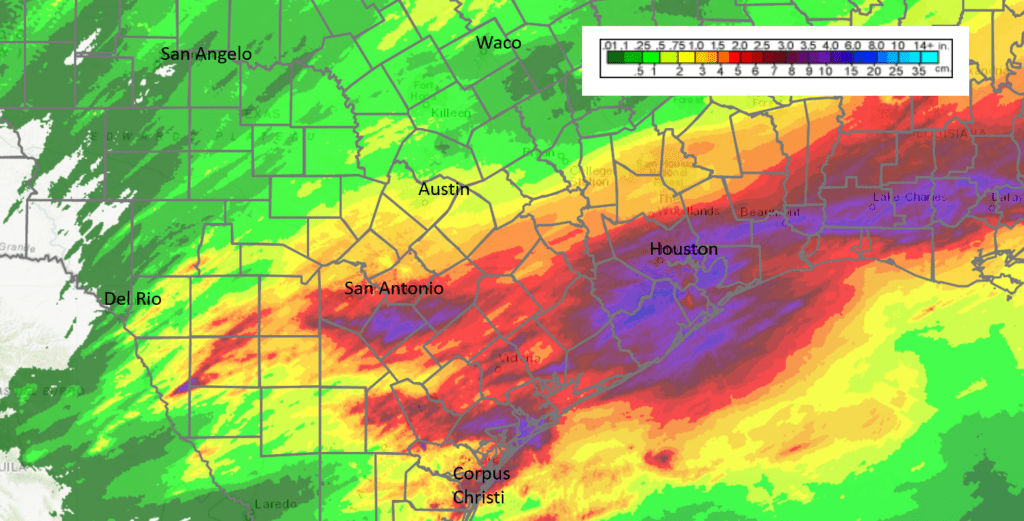
Data Courtesy National Weather Service , (9 am Friday through 9 am Monday)
Sunny and cold weather is in place across Central and South Texas as we start off the new week. A strong cold front moved across the region this morning, bringing in additional cold air. A large dome of Canadian high pressure is sinking south out of the southern Plains states behind the cold front. A moderate pressure gradient associated with the high pressure system is causing strong northerly winds. Wind speeds of 15-25 mph are forecast to persist through late afternoon, then diminish to around 5 mph hour shortly after sunset. Despite abundant sunshine, today’s temperature will stay chilly, with readings peaking in the mid-50s.
The combination of a clear sky, light winds and a cold Canadian air mass will cause the temperature to fall below freezing across all of the region, including the coastal plains, early Tuesday morning. In fact, a hard freeze is predicted for the Hill Country and most of Central Texas. The National Weather Service has posted a Freeze Warning for the Central Texas and coastal areas from mid-evening Monday through mid-morning Tuesday. Actions should be taken to protect tender vegetation. Make sure outdoor pets will have a warm place to stay overnight.
- Lows Tuesday morning will include the low and mid-20s across the Hill Country, the mid and upper 20s across Central Texas and be near 30-33 degrees across the coastal plains region.
Sunny and a little warmer weather is forecast Tuesday as the cold, Canadian air mass quickly moves off to the east. Forecasts call for a large trough of low pressure to sink south out of the central Rockies Tuesday afternoon into Wednesday. In advance of the approaching trough, southerly winds will increase across our region to a range of 10-15 mph, with occasional gusts to 25 mph Tuesday afternoon. Tuesday’s temperature will warm to the low 60s. Lows Wednesday morning will include the upper 30s across the Hill Country, the low 40s across Central Texas and the low 50s near the coast.
Clouds and moisture will spread north from the Gulf to areas east of Interstate 35 Tuesday night. Across the coastal plains region, a few rain showers and even an isolated thunderstorm or two are expected after midnight Tuesday night, continuing through Wednesday. For other locations, no rain is forecast Tuesday night. A cold front associated with the approaching trough is forecast to push southeast across the Hill Country and the Interstate 35 corridor regions Wednesday morning. No rain is forecast across the Hill Country. However, a few rain showers will be possible from the Austin area, southeast to coast as the front runs into an area of higher moisture. The chance for rain should diminish from west to east Wednesday afternoon as the cold front sinks south to the coast. Rain amounts across Central Texas are predicted to total well below a quarter inch. Across the coastal plains, totals are predicted to average around a half inch. High temperatures Wednesday will range from the mid-50s west to the mid-60s near the coast.
A light freeze is forecast across the Hill Country Wednesday night. Lows Thursday morning will be around 28-32 degrees across the Hill Country, the mid-30s across Central Texas and around 38-40 degrees across the coastal plains. Thursday’s weather will be mostly sunny and cool with high temperatures in the low and mid-50s.
A freeze is predicted for the Hill Country and Central Texas regions Thursday night. Lows Friday morning will include the mid and upper 20s across the Hill Country, be around 30-32 degrees across Central Texas and in the mid-30s across the coastal plains.
Mostly sunny to partly cloudy and cool weather is forecast Friday through next weekend. Daily high temperatures will be in the low 60s. Lows will be in the upper 20s to low 30s across the Hill Country, the mid and upper 30s across Central Texas and be around 38-40 degrees across the coastal plains.
The outlook for next week calls for the development of an unsettled pattern through at least the first half of next week. Forecasts call for a large trough of low pressure to develop over southern New Mexico and northern Mexico this weekend, with the system remaining nearly stationary for much of next week. The trough is expected to cause overrunning clouds and periods of light rain across the region next Monday through Wednesday and possibly longer. High temperatures next week are predicted to mainly be in the low 60s, with low temperatures in the 40s.
Tropical Weather Outlook
National Hurricane Center forecasters are monitoring a large non-tropical low pressure system in the northeastern Atlantic Ocean, north of the Madeira Islands. This system is producing gale-force winds in addition to a broad region of showers and thunderstorms. This low has changed little in organization over the last 24 hours, but it could still acquire subtropical characteristics as it drifts slowly southwestward over the next day or two. Afterwards, environmental conditions are forecast to become unfavorable for further development. Regardless of subtropical development, this system will continue to produce strong winds and locally heavy rains in the Madeira Islands through Tuesday. NHC forecasters are giving this system a 40 percent chance for subtropical development over the next 5 days.
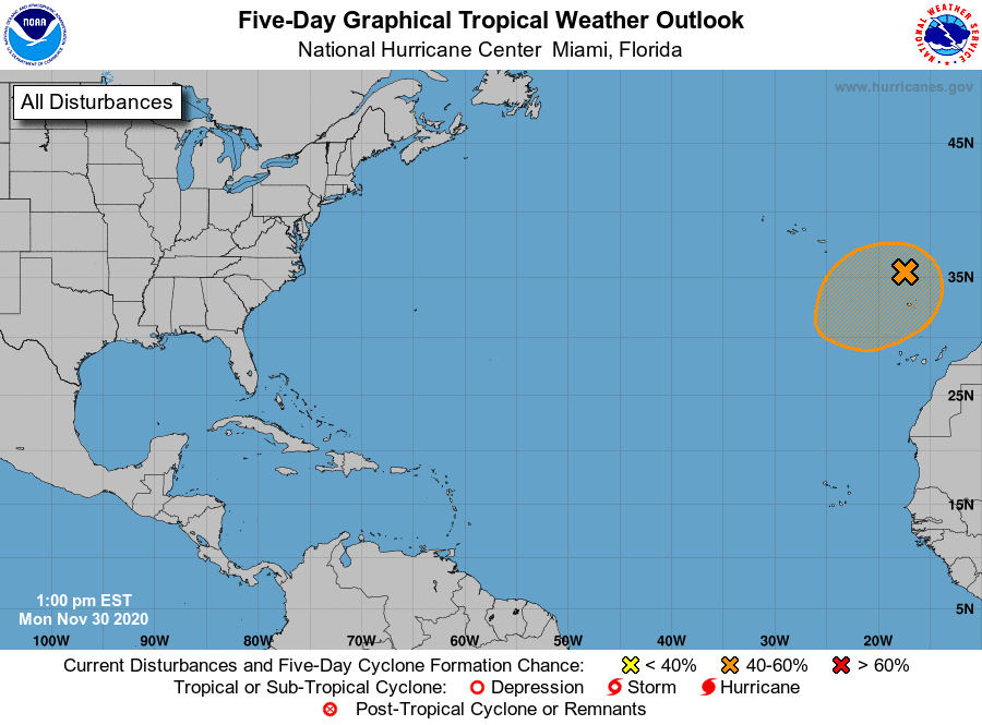
Elsewhere, weather conditions are quiet and tropical storm development is not expected.
Monday, November 30th, marks the official last day of the Atlantic Hurricane Season. The extremely active 2020 Atlantic hurricane season is drawing to a close with a record-breaking 30 named storms and 12 landfalling storms this year in the continental United States. There were 13 hurricanes and 6 major hurricanes.
Earliest Sunsets of the Year this Week
For the southern U.S. and similar latitudes, the earliest sunset of the year will occur this week, around December 2nd. In Austin, the earliest sunset will occur at 5:30 pm. The winter solstice is the shortest day of the year. It offers the shortest period of daylight. But, unless you live close to the Arctic Circle or Antarctic Circle, your earliest sunsets aren’t on or even near the solstice itself. Instead, the earliest sunsets will come well before the winter solstice.
Bob
Social Media