Our region is currently in the grips of an August heat wave. This heat wave is coinciding with what is typically the hottest point of summer for most locations across Central and South Texas. If there’s any good news to be told, it’s that temperatures are forecast to trend less hot next week as the stagnant high pressure ridge shifts northwest and a weak cold front pushes south through our region. Unfortunately, it’s still going to feel like August. We’re still several weeks away from seeing a cold front with noticeably cooler air. But hey, this is a start.
Friday’s weather maps showed a broad ridge of high pressure in the middle and upper atmosphere stretching from the West Coast to the lower Mississippi Valley. The center of the ridge has recently shifted from West Texas to southwestern New Mexico and southeastern Arizona. But despite this change in the location of the ridge center, atmospheric conditions across much of Texas remain quite favorable to produce more very hot temperatures and the weather to remain rain-free this afternoon through Sunday. In addition to the broad ridge, Friday’s maps also showed a trough of low pressure developing from the Great Lakes region to Middle Mississippi Valley region. Forecasts call for the trough to develop south to the Gulf coast this weekend and bend west into Texas early next week. It’s this trough that will allow a weak cold front to push south out of the Plains states and move into Texas late Sunday into Monday.
This afternoon through Sunday, the weather is forecast to be sunny and VERY hot! A bubble of hot air in the lower atmosphere in place over North and South Texas is predicted to sink to the surface, causing surface temperatures to soar above 100 degrees.
- For the Hill Country and Central Texas regions, high temperatures each day are forecast to be between 103 and 107 degrees. For the coastal region, high temperatures are forecast to be near 98-101 degrees.
The cold front mentioned earlier is predicted to push into North Texas Sunday afternoon into Sunday evening. Forecasts call for the front to sink south across the northern Hill Country Sunday night, reaching the Austin area Monday morning and the middle Texas coast Monday evening, The front is forecast to push as far south as the Coastal Bend Tuesday, then pull up stationary through the end of the week.
Scattered rain showers are forecast to develop along and behind the cold front Sunday evening, continuing through Monday and Tuesday afternoons as weak disturbances spread south behind the cold front. The probability for rain will be near 20 percent Sunday afternoon and Sunday night, increasing to 30 percent Monday. The probability for rain will decrease to just 20 percent Monday night and Tuesday. Dry conditions are forecast Wednesday. Rain amounts between Sunday and late Tuesday are forecast to average around a quarter inch or less. A couple of isolated totals to a half inch will be possible.
The combination of the cold front and the retreating ridge is expected to cause a slight lowering of the temperature during the first half of next week.
High temperatures Monday through Friday of next week are predicted to be near 98-101 degrees across the Hill Country and Central Texas regions and in the mid-90s across the coastal plains region. Low temperatures will be in the low and middle-70s.
The outlook for late next week, next weekend and the following week calls for few changes. The large ridge of high pressure is forecast to remain centered over the Great Basin and the Desert Southwest while a weak trough of low pressure is forecast to be across the eastern US. For our region, this means a hot, but not an extremely hot late summer pattern. Generally dry conditions are forecast late next week and next weekend. There are some indications we could see a few showers pushing in from the Gulf the week of August 24th. High temperatures are predicted to stay around 97-100 degrees across the Hill Country and Central Texas regions and in the mid-90s across the coastal plains.
Tropical Weather Outlook
Weather conditions remain quiet across the Gulf of Mexico and the Caribbean Sea. There are no systems which pose a threat for tropical development in this area over the next 5 days.
NHC forecasters continue to track Tropical Storm Josephine in the southwestern Atlantic. As of 4 pm CDT, the center of Tropical Storm Josephine was located 460 miles east of the northern Leeward Islands. Josephine is moving toward the west-northwest near 16 mph and this general motion is expected to continue for the next couple of days followed by a turn toward the northwest late this weekend or early next week. On the forecast track, the center of Josephine is expected to pass to the northeast of the Leeward Islands over the weekend.
Reports from an Air Force Reserve Hurricane Hunter aircraft indicate that maximum sustained winds are near 40 mph with higher gusts. Slight strengthening is possible tonight. After that, Josephine is expected to weaken over the weekend as it encounters unfavorable upper-level winds.
…Tropical Storm Kyle has formed over the northwestern Atlantic…
As of 4 pm CDT, the center of Tropical Storm Kyle was located about 185 miles southeast of Atlantic City, New Jersey. Kyle is moving toward the east-northeast near 17 mph. A continued east-northeastward motion with an increase in forward speed is expected for the next couple of days.
Maximum sustained winds are near 40 mph with higher gusts. Slight strengthening is possible tonight and tomorrow. Kyle is forecast to become post-tropical by late Sunday or early Monday.
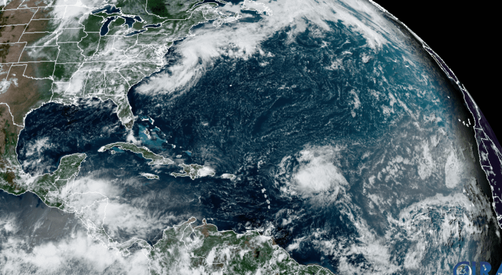
RAMMB-CIRA 08/14/2020 3 PM CDT
Catch Jupiter, Saturn and Mars this Weekend
The planets Jupiter and Saturn shine brilliantly in the south-southeastern sky in twilight. They’re highest in the south, for sharpest telescopic viewing, around 10 or 11 pm DST. Jupiter is the brightest; Saturn is 8° to its left. To the lower right of Jupiter after dark is the handle of the Sagittarius Teapot.
Mars rises in the east about an hour after the end of twilight. It emerges Sirius-bright (magnitude –1.4) and strongly orange, like a far-off bonfire. Where will it come up? Watch the horizon far below the Great Square of Pegasus. By early dawn Mars shines grandly high and bright in the south.
Have a good weekend.
Bob
Social Media