A stagnant, dangerous July heat wave continues in full force across all of Texas. Sunday was the hottest day so far this year at most locations, with readings approaching or easily exceeding the 100-degree mark. Across our region, high temperatures ranged from 105-108 degrees across the Hill Country to around 98-101 degrees across the coastal plains. Monday’s temperatures are forecast to be the same as, if not a couple of degrees warmer than Sunday’s readings as the heat wave reaches its peak.
Monday’s weather maps showed a very strong ridge of high pressure in the upper atmosphere covering northern Mexico along with the southwestern and south central U.S. The ridge was centered just west of El Paso. The atmosphere underneath the ridge remains, warm dry and quite stable. Monday’s analysis showed temperatures located a few thousand feet above the surface over Central Texas are actually slightly warmer than they were measured yesterday. As this air sinks to the surface this afternoon, it will act to push temperatures a degree or two warmer than we observed Sunday.
- Temperatures are forecast to top out this afternoon near 105-110 degrees across the western and northern Hill Country. Across the eastern Hill Country and Central Texas regions, readings look to reach near 102-107 degrees. The coastal plains region should see highs near 98-101 degrees across the coastal plains.
Forecasts call for a fairly similar weather picture Tuesday as the ridge of high pressure remains centered close to El Paso. However, temperatures a few thousand feet off the surface are predicted to be just a tad cooler and this should cause high temperatures to drop a degree or two. Wednesday through Friday, the center of the high pressure ridge is forecast to slide slowly to the northeast, reaching a position over northern Arkansas and southern Missouri by Saturday. With the ridge center lifting northeast, the current very hot temperatures are predicted to ease down slowly.
- High temperatures Tuesday will be near 105-108 degrees across the western Hill Country and near 101-104 degrees across the eastern Hill Country and Central Texas regions. Upper 90s are forecast for the coastal plains.
- High temperatures Wednesday will be near 102-105 degree across the western Hill Country and near 100-103 degrees across the eastern Hill Country and Central Texas regions. Mid to upper 90s are forecast for the coastal plains.
- High temperatures Thursday will be near 100-103 degree across the western Hill Country and near 98-101 degrees across the eastern Hill Country and Central Texas regions. Mid to upper 90s are forecast for the coastal plains.
- High temperatures Friday will be near 98-100 degree across the western Hill Country and near 98-100 degrees across the eastern Hill Country and Central Texas regions. Mid-90s are forecast for the coastal plains.
A south breeze at 10-15 mph is forecast to remain in place throughout the week.
Sunny and hot weather looks to continue this weekend as the center of the high pressure ridge remains well up to our north. A weak area of low pressure is forecast to push inland over Deep South Texas Saturday. This system will attempt to pull a little tropical moisture inland across the coastal plains region, possibly resulting in a few spotty, short-lived rain showers Saturday and Sunday. The moisture is predicted to remain south of Central Texas and the Hill Country, so the dry and hot weather will continue. Weekend high temperatures are forecast to be in the upper 90s across the Hill Country and Central Texas regions and in the mid-90s towards the coast.
The outlook for next week calls for very few changes in the hot and dry weather pattern. The center of the high pressure ridge is forecast to remain over the Middle Mississippi Valley region through late week. Spotty afternoon showers look to continue across the coastal plains region each afternoon. Some of these spotty showers may spread into parts of Central Texas late week. High temperatures are forecast to stay generally in the upper 90s, with mid-90s expected towards the coast.
There are some indications the center of the high pressure ridge may begin sliding back towards Texas the last few days of July. This could bring a return of the very hot temperatures. Stay tuned for further updates
Tropical Weather Outlook
Following the demise of Tropical Storm Fay over the weekend, conditions have returned to quiet across the tropical Atlantic, the Caribbean Sea and the Gulf of Mexico. Tropical cyclone development is not expected of at least the next 5 days.
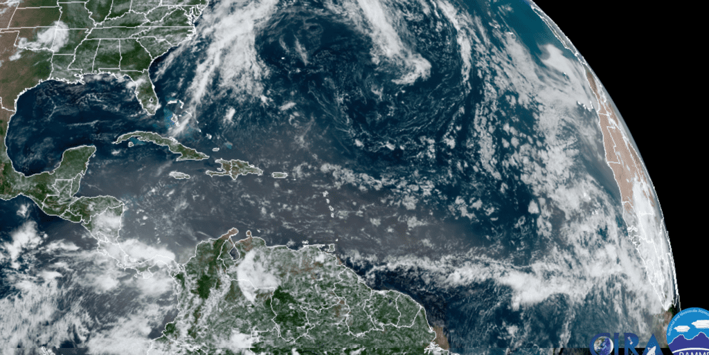
RAMMB-CIRA 07/13/20 12:30 pm CDT
Catch a View of the International Space Station all this Week
The International Space station (ISS) will be visible across the Texas sky each evening and also each morning before sunrise this week. A double treat! For the exact times and directions to spot the ISS over your area, check out NASA’s Spot the Station website, https://spotthestation.nasa.gov/
Have a good week.
Bob
Social Media