The large complex of rain and thunderstorms which moved across the Hill Country and most of Central Texas early this morning produced totals ranging from a half inch to nearly 2.5 inches. All of the rain and storms dissipated around midday. Today’s storms helped push a weak cold front to the south, with the front hanging up just north of the Interstate 10 corridor. Dry and slightly cooler air has spread into the area behind the cold front. With a more stable atmosphere in place, just a slight chance for rain and thunderstorms is forecast overnight across the Hill Country and the Interstate 35 corridor.
However, along and south of the front, a moist and moderately unstable air mass remains in place. High resolution forecast models call for an area of thunderstorms to develop along and near the boundary late this afternoon, with the activity continuing into the evening and overnight hours. (Fayette, Colorado, Wharton and Matagorda Counties) Recent forecasts suggest the developing thunderstorms will be very slow-moving, with the potential for some of the storms to train over the same area. Given the very tropical air mass in place, moderate to heavy will be possible, leading to an increasing threat for flash flooding. The threat for heavy rain is forecast to extend past midnight.
On average, totals through Wednesday morning are forecast to average between 2 and 4 inches, with isolated totals to near 6 inches possible. The National Weather Service has posted a Flash Flood Watch for Colorado, Wharton and Matagorda Counties through 7 am Wednesday.
In addition to the heavy rain threat, some of the storms may be strong to severe. The Storm Prediction Center has placed this area under a Marginal Risk (1 out of 5 risk) for severe thunderstorms overnight. The primary severe weather threat will be damaging winds.
An unsettled pattern looks to continue across the entire region through the end of the week. There will be a 50-60 percent chance for rain and thunderstorms Wednesday, Thursday and Friday. General rain amounts through Friday are forecast to average between 2 and 2.5 inches. Some scattered rain showers may continue over the weekend, but heavy rain is not anticipated. Generally dry and warm weather is forecast next week.
Tropical Storm Dolly
The subtropical depression located over the North Atlantic acquired several tropical characteristics Tuesday morning, indicating the system made the transition from being a subtropical cyclone to a tropical storm. It has now been designated as Tropical Storm Dolly. At 3 pm CDT, the center of Tropical Storm Dolly was centered about 335 miles south-southeast of Halifax, Nova Scotia. Dolly is moving toward the east-northeast near 12 mph. A turn toward the northeast with an increase in forward speed is expected tonight and on Wednesday. Maximum sustained winds are near 45 mph with higher gusts. Weakening is forecast as Dolly moves over colder waters, and the system is expected to become post-tropical on Wednesday. The remnant low should then dissipate by early Thursday.
Saharan Dust Update
Tuesday’s satellite images reveal the large cloud of Saharan Dust spreading west across the tropical Atlantic has now moved past the Yucatan Peninsula. Forecasts call for the area of dust to turn to the northwest and should reach the lower and middle Texas coast by Wednesday afternoon and into Central Texas by Thursday morning. According to the TCEQ, depending on the intensity and coverage of the Saharan dust along with scattered precipitation, the daily PM2.5 Air Quality Index (fine particulate matter) is forecast to reach the middle to upper end of the “Moderate” range in parts of the Austin, Houston, Laredo, Midland-Odessa, San Antonio, and Victoria areas on Thursday.
On Friday, the TCEQ is forecasting the PM2.5 AQI index to reach the middle to upper end of the “Moderate” range in parts of the Amarillo, Austin, Beaumont-Port Arthur, Big Bend, Dallas-Fort Worth, El Paso, Houston, Midland-Odessa, San Antonio, Victoria, and Waco-Killeen areas. Dusty conditions are forecast to continue through the weekend.
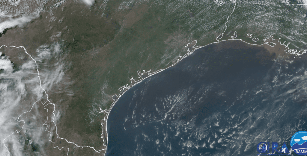
RAMMB-CIRA 06/23/20 1:00 pm CDT
Depending on weather conditions late week and through the weekend, our region may see the sky turn milky white and our sunsets and sunrises become very colorful.
Bob
Social Media