Although we are in the last few days of astronomical summer, temperatures look to be more typical of July and August this weekend and early next week. Even though we had a fairly mild summer, the autumn pattern seems to be having a hard time getting started this year. However, a cold front moving through the region the middle of next week is expected to bring a small taste of fall-like weather for the second half of next week. This won’t be sweater weather, but it will be enough to note a change in the air.
Friday’s weather maps showed a broad ridge of high pressure in the upper atmosphere covering northern Mexico and the Southwestern U.S. This feature is predicted to remain in place through early next week, producing more widespread summer-like weather across Texas. In addition to the ridge, Friday’s maps also showed a small low pressure area over northeast Texas. This system is forecast to track south across East Texas over the weekend and have the potential to spark the development of a few scattered rain showers and thunderstorms across the eastern counties of Central Texas and the middle Texas coast Saturday and Sunday–generally for areas along and east of U.S. Highway 77. The probability for rain will be near 30 percent. For areas that do happen to see rain, totals are forecast to average around a quarter inch or less. Meanwhile, mostly sunny and dry weather is forecast for the Hill Country and most of Central Texas through Sunday.
- High temperatures Friday through Sunday are forecast to be in the mid-90s, with low 90s expected towards the coast.
Mostly sunny, dry and hot weather is forecast across the region Monday as the area of low pressure exits to the east. High temperatures are forecast to reach the upper 90s across the Hill Country, the mid to upper 90s across Central Texas and the low to mid-90s across coastal plains.
Some changes in the weather pattern are forecast to take place Tuesday when a large trough of low pressure dives southeast out of the northern Rockies, pushing the stagnant ridge further to the west. The advancing trough is expected to help push a cold front south into Texas. Forecasts call for the cold front to reach Northwest Texas early Tuesday morning, the northern Hill Country around midday and the Austin area in the late afternoon. The front is forecast to continue pushing southeast and move off the middle Texas coast just after sunrise on Wednesday.
Atmospheric conditions appear somewhat favorable for an area of rain showers and scattered thunderstorms to develop along and behind the cold front when it moves across the Hill Country and Central Texas regions Tuesday afternoon and Tuesday night. Across the coastal plains, the chance for rain will occur Tuesday night into Wednesday morning. The probability for rain at any given location will be near 30 percent. Totals are predicated to generally average around a quarter inch. High temperatures in advance of the cold front on Tuesday are precited to be in the mid-90s.
Mostly sunny, less hot, less humid and almost fall-like air can be expected behind the cold front Wednesday and Thursday. High temperatures both days are forecast be in the mid and upper 80s.
- Low temperatures Wednesday morning will range from the low 60s across the Hill Country to the low 70s near the coast.
- Low temperatures Thursday morning will range from the mid and upper 50s across the Hill Country, to the upper 50s to low 60s across Central Texas to the low and mid-60s near the coast.
Sunny, dry and slightly warmer weather is forecast Friday through next weekend. High temperatures are forecast to warm back close to 90 degrees, with low temperatures mostly in the mid and upper 60s.
Looking out into the week of September 27th, forecasts call for mostly sunny and warm weather the first half of the week, with high temperatures near 90-92 degrees. We may see the development of some showers the second half of the week as moisture returns off the Gulf of Mexico. Little change in the temperature is expected.
Tropical Weather Outlook
Weather conditions across the Gulf of Mexico and the Caribbean Sea are quiet and there are no features in place which pose a threat for tropical development over the next few days. The remnants of Nicholas were located Friday morning over central Louisiana, about 65 miles south-southeast of Shreveport. The remnants were moving to the north at 7 mph and are forecast to move to the Middle Mississippi Valley region this weekend.
National Hurricane Center forecasters are monitoring an area of low pressure located about 150 miles east of Cape Hatteras, North Carolina. The circulation associated with this system remains broad and elongated, and most of the associated shower and thunderstorm activity is displaced well to the north and east of the center. However, this system is still likely to become a short-lived tropical depression or tropical storm before it makes a transition to a non-tropical gale-force low by Saturday or Saturday night while moving northeastward at about 15 mph away from the United States mid-Atlantic and Northeast coasts. NHC forecasters are giving this system a high chance, a 70 percent chance, for tropical development over the next 2 days.
Showers and thunderstorms remain disorganized in association with a tropical wave and broad area of low pressure located about midway between the Lesser Antilles and the Cabo Verde Islands. However, environmental conditions are expected to be conducive for development during the next few days, and a tropical depression is still likely to form over the weekend or early next week while moving toward the west-northwest at 15 to 20 mph across the central tropical Atlantic and then near or north of the Leeward Islands by Monday and Tuesday. NHC forecasters are giving this system a high chance, a 70 percent chance, for tropical development over the next 5 days.
Finally, disorganized cloudiness and thunderstorms over the far eastern tropical Atlantic are associated with a tropical wave are located a couple of hundred miles southeast of the Cabo Verde Islands. Environmental conditions are forecast to be only marginally conducive, and development, if any, of this system should be slow to occur over the next few days while it moves toward the west-northwest or northwest at 5 to 10 mph over the far eastern Atlantic. NHC forecasters are giving this system a low chance, a 20 percent chance, for tropical development over the next 5 days.
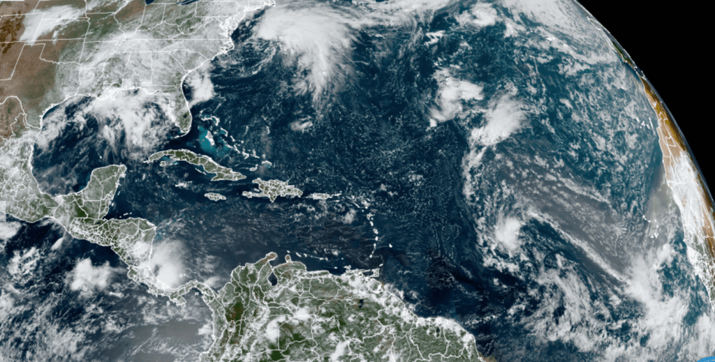
NOAA/Colorado State University/RAMMB 09/17/21 12:20 pm CDT
A Warm September
September so far has been very summer-like, with daily temperatures in the 90s and low in the 70s. Readings through the middle of the month have been averaging between 1 and 2 degrees above normal across the entire region. In Austin, Camp Mabry has reported an average temperature of 84.6 degrees, which is 2 degrees above normal. The period September 1-16 ties with 1999 and 1972 for the 10th warmest such period on record. The warmest September 1-16 occurred just two years ago, when the average temperature in Austin was 88.1 degrees.
Enjoy this last weekend of summer!
Bob
Social Media