Hurricane Delta Update
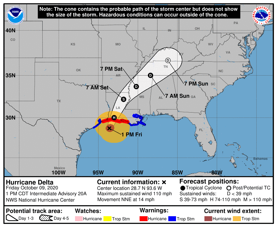
Although Delta has weakened some since sunup, Delta remains a dangerous category 2 hurricane. As of 3 pm CDT, the center of Hurricane Delta was located about 50 miles south of Cameron, Louisiana. Delta was moving to the north-northeast at 14 mph and this motion should continue through Saturday morning. Maximum sustained winds were near 105 mph, with higher gusts. Delta is a category 2 hurricane on the Saffir-Simpson Hurricane Wind Scale. Slow weakening is expected before landfall, with rapid weakening expected after the center moves inland.
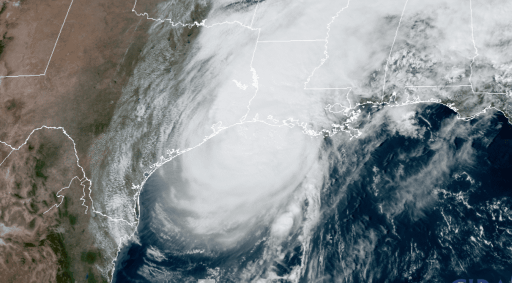
RAMMB-CIRA/Colorado State U 10/09/2020 2:00 pm
On the latest forecast track, the center of Delta should make landfall along the coast of southwestern Louisiana sometime late Friday afternoon or evening then move across central and northeastern Louisiana Friday night and Saturday morning. Interestingly, Delta is predicated to make landfall very close to the same location where Hurricane Laura made landfall just 6 weeks ago.
Early Friday afternoon, rain bands associated with Hurricane Delta were spreading inland along the upper Texas coast, between Galveston and Port Arthur. A few spotty light showers have been reported across parts of Wharton and Matagorda Counties this morning, but totals so far have been less than a tenth of an inch. There will be a 40 percent chance for additional light showers across the middle Texas coast this afternoon, with the rain tapering off this evening. Totals should average around a tenth of an inch or less. Coastal areas will see northeasterly winds at 20-25 mph this afternoon, but wind speeds should decrease to around 5-10 mph this evening and overnight. Clouds along the western periphery of the hurricane are expected to keep today’s sky mostly cloudy.
For the Central Texas and Hill Country, no direct impacts from Delta are expected this afternoon or tonight. There will be a 20 percent chance for a few spotty light showers for areas southeast of Austin this afternoon. Otherwise, this afternoon’s weather is expected to be partly cloudy and warm with high temperatures generally in the middle 80s. Expect a light northeasterly wind at 5-10 mph.
This weekend, a mostly sunny, hot and summer-like weather pattern is forecast to develop across much of Texas as the remnants of Delta track northeast to the Mississippi and Tennessee Valleys. The combination of strong high pressure building over the state and southwesterly breezes is expected to push afternoon temperatures both days well into the 90s.
- High temperatures Saturday will include the middle 90s across the Hill Country and Central Texas regions and the lower 90s across the coastal plains region.
- High temperatures Sunday are forecast to be near 98-100 degrees across the Hill Country, be in the mid and upper 90s across Central Texas and be the low to mid-90s across the coastal plains.
A Pacific cold front is predicted to track southeast across Texas Monday, bringing in slightly cooler air. The front is forecast to spread across the Hill Country Monday morning and push off the middle Texas coast Monday evening. Atmospheric conditions will be too dry for any rain along the front. High temperatures Monday will be near 88-90 degrees across the Hill Country, in the low to mid-90s across Central Texas and the lower 90s towards the coast.
Sunny, dry and warm weather is forecast Tuesday through Thursday as our region remains under the influence of a weak ridge of high pressure. Daily high temperatures are predicted to be in the mid and upper 80s. Low temperatures will range from the mid and upper 50s across the Hill Country to the low and mid-60s near the coast.
Forecasts call for another cold front to sweep across our region next Friday, bringing another push off cooler air. Once again, the atmosphere is expected to be too dry for any rain to develop along the front. Sunny and dry weather is forecast Friday and next weekend. High temperatures will be in the low and mid-80s with low temperatures in the upper 50s to low 60s.
Looking out into the week of October 19th, forecasts call for few changes in the weather pattern. Mostly sunny and dry weather is expected. High temperatures will be in the low and mid-80s. Low temperatures will be mostly in the low and mid-60s.
Tropical Weather Outlook
National Hurricane Center forecasters are monitoring a tropical wave in the far eastern tropical Atlantic, several hundred miles southwest of the Cabo Verde Islands. This system is producing a large area of disorganized showers and a few thunderstorms. The wave is expected to move generally westward or west-northwestward at about 15 mph. Environmental conditions could be conducive for some gradual development of the system this weekend or early next week while it is located over the tropical Atlantic, well east of the Lesser Antilles. However, upper-level winds are forecast to become unfavorable for further development by about the middle of next week. NHC forecasters give this system odds of only 20 percent for development over the next 5 days.
International Space Station Visible Friday, Saturday and Monday Evenings
The International Space Station (ISS) will be making some good passes across our sky Friday, Saturday and Monday evenings. For folks in Austin, the transit Friday evening will begin about 8:28 pm while the transit Saturday evening will begin about 7:40 pm. Find out the exact times and where to look for your specific location using the NASA web page https://spotthestation.nasa.gov
Have a good weekend.
Bob
Social Media