…A Tropical Storm Warning has been posted from Sargent Texas to San Luis Pass…
…A Hurricane Warning has been posted from San Luis Pass Texas to Intracoastal City Louisiana…
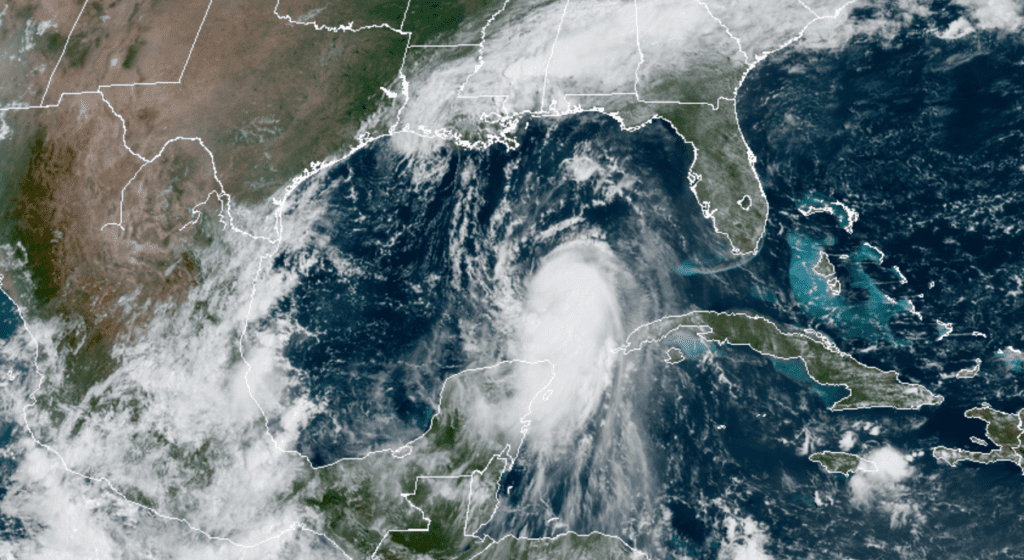
Satellite imagery from Tuesday morning showed Laura has become better organized after crossing over western Cuba and entering the southeastern Gulf of Mexico. The hurricane is currently on the south side of a large-deep layer ridge of high pressure situated over the southeastern United States. Laura will be steered to the west-northwest today but is expected to turn to the northwest tonight and to the north Wednesday and Thursday as the storm moves toward a break in the high pressure ridge situated over Texas and the southern Plains. This will result in the hurricane making landfall in the area of southwestern Louisiana or the upper Texas coast late Wednesday night or Thursday morning.
08/25/2020 10:30 AM CDT
The computer-forecast solutions have been struggling to pinpoint the exact location of that break in the high pressure ridge to help determine landfall. Several solutions show landfall along the upper Texas coast between Galveston and Port Arthur while other solutions show landfall in southwestern Louisiana. There are couple of ensemble solutions that show landfall could occur even further south along the Texas coast. The new 10 am NHC forecast was nudged a little further to the west of previous track forecasts. The forecast cone of uncertainty at landfall stretches from just west of Galveston, Texas to just east of Lake Charles. Louisiana. The center of the cone at landfall is the Texas/Louisiana border.
I want to urge everyone to stay abreast of the latest National Hurricane Center forecasts as the track could still shift a little further to the west.
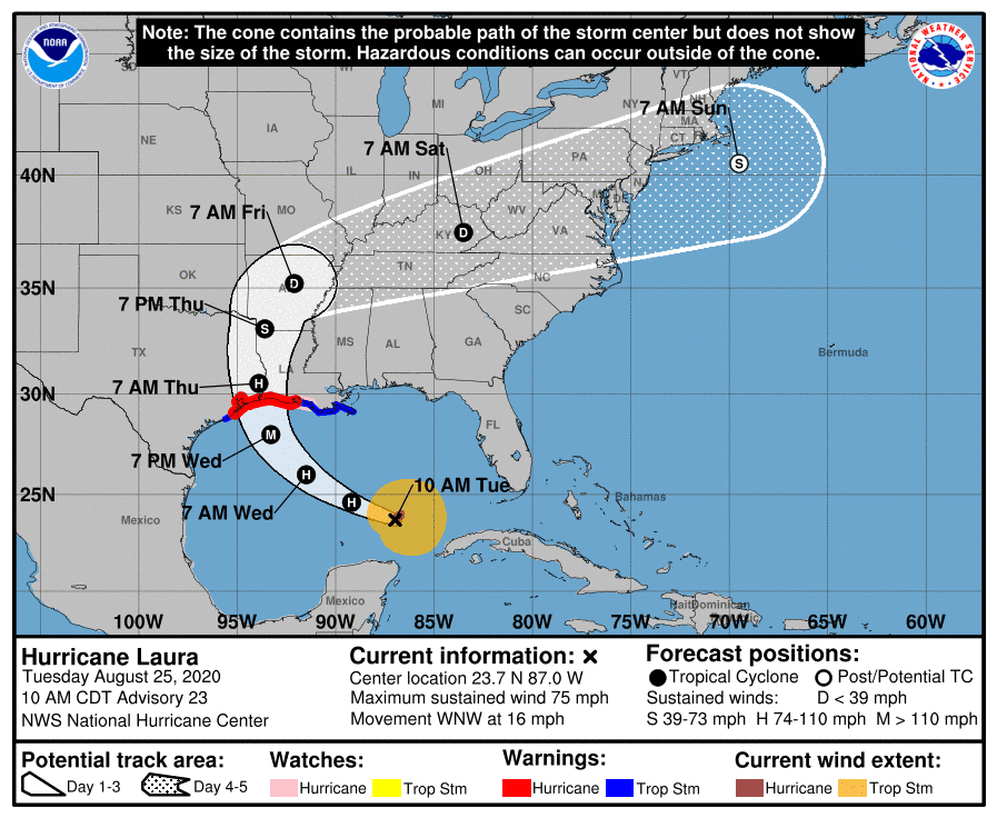
After landfall early Thursday morning, the center of Laura is expected to track north into East Texas or western Louisiana Thursday, then recurve eastward through the Tennessee Valley and the mid-Atlantic States Friday into Saturday.
Conditions appear favorable for Laura to strengthen over the next 36 hours, and the new intensity forecast calls for Laura to become a major hurricane during this time. The global models are in good agreement that the hurricane should encounter increasing shear in the last 12 hours before landfall, although the potential impacts on the landfall intensity are unclear at this time.
As of 10 am CDT, the center of Hurricane Laura was located in the southeastern Gulf of Mexico, about 620 miles southeast of Galveston. Laura was moving toward the west-northwest near 16 mph and this general motion should continue today. A turn toward the northwest is forecast by Wednesday, and a northwestward to north-northwestward motion should continue through Wednesday night. On the forecast track, the center of Laura will move across the southeastern Gulf of Mexico today. Laura is then forecast to move over the central and northwestern Gulf of Mexico tonight and Wednesday, approach the Upper Texas and Southwest Louisiana coasts on Wednesday night and move inland near those area on Thursday. Reports from NOAA and Air Force Reserve Hurricane Hunter aircraft indicate that maximum sustained winds are near 75 mph with higher gusts. Significant strengthening is forecast during the next 36 hours.
Based on the latest forecast track, hurricane Laura is not expected have a major impact on Hill Country or Central Texas weather. Outer rain bands from the storm are predicted to begin spreading inland along the middle Texas coast (Matagorda, Wharton and Colorado counties) Wednesday night and continue through Thursday evening. Rain amounts are forecast to generally average between 0.5 and 1 inch, with isolated heavier totals. Further inland, a few showers and thunderstorms are forecast to spread northwest toward the Austin/Interstate 35 corridor Thursday and Thursday evening, but rain amounts should only average around a quarter inch.
There will be a 20-30 percent chance for additional scattered showers and thunderstorms across Central Texas and the middle Texas coast Friday as moisture is drawn inland from the western Gulf.
Locations along the middle Texas coast can expect strong and gusty north and northwesterly winds to near 40 mph early Thursday as the center of Laura moves inland. Across Central Texas, expect wind speeds of 10-20 mph.
I’ll pass along another update this afternoon following the 4 pm National Hurricane Advisory.
Bob
Social Media