This has been quite the June heatwave, with temperatures since the start of the month averaging among the hottest ever observed for June. Unfortunately, no significant change to the hot and dry pattern is expected over the coming week as the summertime heat dome continues to heavily influence our weather.
Monday’s weather maps showed a broad ridge of high pressure in the middle and upper atmosphere stretching from northern Mexico to the middle Atlantic states. The ridge is causing a dry, stable and very hot weather pattern across all of Texas. Interestingly, the center of the ridge which had been over Texas this weekend, is now located over the middle Mississippi Valley. Forecasts call for the center of the ridge to remain east of Texas through the middle of the week, then shift west to the southern Plains late week and through the upcoming weekend.
High temperatures Monday afternoon through Thursday afternoon are forecast to be just slightly lower thanks to the center ridge being not directly over Texas. Wednesday is shaping up to have the least hot temperatures of the week, with readings then trending hotter late week and into the weekend.
- High temperatures Monday afternoon are predicted to be near 100-103 degrees across the Hill Country and Central Texas regions, and in the mid to upper 90s across the coastal plains.
- High temperatures Tuesday are forecast to be around 100 degrees across the Hill Country and Central Texas regions, and in the mid-90s across the coastal plains.
- High temperatures Wednesday are forecast to be near 98-100 degrees across the Hill Country and Central Texas regions, and in the mid-90s across the coastal plains.
- High temperatures Thursday and Friday are predicted to be near 100-103 degrees across the Hill Country and Central Texas regions, and in the upper 90s across the coastal plains.
Mostly sunny and very hot weather is expected for the upcoming weekend as the large ridge of high pressure sets up over the middle of the country, including Texas. Forecasts indicate parts of Central Texas could see a slight possibility for a few spotty rain showers Saturday when a weak cold front slides southwest into Central Texas out of the Mississippi Valley. The probability for rain at any given location will be less than 20 percent. With little moisture in place, rain amounts, if any, will be less than a tenth of an inch. Overall, expect few changes to the ongoing hot and dry pattern.
- High temperatures Saturday and Sunday are forecast to be near 101-103 degrees across the Hill Country and Central Texas regions, and into the upper 90s across the coastal plains.
Looking out into next week, the latest set of forecast solutions calls for few changes in the sunny, hot, and dry pattern. The large ridge of high pressure is predicted to remain over Texas and the middle of the country throughout the week, causing more of the same. Daily high temperatures are forecast to remain around 100-103 degrees, with upper 90s towards the coast. Longer-range solutions call for similar conditions to continue through the end of the month.
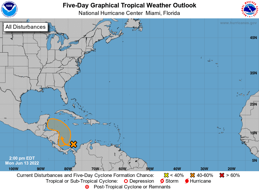
Tropical Weather Outlook
A broad area of disturbed weather is located over the southwestern Caribbean Sea, associated with a surface trough of low pressure. Some slow development is possible, and a tropical depression could form by late this week if the system remains over water. The disturbance is expected to move northwestward near the coasts of Nicaragua and Honduras during that time. Regardless of development, this system could produce periods of heavy rainfall across portions of eastern Nicaragua and eastern Honduras late this week.
NHC forecasters are giving this system a 10 percent chance for tropical development over the next 48 hours, and a 40 percent chance for tropical development over the next five days.
Rare Morning Sky Show
For the first time since Dec. 2004, five naked-eye planets have lined up at dawn in order of their distance from the sun. It’s a rare morning sky show. Next week, the Moon will hop from planet to planet, producing a series of early morning conjunctions. Set your alarm for about 45 minutes before sunrise and enjoy the show!

Have a good week.
Bob
Social Media