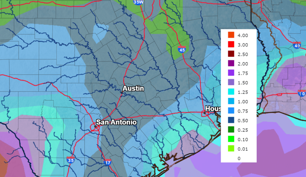
Following the heavy rains earlier this week, the weather pattern has become more stable across the Hill Country and Central Texas. That unusual August cold front which helped kick off the widespread showers and storms is still with us. After pushing off the coast Wednesday, the front has pulled back north. As of midday Friday, the front was situated close to Interstate 10, between San Antonio and Houston. While not quite the catalyst it was earlier in the week, the front is still expected to be the focus for the development of scattered showers and thunderstorms across the coastal plains region Friday afternoon and evening. The probability for rain will be near 50 percent, with rain amounts averaging around a quarter inch, and isolated totals to 1 inch. For the Hill Country and Central Texas regions, a fairly moist and slightly unstable atmosphere continues across the area. There will be a slight chance (a 20 percent chance) for a few scattered rain showers and thunderstorms this afternoon and evening. Spotty totals to around a quarter inch will be possible. Otherwise, this afternoon’s weather will be partly cloudy, warm, and humid with high temperatures generally in the mid to upper 90s. Low 90s are forecast towards the coast.
Few changes in the pattern are forecast Saturday through Monday as Texas remains between ridges of high pressure to our west and southeast. The cold front around I-10 is predicted to weaken and dissipate Friday night, so it should no longer be a major factor in the weather through the weekend. Some spotty rain showers and thunderstorms will still be possible across the Hill Country and Central Texas regions all three days, but the chance for rain will only be 20 percent. Scattered showers and isolated thunderstorms look to be more active across the coastal plains region, where the probability for rain will be 40 percent. High temperatures each day are forecast to be in the mid and upper 90s, with low 90s expected near the coast. The sky will be mostly sunny to partly cloudy.
Our weather is forecast to become more unsettled next Tuesday through Friday when a weak cold front sinks south and stalls across North Texas. At the same time, considerable moisture is predicted to be drawn north from the Gulf ahead of the front. This atmospheric set up will lead to an increased chance for scattered rain showers and thunderstorms across the entire region through the period. The probability for rain will be near 50 percent Tuesday and Wednesday and around 40 percent Thursday and Friday. The rain is forecast to be mainly be light to moderate in intensity. Rain totals Tuesday through Friday are forecast to generally be around 1-1.5 inches. Expect a partly to mostly cloudy sky Tuesday through Friday, with high temperatures in the low 90s.
NWS Rainfall Forecast for the Period 7 pm Friday through 7 pm next Friday
The early outlook for Labor Day weekend shows the possibility for more scattered rain showers and thunderstorms across the region as considerable moisture continues to spread north from the Gulf. It doesn’t look like a washout, but I do think we’ll see some periods of scattered rain. High temperatures are forecast to generally be in the low 90s.
Tropical Weather Update
The National Hurricane Center is currently keeping an eye on two systems, but neither one is showing signs of development in the near-term.
The first system is located over the eastern Caribbean Sea where a trough of low pressure is producing limited shower and thunderstorm activity. Environmental conditions could become more conducive for slow development of this system during the early or middle part of next week while it moves generally westward at 10 to 15 mph across the central and northwestern Caribbean Sea.
NHC forecasters are giving this system a zero chance for tropical development through the weekend, and a 20 percent chance for development over the next 5 days.
The second system is located over the eastern tropical Atlantic Ocean where a broad and complex area of low pressure is producing an area of disorganized showers and thunderstorms. The interaction of this feature with an approaching tropical wave could support some gradual development of the system during the early and middle parts of next week while it moves slowly westward to west-northwestward across the eastern and central tropical Atlantic.
NHC forecasters are giving this system a 10 percent chance for tropical development over the next 48 hours and a 30 percent chance for development over the next 5 days.
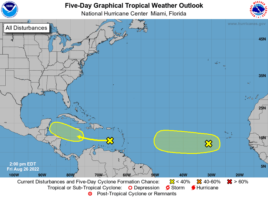
Elsewhere, conditions are quiet and tropical cyclone development is not forecast over the next 5 days.
Have a good weekend!
Bob
Social Media