…A Hurricane Warning has been posted from San Luis Pass Texas to Intracoastal City Louisiana…
…A Tropical Storm Warning has been posted from Sargent Texas to San Luis Pass…
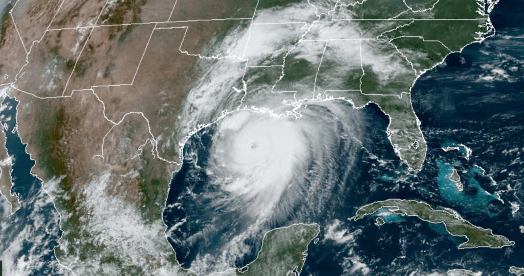
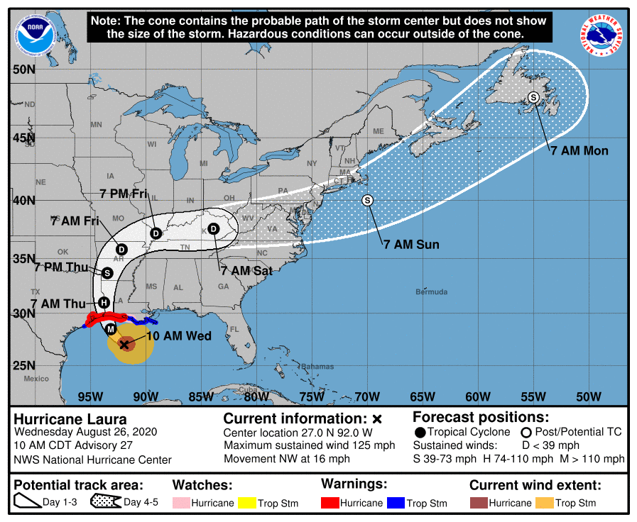
This morning, Laura has become a large and very powerful category 3 hurricane with sustained winds of 125 mph. The hurricane is expected to cause a catastrophic storm surge, extreme winds and flash flooding for areas near and east of where it makes landfall. Overnight, Laura began to make the much anticipated turn to the northwest, following the weakness located between two high pressure ridges. Because of this turn, confidence has increased in Laura’s forecast track and area of landfall. A gradual turn toward the north-northwest and north is expected this afternoon and evening which should bring the center of Laura onshore in southwestern Louisiana or extreme eastern Texas somewhere around midnight tonight. The cone of uncertainty at landfall has narrowed to the area from just east of the Bolivar Peninsula to near Cameron, Louisiana.
NOAA-RAMMB 08/26/2020 11:20 AM CDT
As of 10 am CDT, the eye of Hurricane Laura was located about 235 miles southeast of Galveston, Texas. Laura was moving toward the northwest near 16 mph. Data from NOAA and Air Force Hurricane Hunter aircraft indicate that maximum sustained winds have increased to near 125 mph with higher gusts. Laura is now a category 3 hurricane on the Saffir-Simpson Hurricane Wind Scale. Laura is likely to continue strengthening today while it moves over the warm waters of the northwestern Gulf of Mexico and low vertical wind shear. Laura is expected to be an extremely powerful category 4 hurricane, with winds greater than 129 mph, when it reaches the northwestern Gulf coast tonight.
Laura has become a large hurricane, with hurricane-force winds extending outward up to 70 miles from the center and tropical-storm-force winds extend outward up to 175 miles.
Rapid weakening is expected after Laura makes landfall tonight. However, Laura will likely cause a swath of damaging winds well inland over western Louisiana and eastern Texas tonight and Tuesday.
The updated National Hurricane Center forecast track calls for Laura to make landfall in southwestern Louisiana or extreme East Texas tonight around midnight and move north along the Sabine River Thursday, reaching the Shreveport area late Thursday afternoon, moving into southwestern Arkansas Thursday evening.
With Laura forecast to pass well east of Central Texas and the middle Texas coast, no direct impacts are expected. An area of tropical moisture on the outer fringes of Laura spread west in parts of Fayette and Bastrop Counties this morning, producing totals of between 0.25 and 1.20 inches. Additional scattered rain showers and thunderstorms are forecast for areas along and east of Interstate 35 this afternoon as the moisture remains around the area. The probability for rain will be near 30 percent. Totals will generally average around a quarter inch, with isolated totals in excess of an inch.
Tonight through Thursday afternoon, there will be a 30-40 percent chance for scattered rain showers and thunderstorms for areas along and east of Interstate 35 as some of the outer rain bands from Laura spread west. Rain totals should average between 0.25 and 0.5 inches, with isolated totals in excess of an inch.
The chance for rain is forecast to fall to 20 percent Thursday night and Friday across Central Texas but will remain near 40 percent across the coastal plains.
Bob
Social Media