Hurricane Laura made landfall early Thursday morning, around 1 am CDT, near Cameron, Louisiana. Maximum sustained winds at landfall were 150 mph, which is near the high end of category 4 hurricane status. At the time of landfall, Laura was a ferocious looking hurricane with a clear circular eye, an intense eyewall and tightly-coiled spiral rain bands.
Some interesting statistics about Laura:
- Calcasieu Pass in Cameron, Louisiana, which was in the eye of Laura, measured the highest known storm surge at 8.9 feet. A higher storm surge may have occurred at the tide gauge at Freshwater Canal Locks, on the south-central coast of Louisiana, but the instrument had stopped transmitting data before the peak surge arrived. The Calcasieu River at Saltwater Barrier (near downtown Lake Charles) produced only minor flooding as it crested at 4.86 feet, well below the predicted record crest of 15-plus feet. Since Laura’s center passed directly over Cameron and very close to Lake Charles, it appears the wind trajectory was not optimal for pushing large amounts of surge upriver toward the city. The surge could have been much higher at both locations had Laura made landfall slightly further to the west, closer to the Texas/Louisiana border.
- With Laura having 150 mph winds at landfall, it ties for the fifth-strongest hurricane on record to ever make landfall along the continental U.S.
- Laura is the seventh named storm to make landfall in the U.S. so far in 2020. This sets a record for the earliest a seventh storm has made a U.S. landfall. Only two other hurricane seasons have had six U.S. landfalls by the end of August – 1886 and 1916.
- Laura rapidly intensified by a remarkable 65 mph in just 24 hours on August 26. This ties Hurricane Karl of 2010 for the fastest intensification rate in the Gulf of Mexico on record.
Laura tracked to north across western Louisiana Thursday, reaching southern Arkansas by late Thursday afternoon. The satellite and radar presentation of the tropical cyclone shows Laura has been weakening and degrading. At 4 pm, the center of Tropical Storm Laura was located about 80 miles northeast of Shreveport, Louisiana. Laura was moving toward the north-northeast near 15 mph, and this motion should continue through Thursday night. A northeastward to east-northeastward motion is expected to begin on Friday and continue into Saturday. On the forecast track, the center of Laura is forecast to move over Arkansas Thursday night, the mid-Mississippi Valley on Friday, the mid-Atlantic states on Saturday and over the western Atlantic on Sunday. Continued weakening is forecast, and Laura is expected to weaken to a tropical depression Thursday night.
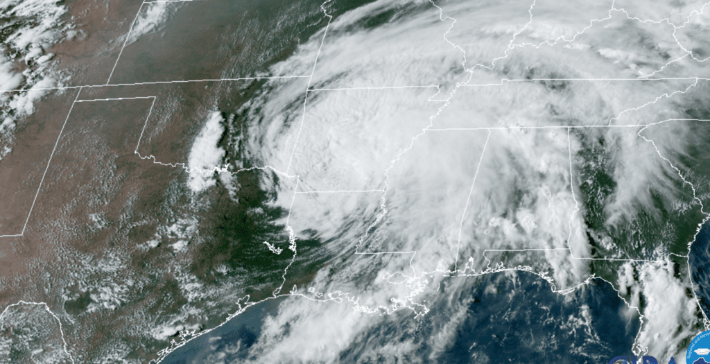
NOAA/RAMMB 08/27/2020 4:30 pm CDT
With the hurricane going well to the east of Central and South Texas, our region dodged a big bullet. The greatest impact across our area was the 1-inch totals of rain across parts of Bastrop County on Wednesday. The highest wind gusts observed were 35 mph at Palacios, 25 mph at Bay City, 24 mph at Wharton, 27 mph at Eagle Lake and 20 mph at Austin-Bergstrom International Airport.
A sunny, dry and very hot pattern is forecast Friday and this weekend as a heat wave cranks up again across our region. High temperatures near 100-104 degrees are forecast across the Hill Country and Central Texas regions while upper 90s are expected across the coastal plains region.
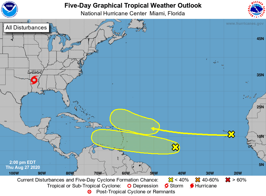
National Hurricane Center forecasters are monitoring a strong tropical located over the far eastern tropical Atlantic, close to the Cabo Verde Islands. This wave is producing disorganized shower activity as it moves to the west. Although environmental conditions are not expected to be conducive for development during the next couple of days, they are forecast to gradually become more favorable over the weekend and into early next week when the wave moves into the central and then western tropical Atlantic. The National Hurricane Center is predicting the wave to be somewhere east of the Lesser Antilles in about 5 days. NHC forecasters are giving this system a 20 percent chance for development over the next 5 days.
Forecasters are also watching the central Topical Atlantic where shower and thunderstorm activity associated with a tropical wave have increased. Gradual development of this system will be possible over the next several days as the wave moves westward at 15 to 20 mph. NHC forecasters give this system a 30 percent chance for development over the next 5 days.
The peak of the Atlantic hurricane season is roughly September 10th, so we still have a long hurricane season ahead of us. Just because Texas has been impacted by Hanna and Laura this year doesn’t mean we aren’t vulnerable to additional storms.
Stay tuned and stay cool!
Bob
Social Media