After several sunny days, we’re closing out the workweek with widespread clouds and even a few spotty light rain showers. Friday’s weather maps showed a couple of weak disturbances tracking northeast across Texas ahead of a larger low pressure located near the Four Corners region. These disturbances will cause the sky to remain cloudy this afternoon through tonight. There will be a slight chance for some additional spotty light rain showers across the Intestate 35 corridor, Central Texas and coastal region this afternoon and evening. The probability for rain will be near 20-30 percent. However, due to very dry air in the lower atmosphere, rain amounts, if any, will only amount to a few hundredths of an inch. Afternoon temperatures are forecast to only warm to the mid and upper 50s.
There will be a chance for rain showers across the region Saturday as the trough of low pressure over the Four Corners tracks east to the southern Plains states, forcing a Pacific cold front across Texas. The probability for rain will only be around 20 percent across the Hill Country, with totals averaging just a couple hundredths of an inch. Across Central Texas, the probability for rain will range from 30 percent along the I-35 corridor, to 50 percent near La Grange and Brenham. Rain amounts should average less than a tenth of an inch. The best chance for rain and even some isolated thunderstorms will occur across the coastal plains region, where the probability for rain will be near 70 percent. Here, rain amounts should average between a tenth and a quarter inch.
Clouds are forecast to slowly clear from west to east Saturday morning through Saturday evening as the Pacific cold front brings in drier and slightly cooler air. Sunny weather will be in place Sunday and Monday.
- Saturday’s high temperature will range from the mid-60s across the western Hill Country, to the upper 50s across Central Texas ad the coastal region.
- Lows Sunday morning will include the mid-30s across the Hill Country, the upper 30s across Central Texas, with low to mid-40s across the coastal plains.
- High temperatures Sunday are forecast to be in the low 60s.
- Lows Monday morning will generally be around 38-40 degrees.
- High temperatures Monday will be in the upper 60s.
The highlight of next week’s weather will be the arrival of our next rain-producing system on Tuesday. Forecasts call for another trough of low pressure to dig south to the Four Corners region Monday, but this system is predicted to take a more southerly path east across West and Northwest Texas Tuesday. With the trough moving closer to our region, it is expected to pull quite a bit of moisture north from the Gulf of Mexico. In addition, we should see more atmospheric lift and instability. Forecasts call for widespread rain showers to develop after midnight Monday night. Widespread showers and isolated thunderstorms are forecast across the region Tuesday. Do note there’s a small chance some of Tuesday’s thunderstorms could be strong to severe. The activity should taper off from west to east late Tuesday afternoon into Tuesday evening when a cold front brings in drier and cooler air.
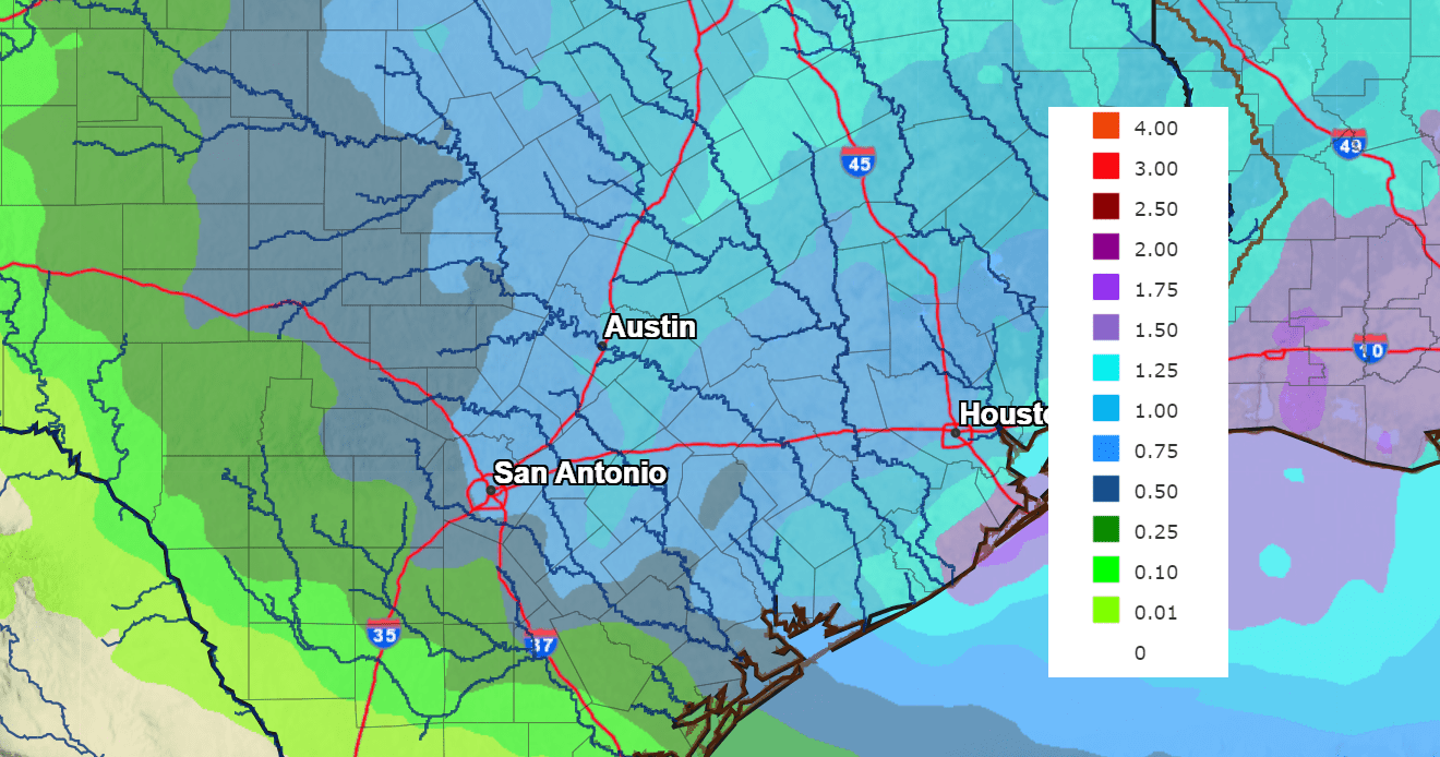
This is shaping up to be a good rain for our area. Rainfall forecasts call for widespread totals of 0.75 to 1.25 inches across the eastern Country, Central Texas and the middle Texas coast. Totals across the western and central Hill Country are forecast to average between 0.25 and 0.75 inches.
NWS Rainfall Forecast for the Period 6 pm Monday through 6 pm Tuesday:
I do want to point out that some forecast model solutions are calling for the development of a rain/snow mix across parts of the Concho Valley, Northwest, and North Texas Tuesday morning. But these same solutions are calling for just rain across the eastern Hill Country, Central Texas, and the coastal plains. Stay tuned for further updates.
Mostly sunny, dry, and cool weather is forecast next Wednesday through Saturday. Expect high temperatures in the 50s to low 60s, with lows in the 30s to the low 40s. A light freeze is expected across the Hill Country and parts of the Interstate 35 corridor next Wednesday and Thursday mornings.
Long-range forecasts point toward another chance for rain developing sometime next Sunday or Monday when a trough of low pressure is forecast to move over our area. Rain amounts are not expected to be very heavy. Near-normal temperatures are forecast toward the end of the month.
Venus and Saturn Conjunction Sunday Evening
Sunday evening, January 22, catch the dazzling planet Venus and much fainter planet Saturn near each other after sunset. Start looking near where the sun just set as twilight falls. As a bonus, you may spot the young waxing crescent moon closer to the horizon. The sliver of a crescent moon will set about 30 minutes before the planets. Then, the planets will disappear over the horizon roughly 90 minutes after sunset.
At their closest, Venus will pass 0.4 degrees (almost the width of a full moon) from Saturn on the sky’s dome. You should have no problem spotting Saturn near Venus with the eye alone. Both are bright planets! But Venus is much, much brighter. Saturn is shining at +0.7 magnitude. Meanwhile, Venus shines at -3.9 magnitude. In fact, Venus ranks as the 3rd-brightest celestial body in the sky, after the sun and moon. Venus is so dazzlingly bright that some sharp-sighted people can even see spot it in daylight. (earthsky.org)
Have a good weekend.
Bob
Social Media