The August doldrums are definitely upon us. A stagnant ridge of high pressure in the middle and upper atmosphere continues to produce a very persistent pattern of sizzling hot and dry weather. Unfortunately, this pattern is showing no signs of breaking down anytime soon, so get ready for more of the same. In the longer-term outlook, the high pressure ridge is predicted to shift more to the west next week and this should have a moderating effect on the streak of triple-digit temperatures. While a few showers may enter the forecast next week, no widespread rain is expected anytime soon.
Monday’s weather maps showed a broad, stable ridge of high pressure covering Texas and the southern U.S. The ridge was centered over southern Louisiana, with another center located across northern Mexico, to the south of El Paso. Forecasts call for the ridge of high pressure to remain over our region throughout the week and the upcoming weekend as the ridge center near El Paso becomes the dominant feature. For the Hill Country and Central Texas regions, this means more of the same. Sunny, hot and dry weather will be in place all week and through the weekend. High temperatures look to be very consistent near 100-103 degrees.
Fortunately, a moderate pressure gradient is causing breezy south winds across much of the state. South winds at 10-15 are forecast to continue through late.
Across the coastal plains region, there will be a 20-30 percent chance for spotty rain showers and isolated thunderstorms each day through Sunday as the Sea Breeze fights off the ridge and pushes north from the coast. The spotty shows are forecast to extend as far inland to just north of Interstate 10. For locations that happen to see rain, amounts are forecast to average between a quarter and a half inch. Overall, weather conditions will be partly cloudy and hot with daily high temperatures in the middle 90s.
The outlook for next week calls for a few minor changes in the hot and dry pattern. Forecasts call for the center of the high pressure ridge to migrate to or just west of the Four Corners region. The ridge over Texas is predicted to weaken slightly and this will allow Gulf moisture to spread from the coast north into Central Texas and the Hill Country. A few spotty afternoon showers will be possible across the region throughout the week. Rain amounts, if any, should average less than a quarter inch. In addition, high temperatures next week are predicted to lower a couple of degrees to near 98-100 degrees.
Across the coastal plains region, there will be a 30-40 percent chance for scattered rain showers and isolated thunderstorms each day as moisture levels slowly increase. Spotty totals of 0.25-0.50 inches are forecast. High temperatures next week will be in the low and mid-90s.
Long-range forecasts into the last week of the month call for a very similar pattern as Texas remains under the influence of a somewhat weaker ridge of high pressure.
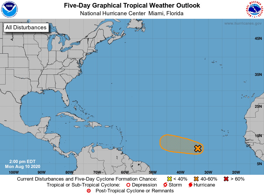
Tropical Weather Outlook
Weather conditions are currently quiet across the Gulf of Mexico and the Caribbean Sea.
However, National Hurricane Center (NHC) forecasters are monitoring a strong tropical wave located in the eastern tropical Atlantic, about 700 miles west-southwest of the Cabo Verde Islands. The area of shower and thunderstorm activity associated with the wave have changed little in organization since yesterday. Environmental conditions are expected to be somewhat conducive for development, and a tropical depression could form during the next day or two while the disturbance moves generally westward to west-northwestward at 10 to 15 mph across the tropical Atlantic. Conditions are forecast to become less conducive for development by the end of the week. NHC forecasters are giving this system a 60 percent chance for development over the next 5 days.
Perseid Meteor Shower
The annual Perseid meteor shower is underway. Debris from giant comet 109P/Swift-Tuttle is disintegrating in Earth’s atmosphere, producing a nightly spray of shooting stars expected to peak on Aug. 11th and 12th. But do note the Moon (in Taurus) rises around midnight, and its light will interfere an extent during the prime meteor hours from midnight to dawn. So you might do best before then, from about 11 p.m. through moonrise when the sky will be its darkest.
Bob
Social Media