…Confidence has increased Marco will make landfall in southeastern Louisiana. The forecast track for Laura has shifted further west towards Southeast Texas and will need to be watched…
Following the major shift in the forecast track away from Texas Saturday afternoon, successive model solutions overnight and this morning have continued a similar trend. As a result, confidence is now fairly high Marco will make landfall over southeastern Louisiana Monday evening. Our attention really needs to focus on Tropical Storm Laura, which could make landfall along the upper Texas coast.
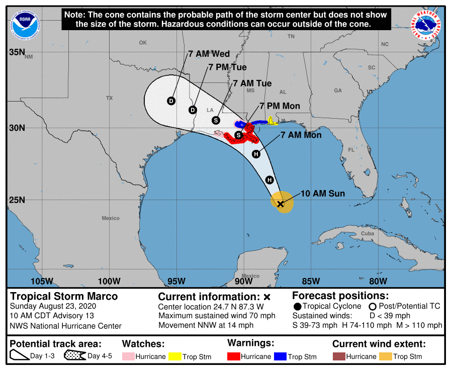
First, here is the latest on Tropical Storm Marco. As of 10 am CDT, the center of Tropical Storm Marco was located was located over the central Gulf of Mexico, about 325 miles south-southeast of the Mouth of the Mississippi River. Marco was moving toward the north-northwest near 14 mph, and this motion is expected to continue through tonight, followed by a turn to the northwest by Monday. On the updated forecast track, Marco will cross the central Gulf of Mexico today and will approach southeastern Louisiana on Monday. A gradual turn toward the west-northwest with a decrease in forward speed is expected after Marco moves inland.
Maximum sustained winds are near 70 mph with higher gusts. Some strengthening is anticipated and Marco is forecast to become a hurricane later today and be at hurricane strength when it approaches the northern Gulf Coast on Monday. Rapid weakening is expected after Marco moves inland.
After making landfall, the remnants of Marco are forecast to be steered slowly to the northwest. The 10 am forecast track calls for the remnants of Marco to spread into East Texas Tuesday evening, reaching Northeast Texas Wednesday. Based on this forecast track, the remnants of Marco are not expected to have any significant impact on Hill Country, Central Texas or middle Texas coast weather.
Tropical Storm Laura
There have been some concerning trends in the overnight and morning model guidance for the Texas and Louisiana coasts regarding the forecast track for tropical storm Laura. Laura is tracking along the southern side of a strong mid to upper level ridge over the southwest Atlantic Ocean and this ridge is forecast to build westward into the Gulf of Mexico over the next few days. This will keep Laura on a general west-northwest track heading across much of Cuba later today, tonight and into Monday. Laura is forecast to reach the southeastern Gulf of Mexico late Monday. Once over the Gulf of Mexico, the high pressure ridge is expected to continue steering the system toward the west-northwest, with a gradual turn toward the northwest once Laura reaches the western end of the ridge. Interestingly, overnight forecast solutions trended toward stronger ridging over the eastern Gulf, and this has resulted in a westward shift in the forecast track. As a result, this morning’s NHC forecast track has shifted west, with landfall now expected to be somewhere near the Texas/Louisiana border late Wednesday night/early Thursday morning. I will point out several of the global model solutions are showing landfall as a hurricane even further to the west—along the middle or upper Texas coast early Thursday morning.
Due to this uncertainty , the 10 am NHC forecast track now shows the cone of uncertainty extending west to Matagorda Bay. Over the next couple of days, we will need to monitor the strength of eastern Gulf of Mexico ridge as this could possibly move the point of landfall further down the Texas coast.
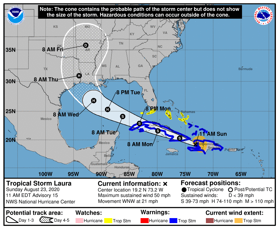
Based on the current track showing Laura making landfall somewhere near the Texas/Louisiana border, Laura will likely not have any significant impact on Central Texas weather. However, if the track does shift further to the west, outer rain bands could affect parts of our region, with heavier rains and stronger winds possible across the middle Texas coast. Stay tuned for updates over the next couple of days.
Latest Stats: As 10 am CDT, the center of Tropical Storm Laura was located about 95 miles southeast of the eastern tip of Cuba. Laura was moving toward the west-northwest near 21 mph, and this general motion with some decrease in forward speed is expected over the next couple of days. A turn toward the northwest is forecast on Wednesday. On the forecast track, the center of Laura will move near or over Cuba tonight and Monday, and move over the southeastern Gulf of Mexico Monday night and Tuesday. Laura is expected to move over the central and northwestern Gulf of Mexico Tuesday night and Wednesday.
Recent data from a NOAA reconnaissance aircraft indicate that maximum sustained winds are near 50 mph with higher gusts. The strongest winds are primarily occurring over waters to the northeast of the center. Little change in strength is forecast while Laura moves near Cuba. Strengthening is forecast after the storm moves over the Gulf of Mexico, and Laura is forecast to become a hurricane late Tuesday or Tuesday night.
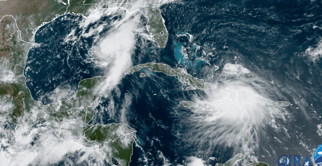
RAMMB-CIRA 08/23/2020 10:20 am CDT
Bob
Social Media