After a weekend of mild spring-like temperatures, chilly air has returned for a brief visit. A Canadian cold front sank south across the region late Sunday, allowing noticeable cooler air to spread to the south. As of midday Monday, temperatures were generally in the 40s to low 50s. Meanwhile, a large trough of low pressure is located over eastern New Mexico. Circulation around the trough is causing the development of widespread overrunning clouds, scattered rain showers and even a couple of isolated thunderstorms. According to LCRA’s Hydromet, rain amounts through midday have generally totaled less than a quarter inch, although there have been a couple of isolated totals up to a third of an inch.
Scattered rain showers and a few isolated thunderstorms are forecast to continue across the entire region this afternoon and tonight as the upper trough slowly tracks east through the Panhandle and Oklahoma. The rain will be light to moderate in intensity. The chance for rain is predicted to end from west to east late Monday night and toward daybreak Tuesday. Additional totals of a quarter inch are forecast across the Hill Country and Central Texas regions and up to a half inch across the coastal plains region. The threat for severe storms has diminished, although a couple of the this afternoon’s thunderstorms could produce some very small hail. Expect breezy northerly winds at 10-20 mph, with occasional gusts to 30 mph this afternoon and tonight.
High temperatures this afternoon are forecast to be in the upper 40s across the Hill Country, be around 50-52 degrees across Central Texas and in the mid to upper 50s across the coastal plains. Lows Tuesday morning will include the mid and upper 30s Hill Country, the low 40s across Central Texas and the mid to upper 40s coastal plains.
Clouds are predicated to clear early Tuesday morning, with the sky becoming mostly sunny. Temperatures will be a little warmer, with highs around 60-62 degrees. Breezy conditions will continue. Expect northerly winds at 10-15 mph through late afternoon. Clear and chilly weather is forecast Tuesday night. Lows Wednesday morning will include the low and mid-30s Hill Country, the mid and upper 30s Central Texas and the low 40s near the coast.
Sunny and warmer weather is expected Wednesday and Thursday when a weak ridge of high pressure sets up across Texas and the southern Plains. High temperatures are predicted to be near 70 degrees Wednesday and in the low to mid-70s Thursday. Lows Thursday morning will be in the low 40s while lows Friday morning will be near 48-50 degrees.
A trough of low pressure pushing east out of the Desert Southwest late week if predicted to push a cold front across Texas Friday afternoon into Friday evening. There may be just enough moisture in place to cause a few spotty light rain showers along the cold front. Rain amounts, if any, should total less than a tenth of an inch. Friday’s high temperature will be around 72-75 degrees.
Mostly sunny, dry and mild weather looks to follow the cold front this coming weekend. Expect high temperatures in the 60s, with low temperatures in the 40s.
The outlook for next week calls for mostly sunny, dry and quiet weather across the region as a weak ridge of high pressure sets up across Texas. High temperatures look to start the week in the low 70s, reaching the upper 70s to 80 degrees Wednesday through Friday. Low temperatures next week are predicted to be in the 50s to low 60s. The next chance for rain is predicted to occur sometime around or just after the middle of the month.
February Climate
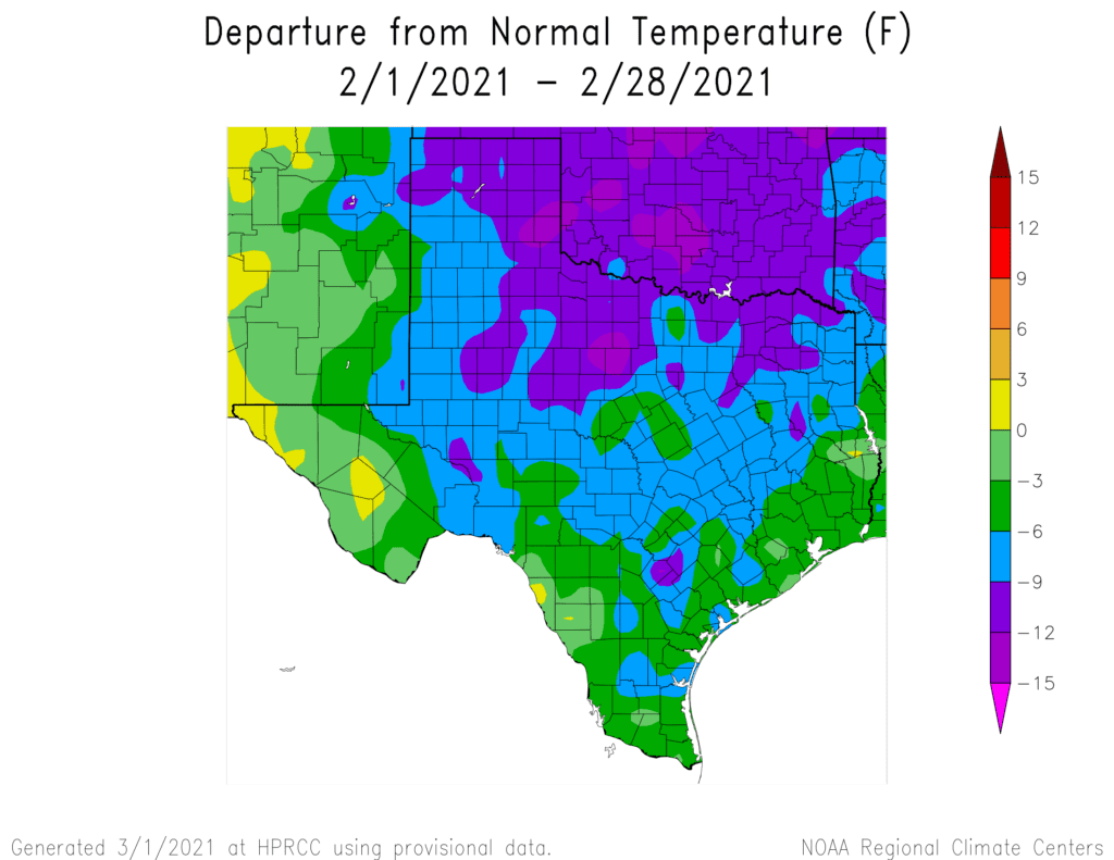
Temperatures for the month averaged well below normal due to the prolonged arctic outbreak in the middle of the month. Readings averaged between 5 and 10 degrees below normal across the Hill Country and much of Central Texas, and between 3 and 6 degrees below normal across the coastal plains region.
Rainfall averaged slightly below normal at most locations from the Hill Country to the middle Texas coast.
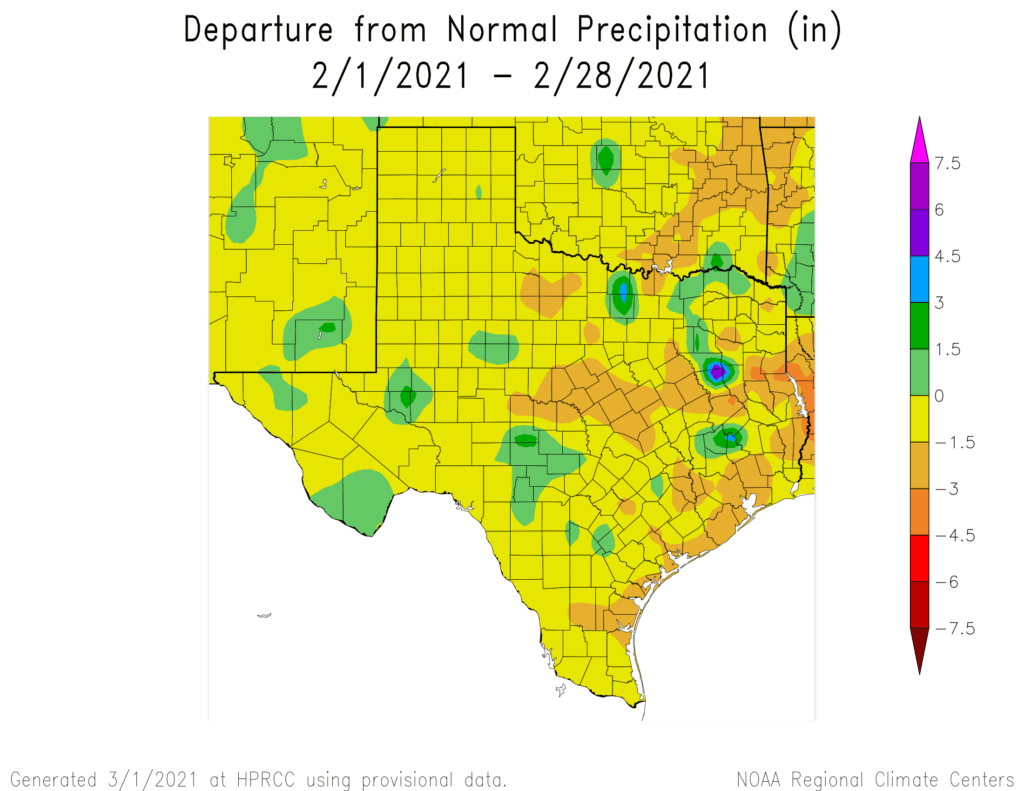
In Austin, Camp Mabry recorded a February average temperature of 48.3 degrees, which was 6.7 degrees below normal. February 2021 ranks as the 8th coolest February on record. February rainfall totaled 1.91 inches, which was 0.11 inches below normal.
Bob
Social Media