Quiet weather continues across the region as we start off the new week. The stable ridge of high pressure in the upper atmosphere which spread across Texas this weekend is now slowly departing to the east. However, the ridge is still expected to keep the atmosphere dry and stable through Tuesday. Expect a sunny sky this afternoon. Widespread low clouds are forecast to develop by midnight Monday night as a thin layer of moisture spreads north from the Gulf. A cloudy to mostly cloudy sky is forecast Tuesday. High temperatures both days are forecast to be in the low and mid-80s. Lows Tuesday morning will be mostly in the low 60s.
At the surface, strong and gusty southerly winds continue as our region is sandwiched between an area of high pressure over the eastern Gulf and an area of low pressure over the Texas Panhandle region. A strong pressure gradient between the two features is forecast to continue this afternoon through Tuesday. As a result, forecasts call for southerly winds with speeds of 10-20 mph and gusts to 30/35 mph this afternoon through Tuesday evening. These strong winds, in combination with extremely dry fuels and low relative humidity levels, will cause a critical risk for wildfire spread today through Tuesday. A Red Flag Warning has been posted for most of the Hill Country and Central Texas through 8 pm. (See fire weather section below).
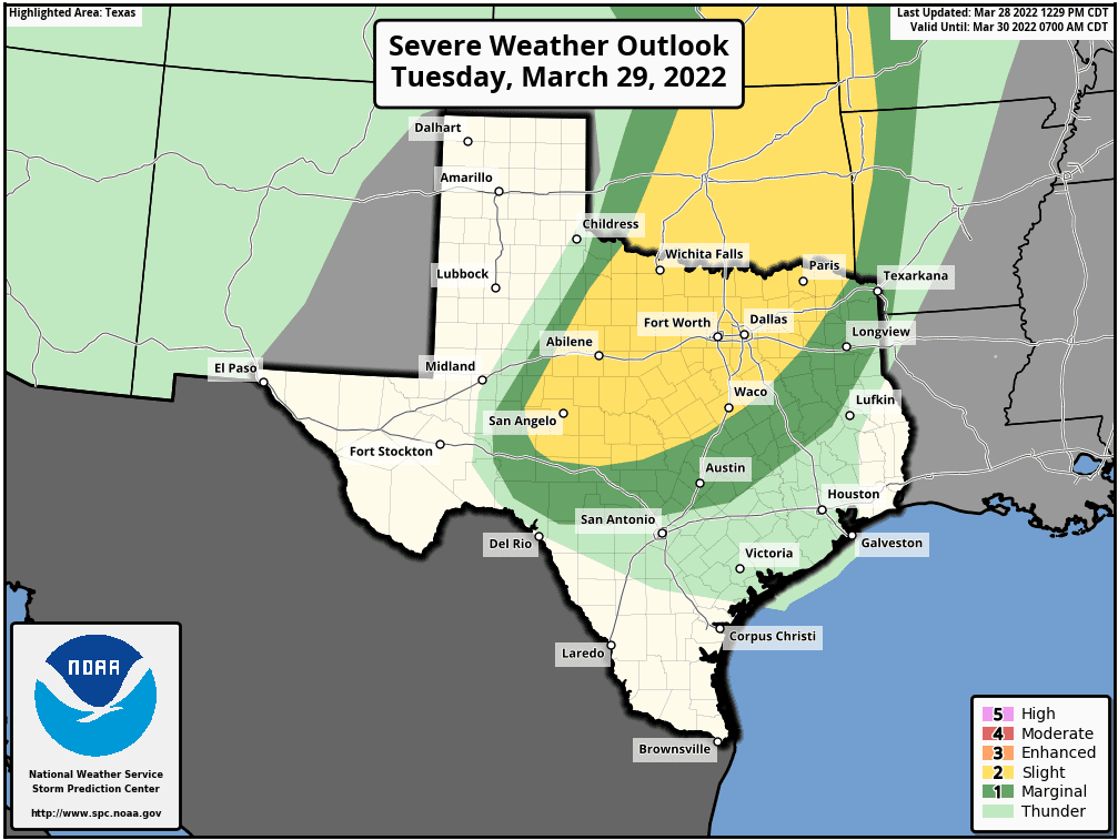
There will be a threat for strong to severe thunderstorms late Tuesday night into Wednesday morning for the much of the Hill Country and Central Texas. Forecasters continue to monitor a trough of low pressure in the middle atmosphere located off the California Coast. This system is forecast to push east over the next couple of days, dragging a Pacific cold front across our region Tuesday night into Wednesday morning. Forecasts call for an area of strong to severe thunderstorms to develop along and just behind the front –generally across Northwest Texas and the Concho Valley regions late Tuesday evening and toward midnight. The line of storms is forecast to push to the east and spread across the Hill Country between roughly 2 and 4 am, reaching the Austin/Interstate 35 corridor between about 4 am and 6 am. The storms are forecast to continue pushing east across Central Texas and the coastal plains regions after sunrise Wednesday morning. All of the rain and storms are forecast to push off the coast by early afternoon.
The atmospheric setup in advance of the trough and cold front is forecast to be favorable for the development of severe thunderstorms. However, the true setup and the time of day make this setup a bit different from that which we saw a week ago with that produced the numerous tornadoes. For this event, the primary severe weather threats are forecast to be damaging straight-line winds and large hail. However, an isolated tornado cannot be totally ruled out. The Storm Prediction Center is calling for the greatest threat for severe storms to occur across North Texas, extending southwest to around San Angelo. SPC has placed the area north of a line stretching from Sonora, to Mason, to Waco under a Slight Risk (a 2 out of 5 risk) for severe thunderstorms through sunrise Wednesday. The area north of a line stretching from around Del Rio, to just north of San Antonio, to near College Station (including metro Austin) has been placed under a Marginal Risk (a 1 out of 5 risk) for severe thunderstorms through sunrise Wednesday. Areas southeast of the Marginal Risk area are forecast to have scattered thunderstorms—some possibly strong.
Rain amounts from the rain and storms Tuesday night into Wednesday morning are not predicted to be very heavy, with most totals in the range of 0.25 to 0.5 inches.
Sunny, windy and mild weather is expected Wednesday afternoon in the wake of the cold front. Expect strong northwesterly winds of 20-30 mph, with gusts to 40 mph. The combination of very dry air and strong winds is expected to cause elevated fire weather conditions Wednesday afternoon. High temperatures Wednesday are forecast to be in the low and mid-80s.
Winds will drop off Wednesday evening and Wednesday night as a dome of high pressure spreads over the area behind the cold front. A weak Canadian cold front is predicted to push south through the area Wednesday night, bringing slightly cooler temperatures for Wednesday night and Thursday. Lows Thursday morning will include the low 40s across the Hill Country, the mid and upper 40s across Central Texas and be around 50 degrees across the coastal plains. High temperatures Thursday are forecast to be in the mid and upper 70s.
A sunny to mostly sunny sky is forecast Thursday through Friday. Fairly light winds Thursday will give way to breezy south winds of 10-20 mph Friday. Lows Friday morning will be in the low 50s. Highs Friday afternoon will be in the low 80s.
There will be a 20 percent chance for a few spotty light rain showers late Friday night into early Saturday morning as moisture increases ahead of another weak cold front. Rain amounts, if any, should total just a few hundredths of an inch.
Mostly sunny weather is forecast Saturday through Sunday. High temperatures will be in the low 80s, with lows in the mid and upper 50s.
The outlook for next week is calling for a slightly unsettled weather pattern Monday through Wednesday as a weak trough of low pressure slowly tracks to the east out of northern Mexico and the southwestern U.S. Increasing moisture ahead of the trough is forecast to cause a slight chance for rain showers and isolated thunderstorms Monday afternoon through Wednesday morning. Rain amounts look to be somewhere in the range of 0.25 to 0.50 inches. Sunny and dry weather will follow next Thursday and Friday. High temperatures next week are forecast to generally be in the low and mid-80s, with lows in the 50s.
Fire Weather
The combination of dry air and moderate winds will cause critical fire weather conditions this afternoon and evening. The National Weather Service has posted a Red Flag Warning for the much of the Hill Country and Central Texas through 8 pm Monday evening. Any outdoor activity that could lead to the development of sparks and resulting wildfire potential is highly discouraged!
On Tuesday, increased relative humidity levels are expected, but wind speeds will remain strong, leading to a high fire danger—mainly for areas along and west of Interstate 35.
On Wednesday, near critical to critical fire weather conditions will return to the region behind the cold front. Minimum relative humidity readings in the teens west to 20s east and westerly winds of 15 to 25 mph with gusts to 40 mph are expected. The Texas Forest Service is calling for very high to extreme fire danger for most of South Central Texas.
Fire weather conditions are forecast to temporarily improve some Thursday as light winds develop across the region.
Fire weather conditions are forecast to deteriorate across the region Friday as southerly winds increase to 10-20 mph.
Have a good week!
Bob
Social Media