First up today is a developing trough of low pressure over the north central Gulf of Mexico. National Hurricane Center forecasters are monitoring an elongated trough of surface low pressure located over the north-central Gulf of Mexico, just offshore of southeastern Louisiana. Satellite images and coastal radars are showing scattered to numerous showers and thunderstorms over the area. Interestingly, this trough can be traced back to the boundary which pushed south across Texas and Louisiana on Wednesday. The trough is currently drifting slowly to the west-southwest and computer-forecast solutions call for the system to push inland along the lower Texas coast sometime between late Saturday and Sunday afternoon.
According to the Hurricane Center, tropical development, if any, will be slow to occur over the next couple of days as the trough’s mid-level circulation takes its time working down to the surface. NHC forecasters are giving this system a low chance, just a 10 percent chance, for tropical development over the next 48 hours and the next 5 days.
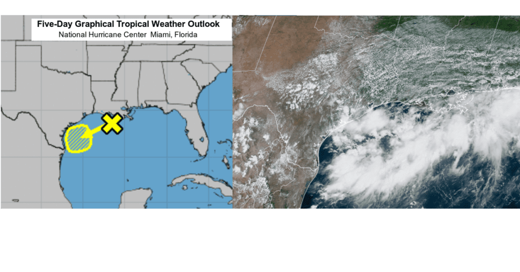
The trough is forecast to move west-southwest over the western Gulf of Mexico today and Saturday, with the majority of the shower and thunderstorm activity focused near and offshore the Texas coast. However, the system is also forecast to push an area of enhanced tropical moisture inland to roughly to the Interstate 10 corridor over the weekend. This will result in a good chance for showers and thunderstorms across the coastal plains over the weekend. The probability for rain is forecast to be around 60 percent both days. Total rain amounts through late Sunday are forecast to be in the range of 1-1.5 inches.
Tides are already elevated along the coast due to the full moon. Easterly and southeasterly low level winds on the north side of the surface trough may bump seas up a bit over the weekend and push tides a little higher. The water is expected to be way up the beaches at high tides over the weekend.
Unfortunately, this system is forecast to bring little, if any rain to Central Texas and the Texas Hill Country.
Weather Outlook
Our region remains in a pattern that is somewhat favorable for the development of scattered rain showers and thunderstorms. Friday’s analysis shows the center of the heat dome has pulled north to western Kansas and eastern Colorado. A clockwise circulation around the heat dome is causing an east-northeasterly wind flow in the middle and upper atmosphere across Texas. This has turned out to be a fairly moist flow, with a few embedded disturbances within the flow. These conditions plus warming temperatures late morning through late afternoon today and Saturday will help cause the development of additional scattered rain showers and thunderstorms across the region.
The probability for rain will range from 20 percent across the northern Hill Country, to around 30-40 percent across Central Texas, to near 60 percent across the coastal plains. The rains will be scattered in nature, with many locations staying dry. Rain amounts through Saturday are forecast to average below a quarter inch across the Hill Country, average between a quarter and a half inch across Central Texas, and average between a half and one inch across the coastal plains. Isolated heavier downpours will be possible.
- High temperatures Friday and Saturday are predicted to be between 97 and 100 degrees across the Hill Country and Central Texas regions. High temperatures across the coastal plains region are predicted to be in the mid-90s Friday, and be close to 90 degrees Saturday.
On Sunday, the chance for rain is forecast to decrease to 20 percent across the Hill Country and most of Central Texas as the heat dome begins to shift south towards Texas. As mentioned at the top, a good chance for rain and thunderstorms is expected across the coastal plains region as tropical moisture spreads inland. High temperatures Sunday are predicted to be near 97-100 degrees, with low and mid-90s expected towards the coast.
A mostly sunny, dry, and hot weather pattern is forecast to return in earnest Monday through Wednesday as the center of the heat dome shifts closer to Texas.
- High temperatures Monday through Wednesday are predicted to be near 98-101 degrees across the Hill Country, be around 99-103 degrees across Central Texas, and in the upper 90s across the coastal plains.
Forecasts are pointing toward a change in the weather pattern taking place late next week as the heat dome over Texas weakens and shifts to the western U.S. At the same time, a large trough of low pressure will develop over the eastern half of the U.S. This will place our region beneath a northwest flow, a favorable pattern for unsettled weather, late next week and next weekend. Interestingly, a weak cold front is predicted to sag to the south, reaching North Central Texas sometime next Friday. The combination of a weakened ridge, a cold front, and moisture spreading north from the Gulf is expected to cause a 30-40 percent chance for scattered rain showers and thunderstorms across the region late next week, continuing into next weekend. Depending on how this situation evolves, the chance for rain could go even higher. While Thursday will still be hot, readings are forecast to moderate down to the mid and upper 90s next Friday through Sunday.
Looking out into the week of August 22nd, long-range forecasts call for a somewhat unsettled pattern to continue as the heat dome/ridge remains out to the west. On and off-again chances for rain look to continue. At the same time, less-hot temperatures will also continue, with high temperatures generally in the mid and upper 90s.
Tropical Weather Update
Aside from the trough of low pressure in the Gulf of Mexico, weather conditions across the tropical Atlantic are quiet and tropical cyclone formation is not expected over the next 5 days.
The Perseid Meteor Shower Peaks Late Friday Night
The Perseid meteor shower should be at its peak late tonight, but the light of the Moon, just a day past full, will compromise the view this year. Only the brightest of the meteors will shine through. The shower always appears most active from 11 or midnight until dawn, when our side of Earth faces most directly into the oncoming meteors (i.e., the shower’s radiant is highest).
The shower’s radiant, in northern Perseus under Cassiopeia, would be the meteors’ perspective point of origin if you could see them coming from far away in space. But the meteors only become visible in their last moments when they hit the upper atmosphere, and this can happen anywhere in your sky. Lie back in a reclining lawn chair facing away from the Moon. Be patient.
Have a good weekend.
Bob
Social Media