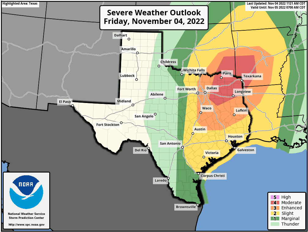
…There will be a threat for severe weather Friday afternoon and Friday evening, mainly for areas along and east of the Interstate 35 corridor and north of Interstate 10. The Austin metro area is included in this threat area. Large hail, damaging winds, and a few isolated tornadoes will all be possible…
The weather is expected to become active across our region Friday afternoon and evening when a trough of low pressure tracks from the southern Rockies to the southern Plains, forcing the dry line and a Pacific cold front to push southeast out of West Texas. In advance of these systems, warm air and considerable moisture has spread inland off the Gulf of Mexico, causing the atmosphere to become unstable. A stable layer of air in the middle atmosphere is forecast to erode around mid-afternoon, and this will allow for the development of isolated to scattered thunderstorms across the eastern Hill Country and much of Central Texas through late afternoon. Any thunderstorm which happens to develop in this area will have the potential to become strong or severe—producing large hail, damaging winds, and large hail.
There will be a better chance for strong to severe thunderstorms late this afternoon and evening when the Pacific cold front pushes east out of the Hill Country. As of noon, the front was situated across West Texas, stretching from Abilene, to San Angelo, to near Sonora. The front is forecast to track east across the Edwards Plateau and Hill Country region this afternoon, reaching the Interstate corridor sometime between 6 and 8 pm. The front is forecast to move across the coastal counties sometime between 10 pm and 1 am.
Friday morning’s high-resolution forecast data calls for scattered thunderstorms to develop along the front around the time the cold front reaches the eastern Hill Country. Some of these storms may quickly become severe. The scattered thunderstorms are predicted to consolidate into a line of thunderstorms by the time the front reaches I-35. The line of storms is then forecast to move southeast, reaching the La Grange/Columbus area around 9-10 pm and the middle Texas coast around 1 am.
Isolated tornadoes, large hail and damaging thunderstorm winds will be possible from the thunderstorms this afternoon and evening. The Storm Prediction Center is now indicating the highest risk for severe storms will be over Northeast Texas, with a somewhat lower threat for severe storms across Central Texas. Nevertheless, across our part of the state, the Storm Prediction Center has placed the eastern Hill Country, all of Central Texas, and the middle Texas coast under a Slight Risk, or a 2 out of 5 risk, for severe thunderstorms through Friday night. It is likely that severe thunderstorm and/or tornado watches could be needed for parts of our area by the late afternoon and evening hours.
The area of rain and storms should exit the Hill Country by early evening, the Austin and Central Texas region by late evening, and the coastal plains region shortly after midnight.
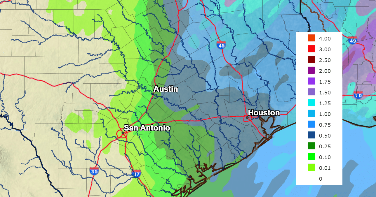
Significant rain is not expected from the storms Friday afternoon and evening. The latest forecasts have trended drier, with 24-hour totals now predicted to be less than a quarter inch across the Hill Country, and between a quarter and a half inch for areas along and east of Interstate 35.
NWS Rainfall Forecast for the Period 7 am Friday through 7 am Saturday:
Mostly sunny and dry weather will be in place this weekend. We’ll see a small cool down Saturday and Saturday night, followed by warmer temperatures Sunday. Highs Saturday are predicted to be in the mid and upper 70s. Lows Sunday morning are forecast to range from the upper 40s west, to the upper 50s near the coast. Highs Sunday are forecast to be in the low 80s.
Friday’s cold front is forecast to return back to the north Sunday night into Monday, allowing considerable moisture to spread north from the Gulf. Forecasts call for a few scattered rain showers and isolated thunderstorms across the region Monday morning and afternoon. Rain amounts should average around a tenth of an inch at most locations. Expect a partly to mostly cloudy sky with a high temperature in the low 80s.
Mostly sunny, dry and warm weather is forecast Tuesday through Thursday. Expect highs in the low 80s and lows in the 60s.
A cold front is predicted to move across our area next Friday. We may see a few showers along the front, but rain amounts are forecast to average less than a quarter inch. Sunny, dry, and cooler weather will follow the cold front next weekend into the following week. Expect highs to fall to the upper 60s, with lows in the upper 40s to low 50s.
Tropical Weather Outlook
The National Hurricane Center is following the progress of Tropical Depression Lisa located over the Bay of Campeche, and two areas of disturbed weather across the western Atlantic.
As of 10 am CDT, the center of Tropical Depression Lisa was located over the Bay of Campeche, about 185 miles west of Ciudad Del Carmen, Mexico. The depression is moving toward the northwest near 7 mph. A gradual turn toward the north at a slower forward speed is expected by Saturday morning. Lisa or its remnants are then forecast to stall and move very little through the remainder of the weekend. Maximum sustained winds are near 35 mph with higher gusts. Slight strengthening is possible today. Lisa is forecast to begin weakening by Saturday morning and will likely become a post-tropical remnant low by Saturday night.
Across the southwestern Atlantic, a large non-tropical low pressure system is expected to develop across the northeastern Caribbean Sea and southwestern Atlantic during the next day or two. The system is initially expected be very broad and disorganized, but it could begin to acquire subtropical or tropical characteristics by the end of the weekend. Environmental conditions could support additional gradual development early next week and a subtropical or tropical depression could form while the disturbance moves generally northwestward or westward over the southwestern Atlantic. NHC forecasters are giving this system a 40 percent chance for tropical development over the next 5 days.
A weak non-tropical area of low pressure located several hundred miles east-southeast of Bermuda is producing an area of showers and thunderstorms, mostly well to the east of its center. Any tropical or subtropical development of this disturbance should be slow to occur during the next day or so while it moves little through today and then turns westward over the weekend. The system is forecast to interact with a larger low pressure area developing to its southwest and will encounter stronger upper level winds on Saturday, so further development is not anticipated beyond that time. NHC forecasters are giving this system just a 10 percent chance for development over the next 5 days.
Time Change Weekend
Daylight Saving Time will come to an end this coming Sunday, November 6th, at 2:00 am. At that time, we will “fall back”, turning our clocks back one hour. Going forward, the evenings will get dark much sooner, but it will get light earlier in the mornings.
Have a good weekend!
Bob
Social Media