Heavy rain spread across the northern portions of Texas Sunday night into Monday morning, producing a very dangerous, life-threatening flash flood event in the Dallas-Fort Worth Metroplex. Much of the Metroplex has seen between 6 and 10 inches of rain. But the heaviest so far have fallen from downtown Dallas, east along I-30, and southeast to Loop 122. Within this area 10 to 15 inches of rain has fallen in just the past 12 hours, leading to widespread flooding!
As of early Monday afternoon, weather radar showed widespread rain continuing across North and Northeast Texas, with this area of precipitation spreading to the east. An area of moderate rain and thunderstorms was beginning to develop across the Hill Country.
The chance for moderate to heavy rain is predicted to increase across the Hill Country and the Interstate 35 corridor regions this afternoon and tonight as slow-moving cold front sinks south out of North Texas. As the cold front advances to the south, it will be encountering an increasingly unstable atmosphere with a very high moisture content. High-resolution forecast solutions call for rain showers and thunderstorms to develop and increase in areal coverage across the northern Hill Country early this afternoon, with the activity spreading southeast across the Hill Country this afternoon, reaching the Austin/Interstate 35 corridor in the late afternoon/early evening. Some of this rain could be locally heavy, with intense rain rates of 2-3 inches per hour. A few of today’s storms may also produce strong wind gusts to around 40 mph.
Forecasts call for the rain to decrease in coverage across the Hill Country late this evening, with the precipitation shifting more toward Central Texas and the coastal plains overnight.
Forecasts call for another round of rain showers and thunderstorms to develop across the Hill Country Tuesday morning, with the activity spreading southeast across the region Tuesday into Tuesday night. Once again, locally heavy rain will be possible.
The National Weather Service has posted a Flash Flood Watch for the eastern Hill Country and the Interstate 35 corridor from 1 pm Monday afternoon, through Tuesday morning. The watch does include the Austin metro area. Extensive street and low-water crossing flooding will be possible. In addition some roads and low-water crossings may become impassable.
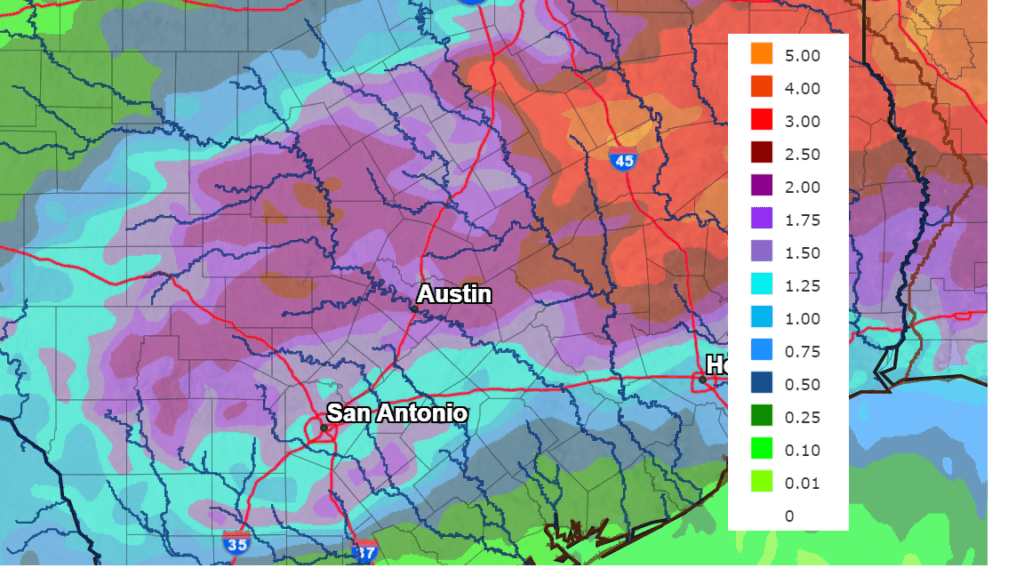
Rain forecasts between Monday and late Tuesday call for widespread totals of 1-3 inches across the Hill Country and the Interstate 35 corridor, with isolated totals to near 5 inches possible. Somewhat lower totals are expected for areas east of Interstate 35 and towards the coast.
NWS Rainfall Forecast for the Period 7 am Monday through 7 am Wednesday:
Wednesday through the upcoming weekend, forecasts call for the unsettled, wet weather pattern to continue as the cold front remains stalled over our region. Additional rounds of rain showers and thunderstorms are forecast, with the highest probability for rain expected to occur Wednesday through Friday. Totals of 1-2 inches are forecast across the Hill Country and Central Texas regions between Wednesday and Sunday. Lower totals can be expected towards the coast.
Temperatures will less hot this week due to the rain and cloud cover. Expect daily high temperatures to generally be in the upper 80s to low 90s.
Bob
Social Media