As of mid-afternoon, weather conditions were cloudy, but quiet across the Hill Country, Central Texas and the Hill Country. Weather radar has been showing some light showers moving over parts of Blanco, Burnet and Hays Counties, but totals have only been a couple hundredths of an inch. Tuesday’s analysis showed a fairly strong stable layer in the middle atmosphere that is limiting the development of showers and thunderstorms at least for now. The focus for storm development late this afternoon and evening is expected to be out west across the Edwards Plateau and Concho Valley region in the vicinity of the West Texas dry line. High-resolution forecasts call for scattered thunderstorms to develop along the dry line late this afternoon and early evening, with the storms slowly spreading east across the Hill Country late this evening and overnight. Some of the storms could make it as far east as the I-35 corridor late tonight and toward daybreak Wednesday before the storms weaken.
Thunderstorms this evening and overnight will have the potential to become strong to severe, with the primary threats being large hail and damaging winds. The Storm Prediction Center has placed much of the Hill Country, generally west of a San Antonio to Goldthwaite line under a Slight Risk for severe thunderstorms overnight. The Austin area and most of Central Texas has been placed under a Marginal Risk for severe storms.
Evening and overnight totals across the Hill Country are forecast to average between 0.5 and 1 inch, with isolated totals to near 2 inches possible.
The next round of showers and thunderstorms is forecast to develop mid to late Wednesday afternoon across the Edwards Plateau and the western Hill Country. These storms will also have the potential to become severe. Severe weather threats will include large hail, damaging winds and isolated tornadoes. The Storm Prediction has placed all of the Hill Country and the area west of Interstate 35 under a Slight Risk (a 2 out of 5 risk) for severe thunderstorms Wednesday and Wednesday night. Much of Central Texas is currently under a Marginal Risk (a 1 out of 5 risk) for severe thunderstorms.
The area of rain and storms is forecast to slowly spread east across the Hill Country late Wednesday afternoon and evening, moving into the Austin/Central Texas region sometime Wednesday evening. The showers and storms are predicted to remain over both areas Wednesday night, with most of the activity exiting to the northeast Thursday morning. Due to the slow movement of the rain and storms and an unusually moist atmosphere, significant totals of rain will be possible—especially across the Hill Country. Occasional light showers and isolated thunderstorms will continue across the area on Thursday, but heavy rain is not expected. All of the rain is forecast to exit the region Friday morning.
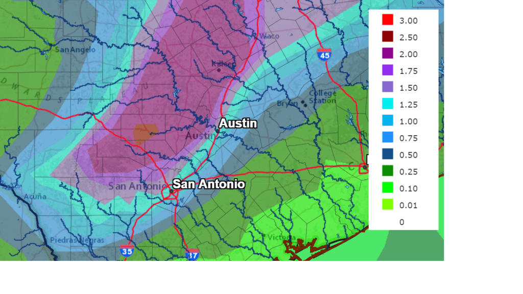
The majority of the rain over the next couple of days is forecast to fall Wednesday afternoon through Thursday morning. The National Weather Service’s rainfall forecast calls for widespread totals of 1-2 inch totals across the Hill Country and Central Texas. Isolated totals of 3-5 inches will be possible across parts of the Hill Country.
NWS Rainfall Forecast for the Period 7 pm Tuesday through 7 pm Friday.
Bob
Social Media