It seems the “Dog Days of Summer” were definitely settling in across our region last week as the center of the high pressure ridge persisted across West and Northwest Texas. But with the center of the ridge moving off to the Tennessee Valley over the weekend, this opened the door for clouds and tropical moisture to spread inland off the Gulf of Mexico. With a weaker ridge in place, temperatures weren’t quite as hot and spotty rain showers developed over much of the area along and to the east of Interstate 35. This moist flow off the Gulf of Mexico is forecast to continue all week and through the upcoming weekend, keeping temperatures below the century mark and bringing at least a slight chance for rain to the entire region.
Forecasters are closely monitoring two tropical waves that are predicted to have some impact on our region’s weather this week.
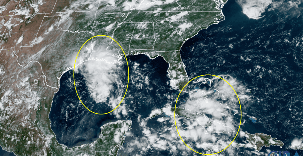
RAMMB-CIRA 07/20/2020 12:30 pm CDT
The first tropical wave was located midday Monday over the northwestern Gulf of Mexico. Surface observations showed a weak area of low pressure had developed to the south of Beaumont. National Hurricane Center forecasters noted the associated shower and thunderstorm activity had become a little better around midday. However, the system is expected to move inland over Texas tonight or Tuesday before significant additional development can occur. The wave and its associated area of low pressure is forecast to track to the west Tuesday into Tuesday night.
Moisture associated with the tropical wave is forecast to spread inland along the middle Texas coast this afternoon and tonight, resulting in the development of a good coverage of rain showers and isolated thunderstorms for locations to the south of Interstate 10. The probability for rain will be 50 percent. Rain amounts through Tuesday morning should average between 0.5 and 1 inch, with isolated totals to near 2 inches possible. There will be a slight increase in tropical moisture across Central Texas and the eastern Hill Country regions this afternoon and evening, resulting in the development of some widely scattered rain showers and thunderstorms. The probability for rain at any given location will only be 20 percent and rain amounts should average less than a quarter inch. Today’s temperature is forecast to generally reach the mid and upper 90s. Lower 90s are expected towards the coast.
A chance for rain showers and isolated thunderstorms is forecast across the entire region Tuesday as the tropical wave and its associated moisture tracks further to the west. The highest probability for rain will be along the middle Texas coast at 50 percent. The probability for rain will be near 30-40 percent across Central Texas and near 20-30 percent across the Hill Country. Rain amounts will generally average between 0.25 and 0.5 inches, with isolated heavier totals. High temperatures Tuesday will be mostly in the mid-90s.
A slight chance for scattered rain showers and thunderstorms is forecast across the entire region Wednesday as an area of tropical moisture lingers across the area. The probability for rain will be near 20 percent and rain amounts should average around a quarter inch. The deepest moisture associated with the tropical wave is expected exit our region and push west towards Mexico. High temperatures Wednesday are predicted to be mostly in the mid-90s.
Thursday’s weather is shaping up to be generally dry and mostly sunny. A few spotty showers will still be possible across the coastal region in a zone of lingering moisture. High temperatures Thursday will generally be in the upper 90s, with mid-90s expected towards the coast.
The outlook for Friday and this weekend will be heavily dependent on the movement and possible development of tropical wave #2. Monday’s analysis showed the tropical wave stretching from the Bahamas to south of Cuba. National Hurricane Center forecasters call for the wave to move west-northwestward through the Straits of Florida today, move over the southeastern Gulf of Mexico Tuesday and the central Gulf of Mexico on Wednesday. The tropical wave is forecast to reach the northwestern Gulf on Thursday. Environmental conditions across the central and western Gulf of Mexico appear generally favorable for slight development of this wave later this week. In fact, some of Monday morning’s guidance suggests an area of low pressure may develop as the wave axis reaches the western Gulf late Thursday. The system is forecast to move inland somewhere along the middle or upper Texas coast on Friday. An Air Force Reserve Hurricane Hunter aircraft is scheduled to investigate the system tomorrow, if necessary. NHC forecaster are currently giving this system a 20 percent chance for tropical development over the next five days.
It’s too early to tell whether an organized tropical depression or tropical storm may develop later this week. Nevertheless, this system is expected to bring an increasing chance for rain showers and thunderstorms to the entire region Friday and Saturday, with lingering rains continuing Sunday. The forecast for rain totals over this period is very uncertain at this point and will depend heavily on whether an organized system develops, or whether the system remains an open wave. As of now, rain amounts of 0.5-1 inch are suggested.
The outlook for next week calls for mostly sunny and hot weather. The center of the high pressure ridge is forecast to remain up to our north, shifting from the middle Mississippi Valley early in the week to the Four Corners region late week. There will be a slight chance for a few rain showers through the first half of the week as tropical moisture lingers over the area. High temperatures will generally be in the mid and upper 90s. Some triple digit temperatures could return by the start of August.
Tropical Weather Outlook
In addition to the two tropical waves over the Gulf of Mexico, National Hurricane Center forecasters are also monitoring a tropical wave in the eastern tropical Atlantic, roughly about 1000 miles west-southwest of the Cabo Verde Islands. Shower and thunderstorm activity has become a little better organized this morning and environmental conditions are expected to be marginally conducive for development of this system during the next few days while it moves westward at 10 to 15 mph over the tropical Atlantic. By Friday and over the weekend, conditions are forecast to become less favorable for tropical cyclone formation.
NHC forecasters are giving this system a 20 percent chance for tropical development over the next 5 days.
Comet NEOWISE Update
Many people were able to see comet NEOWISE over the weekend, but for many (including myself), weather and sky conditions just didn’t cooperate. But don’t give up, the comet will still be visible in the evening sky all of this week. Comet NEOWISE will be closest to Earth Wednesday and Thursday nights, offering up more good views. Binoculars are pretty much now required to see our celestial visitor as it has dimmed a bit. Otherwise, it will appear as a weak smudge of light to the unaided eye.
Check out a great NEOWISE update from Earthsky.org https://earthsky.org/space/how-to-see-comet-c2020-f3-neowise
Bob
Social Media