It certainly felt like fall Thursday morning! The combination of a Canadian air mass, a clear sky and light winds allowed temperatures to cool into the 40s and 50s—the coolest temperatures observed since May. According to LCRA’s Hydromet, minimum temperatures were a mixture of 40s and 50s across the Hill Country and Central Texas, and in the mid to upper 50s across the coastal plains. The lowest temperature observed was a crisp 39 degrees at spots in northwestern Kimble and northeastern Edwards Counties. In Austin, the low temperature at Austin-Camp Mabry was 58 degrees, while Austin-Bergstrom saw a low temperature of 48 degrees. Low temperatures Friday morning will again be in 50s across the region.
In the tropical Atlantic, the strong tropical wave over the eastern tropical Atlantic strengthened earlier today to become Tropical Storm Sam—the 18th named storm of the 2021 Atlantic Hurricane Season. It is interesting to note this is the 2nd earliest formation of the 18th named storm in the Atlantic basin, moving ahead of the 2005 hurricane season, and trailing 2020.
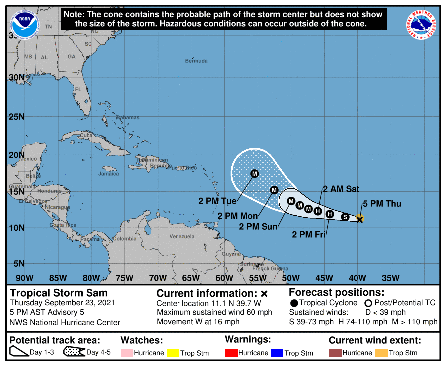
As of 4 pm CDT Thursday, the center of Tropical Storm Sam was located just over 1600 miles east of the northernmost Leeward Islands. Sam was moving toward the west near 16 mph, and a general west to west-northwest motion is expected to continue over the next several days, with a gradual slowdown in forward motion. Sam is located in an environment that is quite favorable for strengthening. Maximum sustained winds have already increased to near 60 mph with higher gusts. Rapid intensification is forecast during the next several days. Sam is forecast to become a hurricane Friday morning and could become a major hurricane by Saturday.

NOAA/Colorado State University/RAMMB 09/23/21 12:10 pm CDT
Sam is moving to the west-northwest around a large and anomalously strong mid-level ridge of high pressure located to the north of the storm. Sam is forecast to move unusually slow for a tropical cyclone in the deep tropics this weekend when it moves east of the Lesser Antilles. Afterwards, a weakness in the ridge to the northwest is forecast to gradually develop as a broad deep-layer trough parks itself just offshore of the eastern United States by early next week. This could potentially allow Sam to gain a bit more latitude at a somewhat faster forward motion as the ridge axis shifts back to the east. With this more northward motion, the threat for Sam to move west into the Gulf of Mexico has decreased significantly. Long-range computer-forecast solutions generally agree Sam will turn north-northwest and take a path well east of the U.S. East Coast. However, it’s early and everyone should still keep an eye on the progress of Sam.
The outlook for rain continues to increase next week. Thursday’s data now calls a 50 percent chance for rain Tuesday through Thursday, with cumulative totals of 1-2 inches for locations east of Interstate 35 and totals of 0.5 to 1 inch across the Hill Country.
I have more details on next week’s wet pattern in Friday’s report.
Bob
Social Media