Welcome to the month of August! August 1st is the traditional mid-point of astronomical summer, so one would think the worst of summer is now behind us. Unfortunately, it doesn’t generally work that way in Texas weather. From a climate perspective, the first half of August is typically the hottest point of summer, with temperatures trending down after that. This year isn’t fitting this profile very well as our region has been experiencing August-like temperatures since early June. Can true August weather get any worse?
The hot and dry pattern continues as we kick off the new month. The culprit for the this pattern, a broad ridge of high pressure, or heat dome, is currently centered over northern New Mexico. This feature is keeping temperatures quite hot while at the same time repelling potential storm systems and cold fronts. Monday’s forecast solutions call for the center of the ridge to slide east to the southern Plains states mid-week, then shift northeast to middle Mississippi Valley region Friday and through the upcoming weekend. In addition to the stout ridge of high pressure, two separate tropical waves of low pressure from the Gulf of Mexico are expected to have some influence on our region’s weather this afternoon, and also late week and into the weekend.
For this afternoon and Tuesday, a weak tropical wave or trough of low pressure over the western Gulf of Mexico, will be moving inland along the Texas and Mexican coasts. An enhanced area of tropical moisture associated with the wave is forecast to spread about 75 miles inland and is expected to cause the development of a few isolated rain showers and thunderstorms across the coastal plains region. The probability for rain will only be 20 percent and totals should stay well below a quarter inch. For the rest of the region, expect more mostly sunny, dry and hot weather.
- High temperatures Monday and Tuesday are predicted to be near 98-103 degrees across the Hill Country and Central Texas regions, and in mid-90s across the coastal plains.
Wednesday and Thursday are shaping up to be the hottest days of the week as the center of the heat ridge draws closer to our region. Dry conditions are forecast both days.
- High temperatures Wednesday and Thursday are predicted to be around 101-105 degrees across the Hill Country and Central Texas regions, and near 98-100 degrees across the coastal plains.
A slight chance for showers and isolated thunderstorms will enter the forecast for areas along and east of Interstate 35 Friday, and for the entire region over the weekend when tropical wave #2 begins to spread inland along the Texas coast. This particular wave is forecast to have more moisture with it. And with the ridge of high pressure weakening a bit late week and through the weekend, conditions are looking favorable for at least a slight chance for a few scattered rain showers and thunderstorms. This will just be a slight chance for rain, as most locations will likely remain dry.
For Friday, the probability for rain will be 30 percent for areas located to the east of Interstate 35. For Saturday and Sunday, the probability for rain will be 20 percent across the Hill Country and the Interstate 35 corridor, and near 30-40 percent for area east of Interstate 35. Rain amounts Friday through Sunday are not forecast to be very much; averaging around a tenth of an inch or less across the Hill Country and Central Texas regions, and around a half to three-quarters of an inch across the coastal plains region.
- High temperatures Friday through Sunday are forecast to be around 98-101 degrees across the Hill Country and Central Texas regions, and in the mid-90s across the coastal plains.
The outlook for next week calls for few changes in the pattern. The center of the high pressure ridge is predicted to remain over the southern Plains and the middle Mississippi Valley region throughout the week. A moderate flow off the Gulf will cause a very slight chance for rain for the coastal region, while most other locations look to stay dry. High temperatures are forecast to be around 100-103 degrees across the Hill Country and Central Texas regions, and in the upper 90s across the coastal plains.
Tropical Weather Outlook
Weather conditions continue quiet across the tropical Atlantic. There are no systems in place which pose a threat for tropical development over the next 5 days.
A Record Hot or Near-Record Hot July Across the Texas
July temperatures generally averaged between 4 and 6 degrees above normal across the Hill Country and Central Texas, and between 2 and 4 degrees above normal across the coastal plains. July 2022 rivals some of the hottest Augusts on record.
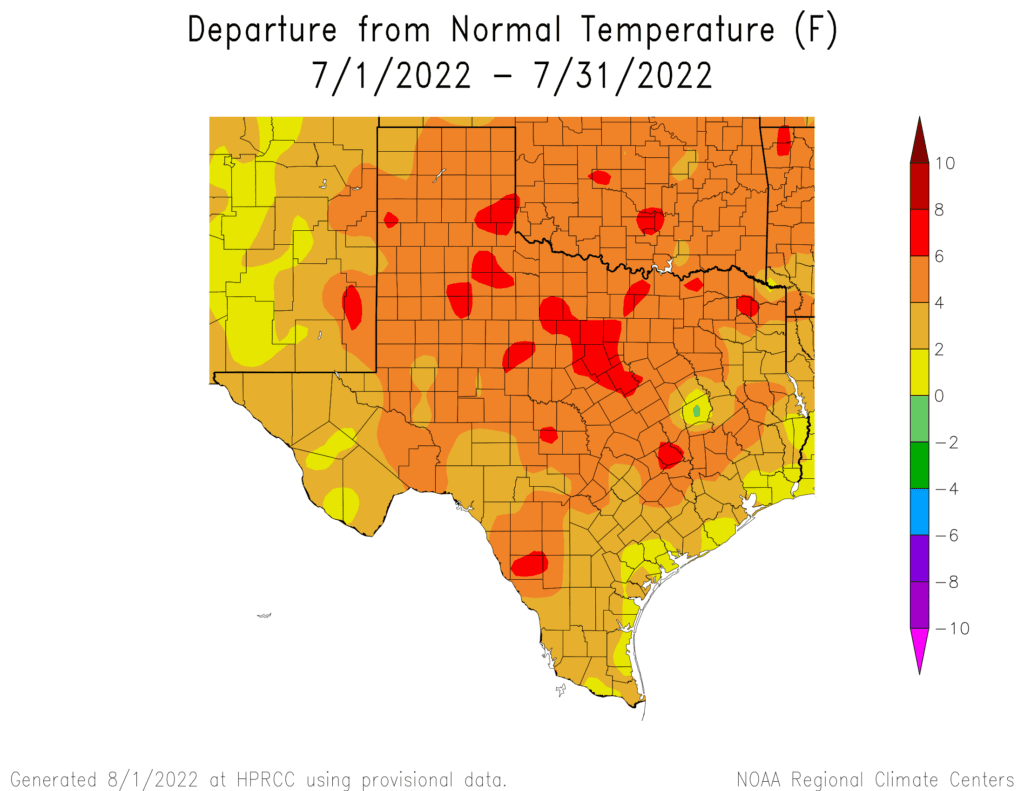
According to preliminary data provided by John Nielsen-Gammon, the Texas State Climatologist, it looks like July 2022 is in a virtual tie with 2011 for the hottest July on record for Texas. Adding in June, this would make this the second hottest June-July, and the hottest May-July, and April-July on record for Texas.
The rainfall data is somewhat less certain at this time, but it appears that this will not be a top-ten dry July for Texas. But combined June-July will probably come out fifth or sixth driest on record, and year-to-date will be somewhere around the 2nd to 4th driest on record, behind 2011 and possibly 1917 and 1956.
Individual cities including Austin, San Antonio, Houston, College Station, and Galveston all recorded their hottest July on record.
Stay tuned for amazing July climate statistics over the next few days.
Bob
Social Media