Welcome to the month of July! This month is typically the second hottest month of the year behind August.
Forecasters continue to monitor the progress a disorganized area of low pressure that persisted across the western Gulf for the past couple of day. The low pushed inland along the middle Texas coast early this morning and as of midday, it was centered along the upper Texas coast between Bay City and Angleton. So far, the heaviest rains associated with the low have been over the Gulf waters and the upper Texas coast, to the south of Houston. Totals inland have been low. According to LCRA’s Hydromet, totals over the past 48 hours have generally averaged less than a quarter inch across Wharton and Matagorda Counties. The highest gauged total so far has been near Sargent, in southeastern Matagorda County, where 1.79 inches has been recorded.
High-resolution forecasts call for the weak low pressure system to move slowly northeast Friday afternoon and Friday night, with the heaviest rains staying on the eastern side of the low. Based on this, the threat for heavy rain along the middle Texas coast has decreased. The Flash Flood Watch issued previously for Wharton and inland Matagorda counties has been canceled. For these two counties, there will be a 50 percent chance for scattered rain showers and thunderstorms this afternoon as tropical moisture wraps around the low center. However, additional rain amounts are forecast to only average around a quarter inch.
A few isolated rain showers and thunderstorms will be possible across the Hill Country region this afternoon and early evening due to the circulation around a weak area of low pressure located over northeastern Mexico. The probability for rain will only be 20 percent, with rain amounts averaging well below a quarter inch. Between the low near the coast and the upper low over Mexico, the Central Texas region is forecast to remain mostly sunny and dry this afternoon and evening.
- High temperatures Friday afternoon are forecast to be in the mid and upper 90s across the Hill Country and Central Texas regions. Towards the coast, high temperatures are predicted to be in the upper 80s to low 90s.
For Saturday, there will be a slight chance for rain showers and isolated thunderstorms across the entire region due to persistent low pressure area over northeastern Mexico and lingering tropical moisture over the eastern half of the area. The probability for rain will only be 20 percent, with rain amounts averaging less than a tenth of an inch. Otherwise, expect a mostly sunny sky with high temperatures in the mid and upper 90s. There will be a southerly breeze in the range of 10-15 mph.
A sunny, dry, and hot weather pattern will begin to take hold Sunday as both low pressure systems exit the region and a large ridge of high pressure, or heat dome, begins to expand across the south central and southeastern U.S. Forecasts call for the ridge to remain in place all of next week, while the center of the ridge shifts from lower Mississippi Valley on Monday, to the southern Rockies late week. The strengthening ridge is expected to bring the return of triple-digit temperatures to much of the region beginning Monday and persisting throughout the week.
- High temperatures next week are forecast to be near 101-104 degrees across the Hill Country, be around 100-102 degrees across Central Texas, and in the upper 90s across the coastal plains.
Longer-range forecasts looking out into the week of July 11th call for few, if any changes through the first half of the week. We may see more of a Gulf influence the second half of the week as the ridge is predicted to shift to the southeastern U.S. Little change in the temperature is forecast.
Tropical Weather Outlook
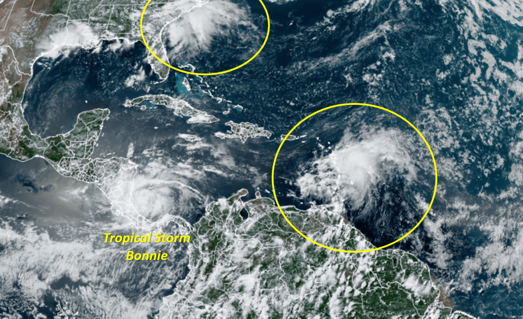
Tropical Storm Bonnie was declared Friday morning for the system over the western Caribbean Sea. Well-organized deep convection persisted into the morning, and an Air Force Reserve Hurricane Hunter mission found a well-defined circulation center located about 100 nautical miles east of the Nicaragua coast.
As of 1 CDT, the center of Tropical Storm Bonnie was located about 150 miles east-southeast of Bluefields, Nicaragua. Bonnie was moving toward the west near 20 mph and a continued westward motion, with a gradual decrease in forward speed is expected through Saturday night. A west-northwestward motion is expected to begin on Sunday and continue into Monday. On the forecast track, the system will move across the southwestern Caribbean Sea today, cross southern Nicaragua or northern Costa Rica tonight, and emerge over the eastern Pacific Ocean on Saturday. The system will then move offshore of but parallel to the coasts of El Salvador, Guatemala, and southern Mexico Saturday through Monday.
Maximum sustained winds were near 40 mph with higher gusts. Bonnie is expected to strengthen before it makes landfall Friday night. After landfall, short term weakening is forecast on Saturday, but Bonnie is expected to re-strengthen later this weekend and early next week over the eastern Pacific.
National Hurricane Center forecasters continue to monitor a strong tropical wave located about 100 miles east of the Windward Islands. This system is producing an area of disorganized showers and thunderstorms. The associated shower activity and gusty winds are expected to spread across the Windward Islands later today. Significant development of this system is not expected to occur while it moves westward into unfavorable conditions over the eastern Caribbean Sea. NHC forecasters are giving this system a low probability, or 10 percent chance, for tropical development over the next 5 days.
Satellite and radar images along with surface observations indicate that a low pressure system has formed just off the coast of Savannah, Georgia. Surface pressures are high in this region, and development, if any, of this system should be slow to occur while it drifts northeastward along the southeast U.S. coastline during the next day or so. Regardless of development, this system is expected to produce heavy rains, which could cause flash flooding across portions of southeastern Georgia and the Carolinas through Friday night and into Saturday.
Elsewhere, weather conditions are quiet and tropical cyclone development is not expected over the next 5 days.
A Record Hot Month of June
The numbers are in and June 2022 was the hottest June on record for Austin-Camp Mabry, San Antonio, Houston and Del Rio.
In Austin, the average temperature for the month was 87.7 degrees, which was 4.7 degrees above normal, and 0.6 degrees ahead of June 2011. To put into perspective just how record hot this is, the average Austin temperature for July is 85.8 degrees and the average Austin temperature for August is 86.5 degrees. The hottest June follows a record hottest May and the 6th hottest April on record.
- The average maximum temperature for the month was 100.4 degrees—the highest average maximum June temperature ever observed.
- Austin recorded 21 triple-digit temperatures—the most ever for the month of June.
- Austin recorded 12 consecutive triple-digit temperatures—the longest streak ever recorded in the month of June.
All of this and it’s just early July…
I hope everyone has a safe and happy Fourth of July weekend! Remember to stay cool and hydrated.
Bob
Social Media