A fairly quiet weather pattern is in place across Central and South Texas, thanks to a stable ridge of high pressure centered over northern Mexico. This quiet weather pattern is forecast to persist through Monday, with generally dry and warm weather expected across the Hill Country and Central Texas regions. Spotty rain showers and isolated thunderstorms are expected to continue across the coastal plains region as the Sea Breeze front pushes inland each morning. A change in the weather pattern is predicted to take place beginning Monday night as a large trough of low pressure drops south into Texas out of the Mississippi Valley. The trough is forecast to cause the development of widespread rain showers and thunderstorms Tuesday and Wednesday, followed by scattered showers and thunderstorms Thursday and Friday. Rain forecasts for the next seven days calls for widespread totals of 1-2 inches, with isolated higher totals.
This afternoon through Sunday, expect a mostly sunny sky and dry weather across the Hill Country and the Interstate 35 corridor, including Austin. High temperatures each day are forecast to be in the low and middle 90s. For areas east of Interstate 35 and the coastal plains, expect a 20-30 percent chance for scattered mainly afternoon showers and thunderstorms. Spotty totals to around a quarter inch are forecast each day along with high temperatures in the low 90s. There will be a nice southerly breeze at 10-15 mph this afternoon and Saturday, but wind speeds are forecast to decrease to around 5-10 mph on Sunday.
For Monday, mostly sunny and warm weather will continue. However, there will be a slight chance (20 percent chance) for scattered afternoon showers and thunderstorms across the Hill Country and the Interstate 35 corridor. There will be a 30-40 percent chance more scattered showers and thunderstorms across the coastal plains region. Totals should average around a quarter inch or less. Monday is shaping up to be a warm day, with high temperatures generally around 95-96 degrees.
The chance for rain and thunderstorms is predicted to increase to near 50 percent across the region Monday night when a large trough of low pressure begins to sink southwest into the state.
Periods of rain showers and thunderstorms will follow Tuesday and Wednesday when a weak cold front settles south into the area. The combination of abundant tropical moisture and good atmospheric lift is expected to cause a pattern favorable for the development of widespread rain showers and thunderstorms. Rainfall forecasts call for 2-day totals to average between 1 and 2 inches, with isolated totals of 3-4 inches possible. The threat for severe storms during this period will be low. Widespread clouds and rain Tuesday and Wednesday are expected to hold high temperatures to the upper 80s.
The outlook for next Thursday and Friday calls for 30-40 percent chance for scattered, mainly afternoon and evening showers and thunderstorms as the trough weakens and shifts off to the west. Daily rain amounts are predicted to average around a quarter inch. High temperatures both days are forecast to be in the low 90s.
Looking ahead to next weekend, there will be just a slight chance for showers as tropical moisture lingers over the area. Otherwise, expect a mostly sunny sky with high temperatures in the low to mid-90s.
The outlook for the week of July 26th calls for mostly sunny and hot weather throughout the week, with just a slight chance for a few isolated showers. High temperatures look to generally be in the mid-90s, although a few spots could reach the upper 90s.
Tropical Weather Outlook
Weather conditions are currently quite across the tropical Atlantic, with considerable Saharan dust noted between the Lesser Antilles and the coast of Africa. There are no systems in place which pose a threat for tropical development over the next 5 days.
In the eastern tropical Pacific, Category 3 Hurricane Felicia was located more than 900 miles southwest of the southern tip of the Baja California peninsula. Top winds are near 125 mph. Felicia is a strong category 3 hurricane on the Saffir-Simpson Hurricane Wind Scale. Some additional strengthening is possible today, and Felicia could become a category 4 hurricane later this morning. Slow weakening is expected to begin by tonight, and continue through the weekend and into early next week. Felicia is moving to the west-southwest at 8 mph over the open Pacific, posing no threat to any land area.
To the east of Felecia, forecasters are monitoring a broad area of low pressure located several hundred miles south of the coast of southern Mexico. Environmental conditions are expected to be conducive for gradual development during the next several days, and a tropical depression is likely to form over the weekend and move westward or west-northwestward at around 15 mph,
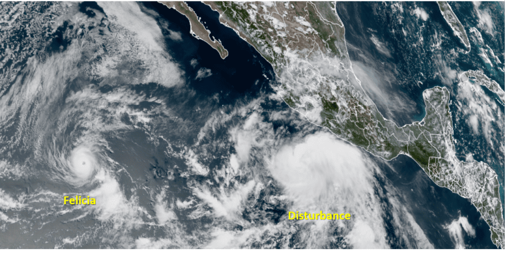
NOAA/Colorado State University/RAMMB 07/16/21 2:20 pm CDT
Jupiter and Saturn Have Returned to the Evening Sky
Saturn (magnitude +0.2, in Capricornus) and brighter Jupiter (magnitude –2.8, in Aquarius) both rise in the east-southeast in twilight, Jupiter an hour after Saturn. By late evening they make an impressive duo in the southeastern sky. Jupiter will grab your eye first. Find Saturn 20° to its upper right.
They’re highest in the south, at their telescopic best, around 2 a.m. DST. Both planets will reach opposition next month, so they’re already about as close and big as they’ll get in our sky.
Have a good weekend.
Bob
Social Media