Wednesday morning, National Oceanic and Atmospheric Administration (NOAA) forecasters released their latest hurricane outlook, calling for even greater odds there will be an above-normal number of tropical storms and hurricanes this year. That would make 2021 the sixth consecutive year to feature above-average tropical storm activity.
Matthew Rosencrans, a meteorologist at NOAA’s Climate Prediction Center, stated in a news conference Wednesday NOAA’s outlook indicates an above average season appears likely. “The number of named storms is likely to be 15 to 21, which includes 7-10 hurricanes and 3-5 major hurricanes.” That’s an increase from its May prediction for 13 to 20 named storms and 6 to 10 hurricanes. The forecast for the number of major hurricanes was unchanged.
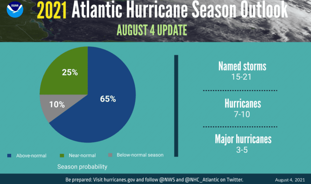
“Given an increase in the predicted number of named storms and hurricanes, there is now a 65 percent chance of an above-average season, and only a 10 percent chance for a below-average season,” said Rosencrans.
The predictions are based on a number of factors that take into consideration large-scale features of both the atmosphere and ocean.
In recent weeks, the Atlantic has been very quiet, without any storms anywhere in the basin since the dissipation of Elsa on July 9. Elsa brought heavy rain and tornadoes to parts of the East Coast. This quiet period has been the result of widespread sinking air over the Atlantic that suppressed upward motion and updrafts, limiting the type of thunderstorm activity that occasionally organizes into a storm. In addition, there have been several bursts of Saharan dust, which also limited the development of thunderstorms across the Atlantic.
This all looks to change in the coming weeks when the combined effects of several large-scale circulations bring atmospheric lift to much of the Atlantic. It appears around Aug. 10-14, the Atlantic will begin to wake up. Later in the month, the tropics could become quite busy as rising air across the Atlantic increases further. Historically, this is the point of summer when hurricane activity generally ramps up, so there’s every reason to believe that the latter two weeks of August and early September will be busy.
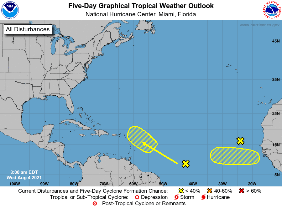
In the near term, National Hurricane Center forecasters are monitoring three disturbances that all have low chances for tropical development. One tropical wave is located just off the west coast of Africa near the Cabo Verde Islands. This system is predicted to track north-northwestward and dissipate over the next couple of days. A second tropical wave is forecast to push off the west coast of Africa by late Thursday. Environment conditions appear favorable for this system to show some slow tropical development over the next few days as it moves to the west over the eastern Atlantic. A third tropical wave is located over the central tropical Atlantic. Environmental conditions around this system are expected to be marginally conducive for some slow development east of the Lesser Antilles by Sunday and early next week.
Bob
Social Media